Dry Fork Mine
The Dry Fork mine is a coal mine located 8 miles north of Gillette, Wyoming in the United States in the coal-rich Powder River Basin. The mine is an open pit mine that utilizes truck and shovel mining method to mine a low-sulfur, sub-bituminous coal that is used for domestic energy generation and shipped to customers via railroad. In 2011, the mine is expected to begin supplying coal to the newly constructed Dry Fork power station that has been constructed adjacent to the mine. The mine is currently owned and operated by Western Fuels Association.[1]
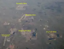 Coal mines north and east of Gillette–Campbell County Airport, including the Dry Fork Mine | |
| Location | |
|---|---|
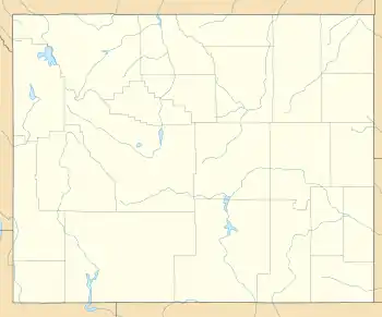 Dry Fork Location in Wyoming | |
| State | Wyoming |
| Country | USA |
| Coordinates | 44°22′59″N 105°27′19″W |
| Production | |
| Products | Coal |
| History | |
| Opened | 1990 |
| Owner | |
| Company | Western Fuels Association |
| Website | www |
| Year of acquisition | 1990 |
As of 2009, Dry Fork had reserves of 330 mm tons of sub-bituminous coal and a maximum permitted production capacity of 15mm tons per year. Typical annual production has been in 5.2mm ton range for the last several years though. In 2008, the mine produced just over 5.2 million short tons of coal, making it the 37th-largest producer of coal in the United States.[2]
The average quality of the coal shipped from Dry Fork is 8,050-8,200 BTU/lb, 0.20-0.42% Sulfur, 3.8-5.1% Ash, and 1.50% Sodium (of the ash). Train loading operations at the mine are done with a batch weigh bin system that is coupled to a "weigh-in-motion" track scale system. Silo capacity at the mine's rail loop, which can accommodate a single unit train, is 10,800 tons.[3][4]
History
The Dry Fork mine shipped its first coal to members of the Western Fuels Association in 1990 and is run by Western Fuels-Wyoming an associate of Western Fuels. Since opening, Dry Fork has shipped 69.5mm tons of coal.
Production
| Year | Coal production | Employees |
|---|---|---|
| 2018 | 6,304,022 | 83 |
| 2017 | 6,045,618 | 82 |
| 2016 | 6,141,433 | 82 |
| 2015 | 6,369,206 | 79 |
| 2014 | 5,373,973 | 79 |
| 2013 | 5,433,936 | 78 |
| 2012 | 6,006,787 | 77 |
| 2011 | 5,776,092 | 79 |
| 2010 | 5,448,073 | 71 |
| 2009 | 5,232,451 | 67 |
| 2008 | 5,261,242 | 71 |
| 2007 | 5,310,716 | 70 |
| 2006 | 5,860,998 | 69 |
| 2005 | 4,093,611 | 61 |
| 2004 | 4,533,621 | 61 |
| 2003 | 4,363,683 | 61 |
| 2002 | 4,891,403 | 65 |
| 2001 | 4,029,100 | 68 |
| 2000 | 2,268,720 | 34 |
| 1999 | 1,219,590 | 9 |
| 1998 | 1,030,718 | 9 |
| 1997 | 918,224 | 8 |
| 1996 | 2,945,662 | 39 |
| 1995 | 3,606,453 | 47 |
| 1994 | 3,836,228 | 51 |
| 1993 | 3,279,801 | 49 |
| 1992 | 3,453,340 | 49 |
| 1991 | 2,786,946 | 43 |
| 1990 | 736,641 | 32 |
| 1989 | 0 | 3 |
References
- "Our Operations". Western Fuels website. Western Fuels. Archived from the original on 2009-09-01. Retrieved 2010-07-03.
- "Major U.S. Coal Mines, 2008". Energy Information Administration of the Department of Energy. September 2009. Retrieved 2010-07-03.
- "Mine Guide" (PDF). BNSF website. BNSF. Archived from the original (PDF) on 2010-11-21. Retrieved 2010-07-03.
- "Basin Electric - Dry Fork Station". ENI website. Archived from the original on 2009-08-01. Retrieved 2010-07-03.
- "Dry Fork Data". Wyoming Mining Association. May 4, 2010. Archived from the original on July 18, 2011. Retrieved 2010-07-03.
- "MSHA Mine ID 4801429". Retrieved 2019-03-27.