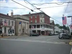
Duncannon, Pennsylvania
Duncannon is a borough in Perry County, Pennsylvania, United States. The population was 1,522 at the 2010 census.[4] It is part of the Harrisburg–Carlisle Metropolitan Statistical Area. The center of population of Pennsylvania is located in Duncannon.[5] Lightning Guider sleds were manufactured in Duncannon from 1904 until 1988.[6] The Appalachian Trail makes its way through the town, going on various streets, and runs mainly along North High Street.[7] It comes off the mountain at 40.3813, -77.0292 lat/long, onto Inn Road.
Duncannon, Pennsylvania | |
|---|---|
 Duncannon | |
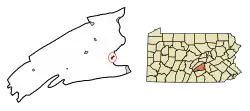 Location of Duncannon in Perry County, Pennsylvania. | |
 Duncannon Location of Duncannon in Perry County, Pennsylvania.  Duncannon Duncannon (the United States) | |
| Coordinates: 40°23′38″N 77°01′14″W | |
| Country | United States |
| State | Pennsylvania |
| County | Perry |
| Settled | 1792 |
| Incorporated | 1844 |
| Area | |
| • Total | 0.41 sq mi (1.05 km2) |
| • Land | 0.41 sq mi (1.05 km2) |
| • Water | 0.00 sq mi (0.00 km2) |
| Elevation [2] (center of borough) | 370 ft (110 m) |
| Highest elevation [2] (western edge of borough) | 506 ft (154 m) |
| Lowest elevation [2] (Susquehanna River) | 340 ft (100 m) |
| Population (2010) | |
| • Total | 1,522 |
| • Estimate (2019)[3] | 1,489 |
| • Density | 3,658.48/sq mi (1,412.18/km2) |
| Time zone | UTC-5 (Eastern (EST)) |
| • Summer (DST) | UTC-4 (EDT) |
| Zip code | 17020 |
| Area code(s) | 717 |
| FIPS code | 42-20240 |
| Website | Borough's website |
History
Duncannon was originally called Petersburg,[8] and under the latter name was laid out in 1792.[9] The present name is derived from Duncan's Island in the Susquehanna River.[10]
The Puritan missionary David Brainerd visited the area in the 1740s. In his journal he describes his trip on the Susquehanna and his brief stay with an Indian tribe on Duncan's Island, across the river from present-day Duncannon.
The Mutzabaugh family has close connection to the town, as their market (now grocery store) named after the family has been a presence in the town since 1920, opening originally along the old railroad crossing between Market Square and High Street.[11]
Geography
Duncannon is located at 40°23′38″N 77°1′44″W (40.393986, -77.028891).[12]
According to the United States Census Bureau, the borough has a total area of 0.4 square miles (1.0 km2), all of it land.
Demographics
| Historical population | |||
|---|---|---|---|
| Census | Pop. | %± | |
| 1870 | 960 | — | |
| 1880 | 1,027 | 7.0% | |
| 1890 | 1,074 | 4.6% | |
| 1900 | 1,661 | 54.7% | |
| 1910 | 1,474 | −11.3% | |
| 1920 | 1,679 | 13.9% | |
| 1930 | 1,732 | 3.2% | |
| 1940 | 1,707 | −1.4% | |
| 1950 | 1,852 | 8.5% | |
| 1960 | 1,800 | −2.8% | |
| 1970 | 1,739 | −3.4% | |
| 1980 | 1,645 | −5.4% | |
| 1990 | 1,450 | −11.9% | |
| 2000 | 1,508 | 4.0% | |
| 2010 | 1,522 | 0.9% | |
| 2019 (est.) | 1,489 | [3] | −2.2% |
| Sources:[13][14][15] | |||
As of the census[14] of 2000, there were 1,508 people, 667 households, and 386 families residing in the borough. The population density was 3,566.5 people per square mile (1,386.3/km2). There were 714 housing units at an average density of 1,688.7 per square mile (656.4/km2). The racial makeup of the borough was 98.28% White, 0.53% African American, 0.07% Asian, 0.73% from other races, and 0.40% from two or more races. Hispanic or Latino of any race were 1.59% of the population.
There were 667 households, out of which 25.8% had children under the age of 18 living with them, 41.8% were married couples living together, 12.3% had a female householder with no husband present, and 42.1% were non-families. 36.1% of all households were made up of individuals, and 16.8% had someone living alone who was 65 years of age or older. The average household size was 2.26 and the average family size was 2.94.
In the borough the population was spread out, with 23.1% under the age of 18, 9.6% from 18 to 24, 28.7% from 25 to 44, 20.3% from 45 to 64, and 18.3% who were 65 years of age or older. The median age was 38 years. For every 100 females, there were 91.1 males. For every 100 females age 18 and over, there were 85.3 males.
The median income for a household in the borough was $33,000, and the median income for a family was $38,750. Males had a median income of $31,643 versus $21,477 for females. The per capita income for the borough was $15,883. About 6.2% of families and 8.5% of the population were below the poverty line, including 8.0% of those under age 18 and 8.2% of those age 65 or over.
Culture
On S. Market Street, there is a mural with various artistic depictions of life and scenery in Duncannon, the entire area that is Perry County, Pennsylvania as a whole, and even of the entire United States.
A high percentage of the population is Christian, and many churches are in Duncannon, including a Lutheran,[16] UCOC, Assembly of God, Presbyterian, Catholic, and Church of God. Many other churches, including multiple Methodist churches, are a few miles away.
Notable people
- William J. Kirkpatrick, musician, composer of Christian hymns
- Marie Doro, silent screen actress
Gallery
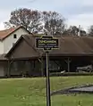
.jpg.webp) Former Duncannon train depot
Former Duncannon train depot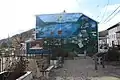
.jpg.webp)
.jpg.webp)
References
- "2019 U.S. Gazetteer Files". United States Census Bureau. Retrieved July 28, 2020.
- "Duncannon Topo Map, Perry County PA (Duncannon Area)". TopoZone. Locality, LLC. Retrieved 26 November 2019.
- "Population and Housing Unit Estimates". United States Census Bureau. May 24, 2020. Retrieved May 27, 2020.
- "Duncannon, PA population". population.us. Retrieved 2017-12-27.
- . 12 December 2001 https://web.archive.org/web/20011212170351/http://www.census.gov/geo/www/cenpop/statecenters.txt. Archived from the original on 12 December 2001. Missing or empty
|title=(help) - by the Duncan family. Old Sled Works History Accessed April 25, 2010.
- "TNM Download". viewer.nationalmap.gov. Retrieved 2017-12-27.
- SusquehannaMan (2017-12-27), Duncannon sign with historic name "Petersburg", retrieved 2017-12-27
- Jordan, John Woolf (1913). A History of the Juniata Valley and Its People. Lewis Historical Publishing Company. p. 223.
- "Historic Liverpool, Pennsylvania History". www.liverpool.pa.net.
- "Mutzabaugh's Market – Duncannon's Grocery Store". www.mutzabaughsmarket.com. Retrieved 2017-12-21.
- "US Gazetteer files: 2010, 2000, and 1990". United States Census Bureau. 2011-02-12. Retrieved 2011-04-23.
- "Census of Population and Housing". U.S. Census Bureau. Retrieved 11 December 2013.
- "U.S. Census website". United States Census Bureau. Retrieved 2008-01-31.
- "Incorporated Places and Minor Civil Divisions Datasets: Subcounty Resident Population Estimates: April 1, 2010 to July 1, 2012". Population Estimates. U.S. Census Bureau. Archived from the original on 17 June 2013. Retrieved 11 December 2013.
- "Christ Lutheran Church". Christ Lutheran Church. Retrieved 2017-12-27.
External links
![]() Media related to Duncannon, Pennsylvania at Wikimedia Commons
Media related to Duncannon, Pennsylvania at Wikimedia Commons
Municipalities and communities of Perry County, Pennsylvania, United States | ||
|---|---|---|
| Boroughs | 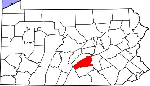 | |
| Townships | ||
| Unincorporated communities | ||
| ||
| Authority control |
|---|