Dzhankoi Raion
Dzhankoi Raion (Ukrainian: Джанкойський район, Russian: Джанкойский район, Crimean Tatar: Canköy rayonı) is one of the 25 regions of Crimea, currently subject to a territorial dispute between the Russian Federation and Ukraine. Population: 68,429 (2014 Census).[1]
Dzhankoi District
Canköy rayonı | |
|---|---|
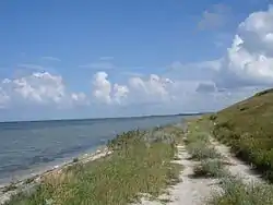 Kalinovsky Nature Park, Dzhankoi District | |
 Flag  Seal | |
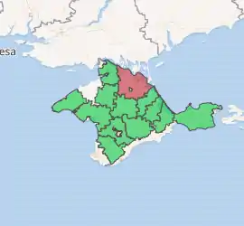
Dzhankoi Raion location within Crimea | |
| Country | Disputed: |
| Republic | Crimea |
| Capital | Dzhankoi |
| Subdivisions | List
|
| Area | |
| • Total | 2,667 km2 (1,030 sq mi) |
| Population (2014) | |
| • Total | 68,429 |
| • Density | 26/km2 (66/sq mi) |
| Time zone | UTC+3 (MSK) |
| Dialing code | +380-6564 |
| Website | dzhankoy-rayon |
It is located in the northern part of the Crimean steppe near the Syvash Bay. The city of Dzhankoi is the raion's administrative centre, but it is excluded from the region and forms a separate municipality. The North-Crimean canal (the main waterway of northern Crimea supplying the republic with water from the Dnieper river) runs through the district.
References
- Russian Federal State Statistics Service (2014). "Таблица 1.3. Численность населения Крымского федерального округа, городских округов, муниципальных районов, городских и сельских поселений" [Table 1.3. Population of Crimean Federal District, Its Urban Okrugs, Municipal Districts, Urban and Rural Settlements]. Федеральное статистическое наблюдение «Перепись населения в Крымском федеральном округе». ("Population Census in Crimean Federal District" Federal Statistical Examination) (in Russian). Federal State Statistics Service. Retrieved January 4, 2016.
| Wikimedia Commons has media related to Dzhankoi Raion. |
| Raions | |||||
|---|---|---|---|---|---|
| Municipalities | |||||
| Cities |
| ||||
| |||||
| Authority control |
|
|---|
This article is issued from Wikipedia. The text is licensed under Creative Commons - Attribution - Sharealike. Additional terms may apply for the media files.