Dzheyrakhsky District
Dzheyrakhsky District (Russian: Джейра́хский райо́н; Ingush: Лоаман шахьар) is an administrative[1] and municipal[5] district (raion), one of the four in the Republic of Ingushetia, Russia. It is located in the south of the republic. The area of the district is 628.14 kilometers (390.31 mi).[3] Its administrative center is the rural locality (a selo) of Dzheyrakh.[1] As of the 2010 Census, the total population of the district was 2,638, with the population of Dzheyrakh accounting for 57.4% of that number.[1]
Dzheyrakhsky District
Джейрахский район | |
|---|---|
| Other transcription(s) | |
| • Ingush | Лоаман шахьар |
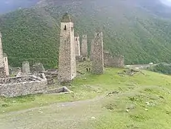 Defense towers in the selo of Erzi in Dzheyrakhsky District | |

Location of Dzheyrakhsky District in the Republic of Ingushetia | |
| Coordinates: 42°49′N 44°41′E | |
| Country | Russia |
| Federal subject | Republic of Ingushetia[1] |
| Established | October 1993[2] |
| Administrative center | Dzheyrakh[1] |
| Area | |
| • Total | 628.14 km2 (242.53 sq mi) |
| Population | |
| • Total | 2,638 |
| • Estimate (2018)[4] | 2,981 (+13%) |
| • Density | 4.2/km2 (11/sq mi) |
| • Urban | 0% |
| • Rural | 100% |
| Administrative structure | |
| • Inhabited localities | 85 Rural localities |
| Municipal structure | |
| • Municipally incorporated as | Dzheyrakhsky Municipal District[5] |
| • Municipal divisions[5] | 0 Urban settlements, 5 Rural settlements |
| Time zone | UTC+3 (MSK |
| OKTMO ID | 26620000 |
| Website | http://www.jeyrah.ru |
| 2010 Census | 2,638[1] |
|---|---|
| 2002 Census | 2,334[7] |
History
The district was established in October 1993.[2]
Administrative structure
| Number | Rural settlement | Administrative center | Number of localities | Population (2016) |
|---|---|---|---|---|
| 1 | Dzheyrakh rural settlement | selo Dzheyrakh | 6 | 1939 [8] |
| 2 | Beyni rural settlement | selo Beyni | 6 | 89 |
| 3 | Guly rural settlement | selo Guly | 60 | 244 |
| 4 | Lyazhgi rural settlement | selo Lyazhgi | 5 | 275 |
| 5 | Olgetti rural settlement | Olgetti | 8 | 336 |
Administrative and municipal status
Within the framework of administrative divisions, Dzheyrakhsky District is one of the four in the Republic of Ingushetia[1] and has administrative jurisdiction over all of its eighty-five rural localities. As a municipal division, the district is incorporated as Dzheyrakhsky Municipal District.[5] Its eighty-five rural localities are incorporated into five rural settlements within the municipal district.[5] The selo of Dzheyrakh serves as the administrative center of both the administrative[1] and municipal[5] district.
Culture
The Dzheyrakh-Assin historical and architectural museum and nature reserve, including Tkhaba-Yerdy Church, is located in the district.
References
Notes
- Russian Federal State Statistics Service (2011). "Всероссийская перепись населения 2010 года. Том 1" [2010 All-Russian Population Census, vol. 1]. Всероссийская перепись населения 2010 года [2010 All-Russia Population Census] (in Russian). Federal State Statistics Service.
- Official website of Dzheyrakhsky District (in Russian)
- Official website of the Republic of Ingushetia. Dzheyrakhsky District: Yesterday, Today, Tomorrow (in Russian)
- "26. Численность постоянного населения Российской Федерации по муниципальным образованиям на 1 января 2018 года". Federal State Statistics Service. Retrieved January 23, 2019.
- Law #5-RZ
- "Об исчислении времени". Официальный интернет-портал правовой информации (in Russian). June 3, 2011. Retrieved January 19, 2019.
- Russian Federal State Statistics Service (May 21, 2004). "Численность населения России, субъектов Российской Федерации в составе федеральных округов, районов, городских поселений, сельских населённых пунктов – районных центров и сельских населённых пунктов с населением 3 тысячи и более человек" [Population of Russia, Its Federal Districts, Federal Subjects, Districts, Urban Localities, Rural Localities—Administrative Centers, and Rural Localities with Population of Over 3,000] (XLS). Всероссийская перепись населения 2002 года [All-Russia Population Census of 2002] (in Russian).
- Population of Russian Federation by municipal divisions of January, 1, 2016
Sources
- Народное Собрание Республики Ингушетия. Закон №5-РЗ от 23 февраля 2009 г. «Об установлении границ муниципальных образований Республики Ингушетия и наделении их статусом сельского поселения, муниципального района и городского округа», в ред. Закона №9-РЗ от 4 марта 2014 г. «О внесении изменений в Закон Республики Ингушетия "Об установлении границ муниципальных образований Республики Ингушетия и наделении их статусом сельского поселения, муниципального района и городского округа"». Вступил в силу со дня официального опубликования. Опубликован: "Ингушетия", №26–27, 3 марта 2009 г. (People's Assembly of the Republic of Ingushetia. Law #5-RZ of February 23, 2009 On Establishing the Borders of the Municipal Formations of the Republic of Ingushetia and on Granting Them the Status of a Rural Settlement, Municipal District, and Urban Okrug, as amended by the Law #9-RZ of March 4, 2014 On Amending the Law of the Republic of Ingushetia "On Establishing the Borders of the Municipal Formations of the Republic of Ingushetia and on Granting Them the Status of a Rural Settlement, Municipal District, and Urban Okrug". Effective as of the day of the official publication.).
Administrative divisions of the Republic of Ingushetia | |||
|---|---|---|---|
| Districts | |||
| Cities and towns | |||
