Eagle Creek (Multnomah County, Oregon)
Eagle Creek is a creek located in Hood River County, Oregon, in the Columbia River Gorge. A tributary of the Columbia River, the creek flows for approximately 15 miles (24 km) from the Thrush Pond between Eagle Butte and Tanner Butte to its mouth near Bonneville Dam. The East Fork Eagle Creek is a major tributary that begins at Wahtum Lake and joins the main stem approximately 2/3 the way between the Thrush Pond and the Columbia River, separated by Indian Mountain.
| Eagle Creek | |
|---|---|
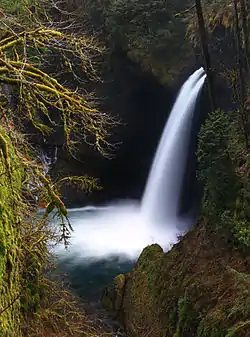 Metlako Falls on Eagle Creek | |
 Location of the mouth of Eagle Creek in Oregon | |
| Location | |
| Country | United States |
| State | Oregon |
| County | Hood River County |
| Physical characteristics | |
| Source | |
| • location | Thrush Pond near Eagle Butte |
| • coordinates | 45°32′58″N 121°54′15″W[1] |
| • elevation | 3,455 feet (1,053 m) |
| 2nd source | |
| • location | Wahtum Lake |
| • coordinates | 45°34′52″N 121°47′56″W[2] |
| • elevation | 3,727 feet (1,136 m) |
| Mouth | Columbia River east of Bonneville Dam |
• location | Oregon |
• coordinates | 45°35′26″N 121°55′57″W[1] |
• elevation | 79 feet (24 m) |
| Basin features | |
| Progression | Eagle Creek → Columbia River → Pacific Ocean |
Drainage basin
The Eagle Creek drainage basin is the largest of any creek in the western or central Gorge. The watershed is bounded by Tanner Ridge to the west, the Benson Plateau and Chinidere Mountain to the east, and Indian Mountain and Waucoma Ridge to the south. Another major tributary is Opal Creek, flowing from Tanner Butte to just above Tenas Falls.
Waterfalls
Eagle creek is notable for its numerous waterfalls. From the mouth upstream, the most notable are Metlako Falls, Punch Bowl Falls, Skoonichuk Falls, Grand Union Falls, Twister Falls, and Sevenmile Falls. Noteworthy waterfalls on Eagle Creek's many tributaries include Sorenson Falls, Loowit Falls, Four Mile Falls, Tenas Falls, Wy'east Falls, and Tunnel Falls.
Recreation
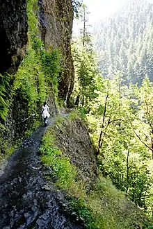
Eagle Creek is an extremely popular recreation destination. The Eagle Creek Trail #440 runs for 13.1 miles (21.1 km) along the creek from the Historic Columbia River Highway State Trail to a junction with the Pacific Crest Trail near Wahtum Lake, and its lower reaches comprise one of the most popular trails in the Gorge. Multiple other trails are also present on the surrounding ridges and mountains, providing connections to the rest of the Gorge's trail network.[3]
History
The Eagle Creek watershed was severely impacted the Eagle Creek Fire of 2017, which started near Punch Bowl Falls after a 15-year old kid threw a firecracker into the canyon following a prolonged period without precipitation. Due to the increased risk of landslides, debris flows, and other hazards, recreation in the area remains closed as of January 2019.[4]
References
- "Eagle Creek". Geographic Names Information System. United States Geological Survey (USGS). November 28, 1980. Retrieved January 10, 2019.
- "East Fork Eagle Creek". Geographic Names Information System. United States Geological Survey (USGS). November 28, 1980. Retrieved January 10, 2019.
- "Eagle Creek Trail #440". United States Forest Service. Retrieved January 10, 2019.
- "Columbia River Gorge National Scenic Area: Burned Area Emergency Response Summary – Eagle Creek Fire" (PDF). United States Forest Service. Retrieved January 10, 2019.
