Earlville, Iowa
Earlville is a city in Delaware County, Iowa, United States. The population was 812 at the 2010 census.
Earlville, Iowa | |
|---|---|
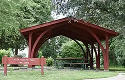 Ruth Suckow Park | |
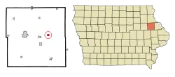 Location of Earlville, Iowa | |
| Coordinates: 42°28′55″N 91°16′14″W | |
| Country | |
| State | |
| County | Delaware |
| Area | |
| • Total | 0.56 sq mi (1.46 km2) |
| • Land | 0.56 sq mi (1.46 km2) |
| • Water | 0.00 sq mi (0.00 km2) |
| Elevation | 997 ft (304 m) |
| Population | |
| • Total | 812 |
| • Estimate (2019)[3] | 772 |
| • Density | 1,371.23/sq mi (528.97/km2) |
| Time zone | UTC-6 (Central (CST)) |
| • Summer (DST) | UTC-5 (CDT) |
| ZIP code | 52041 |
| Area code(s) | 563 |
| FIPS code | 19-23430 |
| GNIS feature ID | 0456106 |
History
Earlville got its start in the year 1857, following construction of the railroad through that territory. It is named for its first settler, George M. Earl.[4][5]
Geography
Earlville is located at 42°28′55″N 91°16′14″W (42.482074, -91.270456).[6]
According to the United States Census Bureau, the city has a total area of 0.55 square miles (1.42 km2), all land.[7]
Demographics
| Year | Pop. | ±% |
|---|---|---|
| 1890 | 569 | — |
| 1900 | 618 | +8.6% |
| 1910 | 552 | −10.7% |
| 1920 | 619 | +12.1% |
| 1930 | 615 | −0.6% |
| 1940 | 687 | +11.7% |
| 1950 | 661 | −3.8% |
| 1960 | 668 | +1.1% |
| 1970 | 751 | +12.4% |
| 1980 | 844 | +12.4% |
| 1990 | 822 | −2.6% |
| 2000 | 900 | +9.5% |
| 2010 | 812 | −9.8% |
| 2019 | 772 | −4.9% |
| Source:"U.S. Census website". United States Census Bureau. Retrieved 2020-03-29. and Iowa Data Center Source: | ||
2010 census
As of the census[2] of 2010, there were 812 people, 331 households, and 236 families residing in the city. The population density was 1,476.4 inhabitants per square mile (570.0/km2). There were 354 housing units at an average density of 643.6 per square mile (248.5/km2). The racial makeup of the city was 98.6% White, 0.1% Asian, 0.6% from other races, and 0.6% from two or more races. Hispanic or Latino of any race were 2.5% of the population.
There were 331 households, of which 31.1% had children under the age of 18 living with them, 59.2% were married couples living together, 7.6% had a female householder with no husband present, 4.5% had a male householder with no wife present, and 28.7% were non-families. 24.2% of all households were made up of individuals, and 11.8% had someone living alone who was 65 years of age or older. The average household size was 2.45 and the average family size was 2.90.
The median age in the city was 42.3 years. 23.8% of residents were under the age of 18; 6.2% were between the ages of 18 and 24; 23.7% were from 25 to 44; 28.5% were from 45 to 64; and 17.6% were 65 years of age or older. The gender makeup of the city was 49.9% male and 50.1% female.
2000 census
As of the census[9] of 2000, there were 900 people, 338 households, and 248 families residing in the city. The population density was 1,648.0 people per square mile (631.8/km2). There were 355 housing units at an average density of 650.0 per square mile (249.2/km2). The racial makeup of the city was 98.78% White, 0.11% African American, 0.33% Native American, 0.22% Asian, 0.33% from other races, and 0.22% from two or more races. Hispanic or Latino of any race were 1.11% of the population.
There were 338 households, out of which 36.7% had children under the age of 18 living with them, 60.4% were married couples living together, 8.3% had a female householder with no husband present, and 26.6% were non-families. 21.9% of all households were made up of individuals, and 13.0% had someone living alone who was 65 years of age or older. The average household size was 2.66 and the average family size was 3.13.
In the city, the population was spread out, with 30.0% under the age of 18, 7.3% from 18 to 24, 27.9% from 25 to 44, 18.8% from 45 to 64, and 16.0% who were 65 years of age or older. The median age was 37 years. For every 100 females, there were 98.7 males. For every 100 females age 18 and over, there were 97.5 males.
The median income for a household in the city was $38,194, and the median income for a family was $43,333. Males had a median income of $30,398 versus $20,625 for females. The per capita income for the city was $14,855. About 6.0% of families and 6.6% of the population were below the poverty line, including 6.7% of those under age 18 and 8.1% of those age 65 or over.
Education
The Maquoketa Valley Community School District operates local area public schools.[10] St. Joseph School, under the Roman Catholic Archdiocese of Dubuque, was in Earlville.[11]
References
- "2019 U.S. Gazetteer Files". United States Census Bureau. Retrieved July 17, 2020.
- "U.S. Census website". United States Census Bureau. Retrieved 2012-05-11.
- "Population and Housing Unit Estimates". United States Census Bureau. May 24, 2020. Retrieved May 27, 2020.
- Gannett, Henry (1905). The Origin of Certain Place Names in the United States. Govt. Print. Off. pp. 112.
- The History of Delaware County, Iowa: Containing a History of the County, Its Cities, Towns, &c. Western Historical Company. 1878. pp. 520.
- "US Gazetteer files: 2010, 2000, and 1990". United States Census Bureau. 2011-02-12. Retrieved 2011-04-23.
- "US Gazetteer files 2010". United States Census Bureau. Archived from the original on 2012-07-02. Retrieved 2012-05-11.
- "Census of Population and Housing". Census.gov. Retrieved June 4, 2015.
- "U.S. Census website". United States Census Bureau. Retrieved 2008-01-31.
- "MAQUOKETA VALLEY" (PDF). Iowa Department of Education. Retrieved 2020-08-24.
- "EDUCATION AND FORMATION PERSONNEL". Roman Catholic Archdiocese of Dubuque. 2000-09-15. Archived from the original on 2000-09-15. Retrieved 2020-04-06.
Municipalities and communities of Delaware County, Iowa, United States | ||
|---|---|---|
| Cities | Map of Iowa highlighting Delaware County | |
| Townships | ||
| Unincorporated communities | ||
| Footnotes | ‡This populated place also has portions in an adjacent county or counties | |
| ||