El Cañaveral
El Cañaveral is an administrative neighborhood of Madrid, belonging to the district of Vicálvaro. Created in November 2017 after the passing of the new internal organization of the district on 31 October 2017 by the plenary of the Madrid City Council,[1] it is named after the PAU ("Program of Urban Action") in the area, which unlike the administrative neighborhood does not extend to the east of the Cañada Real linear shanty town, as the administrative neighborhood also currently comprises the future development of Los Cerros,[2] another PAU. The first neighbors of the PAU installed in 2016.[3] As of 1 March 2020, the neighborhood has a population of 2,565.[4]
El Cañaveral | |
|---|---|
.JPG.webp) | |
 | |
| Country | Spain |
| Region | Community of Madrid |
| Municipality | Madrid |
| District | Vicálvaro |
| Population (2020) | |
| • Total | 2,565 |
Once the PAU is fully built it is expected to feature 14,000 housing units.[5] In addition, Los Cerros is tentatively expected to feature 15,000 housing units.[5]
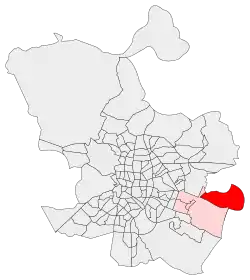
The neighborhood is roughly delimitated by the C-2/C-7 commuter railroads, the R-3, and the municipal borders with Rivas-Vaciamadrid, San Fernando de Henares and Coslada.[n. 1]
References
- Informational notes
- "Confluencia a distinto nivel de la vía de ferrocarril de cercanías C2 y C7 y la autopista R-3, autopista R-3 en dirección Sureste y Este hasta la cañada Real de Merinas, cañada Real de Merinas dirección Sur hasta su encuentro con la línea de separación de los términos de Madrid y Rivas-Vaciamiadrid, línea límite municipal en dirección Este, Norte y Oeste con los términos de Rivas-Vaciamadrid, San Fernando de Henares y Coslada, intersección de la línea de separación de municipios de Madrid y Coslada entre los mojones M155 y M156 con la vía del ferrocarril de cercanías C2 y C7, vía ferroviaria de cercanías C2 y C7 dirección Suroeste hasta su confluencia con la autopista R-3."[1]
- Citations
- Ayuntamiento de Madrid: "Acuerdo del Pleno, de 31 de octubre de 2017, por el que se aprueba la creación de los barrios "Casco Histórico de Vicálvaro", "Valdebernardo", "Valderrivas" y "El Cañaveral" y la delimitación territorial interna actualizada del Distrito de Vicálvaro, así como el cambio de denominación del "Barrio de San Andrés" por el de "Villaverde Alto, Casco Histórico de Villaverde" y la delimitación territorial interna actualizada del distrito de Villaverde, junto con la correspondiente modificación del Reglamento Orgánico de los Distritos de la Ciudad de Madrid" (PDF). Boletín Oficial de la Comunidad de Madrid: 119. 17 November 2017. ISSN 1989-4791.
- "Madrid suma 131 barrios con Valdebernardo, Valderrivas y El Cañaveral". Diario Madrid. Ayuntamiento de Madrid. 10 November 2017.
- Peinado, Fernando (7 January 2020). "Primero el negocio y luego las personas en el barrio más nuevo de Madrid". El País.
- "Población por distrito y barrio". Ayuntamiento de Madrid. Retrieved 20 March 2020.
- Sanz, Elena (22 January 2016). "El Madrid 'pobre' despierta del coma inmobiliario: hay vida más allá del Cañaveral". El Confidencial.