Elbert, Colorado
Elbert is an unincorporated town, a post office, and a census-designated place (CDP) located in and governed by Elbert County, Colorado, United States. The CDP is a part of the Denver–Aurora–Lakewood, CO Metropolitan Statistical Area. The Elbert post office has the ZIP Code 80106.[3] At the United States Census 2010, the population of the Elbert CDP was 230, while the population of the 80106 ZIP Code Tabulation Area was 4,232 including adjacent areas.[4]
Elbert, Colorado | |
|---|---|
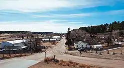 Elbert, Colorado. | |
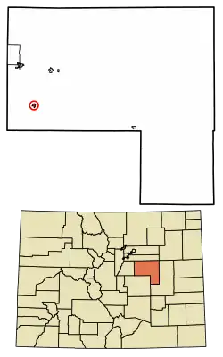 Location of the Elbert CDP in Elbert County, Colorado. | |
 Elbert Location of the Elbert CDP in the United States. | |
| Coordinates: 39°13′08″N 104°32′26″W[1] | |
| Country | |
| State | |
| County | Elbert County |
| Government | |
| • Type | unincorporated community |
| Area | |
| • Total | 0.474 sq mi (1.227 km2) |
| • Land | 0.474 sq mi (1.227 km2) |
| • Water | 0.000 sq mi (0.000 km2) |
| Elevation | 6,840 ft (2,085 m) |
| Population (2010) | |
| • Total | 230 |
| • Density | 485/sq mi (187/km2) |
| Time zone | UTC-7 (MST) |
| • Summer (DST) | UTC-6 (MDT) |
| ZIP Code[3] | 80106 |
| Area codes | 303 & 720 |
| GNIS feature[2] | Elbert CDP |
History
The Elbert post office has been in operation since 1875.[5] The community takes its name from Elbert County.[6]
The most significant flood events in Elbert County occurred in 1935, 1965, 1997, and 1999. The most damaging flood was in 1935, when flooding on Kiowa Creek destroyed three-fourths of the structures location in Elbert and resulted in nine deaths, seven of them in Elbert.[7] All bridges were lost, 59 buildings were destroyed, water was 8 to 15 feet (2.4 to 4.6 m) deep, and there were 5 feet (1.5 m) of sand. Three-fourths of the town of Elbert was destroyed and not rebuilt.[8]
On 11 January 1998 a fireball was seen over Elbert County. On 4 March 2000 a stone of 680.5 g was found in a field by the five year old Dustin Riffel on the property of his family. It was officially named "Elbert" and it was classified as an ordinary chondrite LL6.[9]
On June 15, 2009, at 1:46 pm, a large three quarter mile-wide, EF2 tornado touched down in rural fields west of the town. The tornado came within 2 miles (3 km) of the town at its closest. The tornado destroyed a barn at a farm and damaged an airplane hangar.[10]
Today
In Elbert today you can find a small community with a lot of ranchers and farmers. The Elbert School was rebuilt and is one of the nicest schools in the state of Coloroado.
Geography
Elbert is located in the valley of Kiowa Creek. Elbert Road leads north 10 miles (16 km) to Kiowa and south 11 miles (18 km) to Eastonville. Colorado Springs is 37 miles (60 km) to the southwest via Elbert Road and U.S. Route 24.
During the summer, Elbert is much busier due to a nearby Boy Scout camp, Peaceful Valley Scout Ranch, which has 10,000 visitors annually. 2.8 miles (4.5 km) south of Elbert lies the JCC Ranch Camp, a Jewish camp owned by the Denver Jewish Community Center.
The Elbert CDP has an area of 303 acres (1.227 km2), all land.[1]
Demographics
The United States Census Bureau initially defined the Elbert CDP for the United States Census 2010.
| Year | Pop. | ±% |
|---|---|---|
| 2010 | 230 | — |
| 2020 | — | |
| Source: United States Census Bureau | ||
Transportation
Elbert lies along Elbert Road, which connects the town of Kiowa to U.S. Highway 24. The largest nearby city is Castle Rock, which is about 45 minutes away via SH 86, which Elbert Road crosses at Kiowa. Colorado Springs is an hour drive via US 24.
See also
- Outline of Colorado
- State of Colorado
- Colorado cities and towns
- Colorado counties
- Colorado metropolitan areas
References
- "State of Colorado Census Designated Places - BAS20 - Data as of January 1, 2020". United States Census Bureau. Retrieved December 22, 2020.
- "U.S. Board on Geographic Names: Domestic Names". United States Geological Survey. Retrieved December 22, 2020.
- "Look Up a ZIP Code". United States Postal Service. Retrieved December 22, 2020.
- "2010: DEC Summary File 1". United States Census Bureau. Retrieved December 22, 2020.
- "Post offices". Jim Forte Postal History. Archived from the original on 6 March 2016. Retrieved 25 June 2016.
- Dawson, John Frank. Place names in Colorado: why 700 communities were so named, 150 of Spanish or Indian origin. Denver, CO: The J. Frank Dawson Publishing Co. p. 19.
- "Archived copy". Archived from the original on 2016-01-24. Retrieved 2020-03-29.CS1 maint: archived copy as title (link)
- http://www.dhsem.state.co.us/sites/default/files/Elbert%20County%204.2010.pdf
- Meteoritical Bulletin Database: Elbert
- "Archived copy". Archived from the original on 2009-06-18. Retrieved 2009-06-16.CS1 maint: archived copy as title (link)
External links
- Elbert @ Colorado.com
- Elbert @ UncoverColorado.com
- Elbert School District
- Elbert Community Bulletin Board
- Elbert County website
- Elbert County Community Homepage
Municipalities and communities of Elbert County, Colorado, United States | ||
|---|---|---|
| Towns | 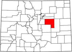 Map of Colorado highlighting Elbert County | |
| CDP | ||
| Unincorporated communities | ||
| ||