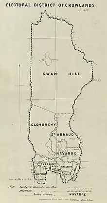
Electoral district of Crowlands
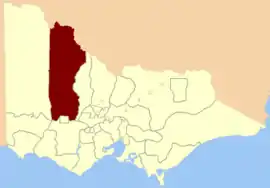
Crowlands was an electoral district of the Legislative Assembly[1] in the Australian colony of Victoria from 1859 to 1877. It was located in north-western Victoria and included the town of Swan Hill.[2]

| Crowlands Victoria—Legislative Assembly | |
|---|---|
 Location in Victoria | |
| State | Victoria |
| Created | 1859 |
| Abolished | 1877 |
| Demographic | Rural |
The district was defined as being:
Bounded on the west by the Yarriambiack Creek from the junction of the River Wimmera to Lake Corong; thence by a line north to the Murray; again on the west by a tributary of the River Wimmera to its source near Briggs's Bluff in the Grampians; thence southwards by the Grampians range; on the south by the Dividing Range; on the east by the River Avoca and a line north to the Murray; and on the north by the Murray, excepting the country included within the electoral district of Ararat.
Members
| 2 members[3] | |||||
|---|---|---|---|---|---|
| Member 1 | Term | Member 2 | Term | ||
| John Houston | Oct 1859 – Dec 1865 | John Woods | Oct 1859 – Aug 1864 | ||
| Ronald Campbell | Nov 1864 – Dec 1865 | ||||
| Robert Byrne | Feb 1866 – Oct 1869 | Andrew Love | Feb 1866 – Dec 1867 | ||
| David Blair | Mar 1868 – Jan 1871 | ||||
| George Rolfe | Oct 1869[b] – Jan? 1871 | ||||
| Robert Walker | Apr 1871 – Mar 1874 | John Woods | Apr 1871 – Apr 1877 | ||
| Colin Campbell | May 1874 – Apr 1877 | ||||
- [b] = by-election
After Crowlands was abolished, John Woods went on to represent the Electoral district of Stawell from its creation in 1877 to 1892.[1]
References
- "Re-Member (Former Members)". State Government of Victoria. Retrieved 12 April 2013.
- "Electoral district of Crowlands" (map). 1863. Retrieved 19 April 2013.
- "An Act to alter the Electoral Districts of Victoria and to increase the number of Members of the Legislative Assembly thereof" (PDF). 1858. Retrieved 24 April 2013.