Electoral division of Derwent
The electoral division of Derwent is one of the 15 electoral divisions in the Tasmanian Legislative Council. It is situated in the central south of the state.
| Derwent Tasmania—Legislative Council | |
|---|---|
| State | Tasmania |
| Created | 1871 |
| MP | Craig Farrell |
| Party | Labor Party |
| Namesake | Derwent River |
| Electors | 25,637 (2019) |
| Area | 12,184 km2 (4,704.3 sq mi) |
| Coordinates | 41.47°S 146.16°E |
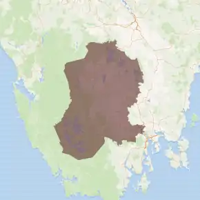
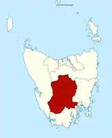
The last boundary redistribution occurred in 2017. The total area of the division is 12,184 square kilometres (4,704 sq mi).
As of 31 January 2019, there were 25,637 enrolled voters in the division.[2] The next election in the division is due in May 2021.
The division is named after the Derwent River and includes the Central Highlands and Derwent Valley local government areas, as well as some outer Hobart suburbs such as Bridgewater, Chigwell, Claremont, and towns such as Bothwell, Hamilton, Maydena, New Norfolk, and Westerway.
Members
| Member | Party | Term | |
|---|---|---|---|
| William Langdon | Independent | 1856–1871 | |
| Walter Gellibrand | Independent | 1871–1901 | |
| Ellis Dean | Independent | 1901–1920 | |
| Louis Shoobridge | Independent | 1921–1937 | |
| (Sir) Rupert Shoobridge | Independent | 1937–1955 | |
| Joseph Dixon | Independent | 1955–1961 | |
| Don Marriott | Labor | 1961–1967 | |
| Joseph Dixon | Independent | 1967–1979 | |
| Charles Batt | Labor | 1979–1995 | |
| Michael Aird | Labor | 1995–2011 | |
| Craig Farrell | Labor | 2011–present | |
See also
References
- Legislative Council Divisions (2016-17 redistribution) from theLIST ©State of Tasmania (Creative Commons Attribution 3.0 Australia Licence).
- Legislative Council Enrolment as at 31 January 2019, Tasmanian Electoral Commission, 6 February 2019.
This article is issued from Wikipedia. The text is licensed under Creative Commons - Attribution - Sharealike. Additional terms may apply for the media files.