Electoral regions of Western Australia
The Western Australian Legislative Council is elected from six multi-member electoral regions, which are in turn composed of electoral districts which are used to elect the Legislative Assembly. The current number of electoral regions was established on 22 May 1989.[1] Initially, the South West and Northern Metropolitan regions returned seven members to the Legislative Council, while the other regions each returned five members.[1] This arrangement was changed to have each region return six members[2] for the 2008 Western Australian election, increasing the total number of members from 34 to 36. Before 1989 electoral divisions for the Legislative Council were known as electoral provinces.
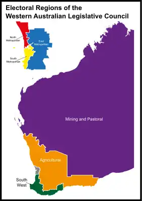
The boundaries of electoral regions that applied to the 2017 State election were finalised in November 2015 by the Western Australian Electoral Commission.[3][4]
Current electoral regions
The current electoral regions structure was created in 1989. Initially, the South West and Northern Metropolitan regions returned seven members to the Legislative Council, while the other regions each returned five members.[1] This arrangement was changed to have each region return six members[2] for the 2008 Western Australian election. A redistribution of boundaries of and divisions in regions took place in 2015.[3] These changes were in effect for the 2017 State election held on 11 March 2017.
| Name | Est. | Area (2017)[5] | Electors (2017) | № Legislative Assembly districts (2017)[3] | Current seat distribution (2021) | |||||
|---|---|---|---|---|---|---|---|---|---|---|
| Agricultural | 1989 | 281,264 km2 (108,597 sq mi) | 101,229 | 4 | ||||||
| East Metropolitan | 1989 | 3,697 km2 (1,427 sq mi)* | 362,932 | 14 | ||||||
| Mining and Pastoral | 1989 | 2,200,083 km2 (849,457 sq mi) | 96,894 | 4 | ||||||
| North Metropolitan | 1989 | 929 km2 (359 sq mi)* | 362,608 | 14 | ||||||
| South Metropolitan | 1989 | 754 km2 (291 sq mi)* | 377,634 | 15 | ||||||
| South West | 1989 | 44,870 km2 (17,320 sq mi) | 205,270 | 8 | ||||||
| Total | 1,506,567 | 59 | ||||||||
Note: The metropolitan regions (marked *) use the 2013 area information.
The structure of the regions prior to the 2015 redistribution was as follows:
| Name | Est. | Area (2013) | № Legislative Assembly districts (2013) | Distribution of seats (2013) | |||||
|---|---|---|---|---|---|---|---|---|---|
| Agricultural | 1989 | 200,091 km2 (77,256 sq mi) | 4 | ||||||
| East Metropolitan | 1989 | 3,697 km2 (1,427 sq mi) | 14 | ||||||
| Mining and Pastoral | 1989 | 2,280,730 km2 (880,590 sq mi) | 5 | ||||||
| North Metropolitan | 1989 | 929 km2 (359 sq mi) | 14 | ||||||
| South Metropolitan | 1989 | 754 km2 (291 sq mi) | 14 | ||||||
| South West | 1989 | 41,008 km2 (15,833 sq mi) | 8 | ||||||
| Total | 59 | ||||||||
Legend:
| Labor | Liberal | National | Greens | Shooters and Fishers |
Former electoral provinces
Before 1989 electoral divisions for the Legislative Council were known as electoral provinces. The Constitution Acts Amendment Act (No.2) 1963, effective from the 1965 state election, abolished the ten existing three-member provinces, replacing them with 15 two-member provinces. One new province was added at the 1977 state election. Some of the new provinces bore the same names as the previous provinces.
Metropolitan
| Name | Est. | Abolished | № of members | Notes |
|---|---|---|---|---|
| East Metropolitan | 1977 | 1983 | 2 | |
| Metropolitan | 1894 | 1989 | 3 (1894–1965) 2 (1965–89) | |
| Suburban known as Metropolitan-Suburban Province from 1900–50. | 1900 | 1965 | 3 | |
| North Central Metropolitan | 1983 | 1989 | 2 | |
| North-East Metropolitan | 1965 | 1989 | 2 | |
| North Metropolitan | 1965 | 1989 | 2 | |
| South Central Metropolitan | 1983 | 1989 | 2 | |
| South-East Metropolitan | 1965 | 1989 | 2 | |
| South Metropolitan | 1965 | 1989 | 2 |
References
- Acts Amendment (Electoral Reform) Act 1987
- Electoral Amendment and Repeal Act 2005 (No.1 of 2005)
- 2015 Final Boundaries by Region and District
- Electoral Act 1907
- "Archived copy". Archived from the original on 2017-02-11. Retrieved 2017-03-20.CS1 maint: archived copy as title (link)