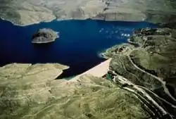
Elephant Butte Reservoir
Elephant Butte Reservoir is a reservoir on the Rio Grande in the U.S. state of New Mexico, 5 miles (8.0 km) north of Truth or Consequences. This reservoir is the 84th largest man-made lake in the United States, and the largest in New Mexico by total surface area and peak volume. It is the only place in New Mexico where one can find pelicans perched on or alongside the lake. There are also temporary US Coast Guard bases stationed at Elephant Butte. It is impounded by Elephant Butte Dam and is part of the largest state park in New Mexico, Elephant Butte Lake State Park.[1]
| Elephant Butte Reservoir | |
|---|---|
 Elephant Butte Reservoir and Dam | |
 Elephant Butte Reservoir  Elephant Butte Reservoir | |
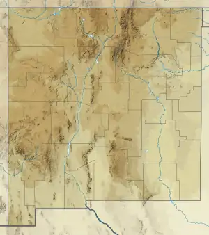
| Location | Sierra County, New Mexico |
| Coordinates | 33°14′19.43″N 107°10′26.23″W |
| Lake type | Hydroelectric reservoir |
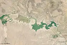
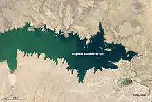
| Primary inflows | Rio Grande |
| Primary outflows | Rio Grande |
| Basin countries | United States |
| Surface area | 36,500 acres (14,800 ha) |
| Water volume | 2,065,010 acre⋅ft (2.54715 km3) |
| Surface elevation | 4,414 ft (1,345 m) |
The reservoir is part of the Rio Grande Project, a project to provide power and irrigation to south-central New Mexico and west Texas. It was filled starting between 1915 and 1916, and at highstand was the largest man-made lake in the world.[2][3]
The reservoir can hold 2,065,010 acre feet (2.54715×10⁹ m3) of water[2] from a drainage of 28,900 square miles (74,850 km²).[4] It provides irrigation to 178,000 acres (720 km²) of land.[2]
Fishing is a popular recreational activity on the reservoir, which contains striped bass, white bass, largemouth bass, crappie, walleye and catfish.
Etymology
The reservoir was named after its dam, and refers to a volcanic core, "Elephant Butte", similar to Devils Tower in Wyoming. It is now an island in the lake when water levels are high. The butte was said to have the shape of an elephant lying on its side.
Dam construction and history
The proposed dam featured in the 1906 Boundary Waters Convention between the United States and Mexico, which specified how much water should be delivered to Mexico following the dam's completion.[5]
Elephant Butte Dam, constructed between 1911 and 1916, with the reservoir fill started in 1915, was a major engineering feat in its day. The enormous concrete dam is the major feature of the Elephant Butte National Register Historic District. New Mexico State Parks operates a visitor center that contains information on the construction of the dam. It stood as the second largest irrigation dam ever built at the time of its construction, only being surpassed in 1970 by the Aswan Dam in Egypt, and the reservoir was the largest man made lake on earth.[3]
A large construction community sprang up, which included two worker camps, railways, water tanks, cableway systems, and the former administration building of the Bureau of Reclamation. The "camps" housed American and Mexican workers throughout the construction of the dam. One the former camps ended up under the reservoir itself; the other disappeared altogether. Moreover, many centuries-old communities and farming villages were "obliterated" by the filling of the reservoir and now lie at the bottom, including complete stone structures. Over 2,000 people were displaced by the filling of the reservoir.[3]
According to historical lake level data, the lake experienced highstand for the first time in 1944. This was the deepest higstand on record and stained the inundated landscape white with gypsum and other minerals, and deposited sediments in the surrounding hills. By 1950, the water levels were well below the initial 1915 levels. Another, longer lived highstand occurred from 1986 to 1999, with a relatively lower highstand in 1991-92. Most of the photographs showing a relatively full lake are from this time.[6]
American kidnapper and torturer David Parker Ray tortured his victims in his "toy box" trailer near the reservoir between 1950 and 1999. He is suspected of killing his victims and disposing of the bodies in the lake, although one survivor he thought he killed was left near the US-Mexico boarder. Officials have conducted searches at the lake, but have not found any human remains anywhere related to Ray.[3]
The former administration building of the Bureau of Reclamation still stands as a bed and breakfast facility, and, along with other structures of the time, are listed in the National Register of Historic Places.[7] When the lake falls over 10 meters (30 feet) below maximum capacity, the ruins of the old machine shop and power plant are out of the water.[8] Located near the south-east shore, this 3000 square-foot concrete structure was once believed to be the remnants of the old field hospital that served the frequently injured dam construction crew. That building is located further upstream in the aptly named 'Hospital Canyon'. Plans are underway to make the machine shop ruins a scuba destination in years of high water-level.[9]
In 2014, a group celebrating a bachelor party on the exposed sediments of the lake discovered the head and tusks of a 3.2 million year old stegomastodon, a relative of actual elephants, in excellent condition. this is one of the most complete finds of a stegomastodon in the area. The skull is on display at the New Mexico Museum of Natural History and Science.[3]
Image Gallery
 Panoramic view of Elephant Butte Reservoir in 2005
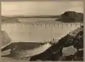 The dam at Elephant Butte Reservoir in 1916, before the 1944 highstand.
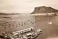 Elephant Butte Reservoir in 1946 after the highstand. Note the mineral stains on the hillsides created just two years prior.
References
- "Elephant Butte Reservoir". USDOI data. Bureau of Reclamation. May 1, 2004. Retrieved September 2, 2008.
- "Elephant Butte Powerplant". Rio Grande Project. Bureau of Reclamation. December 28, 2005. Archived from the original on September 26, 2006. Retrieved October 11, 2006.
- Briseño, Elaine D. (July 5, 2020). "Elephant Butte looks the part, but a long, storied history is at the center of how the dam got and kept its name". Albuquerque Journal. Retrieved February 2, 2021 – via abqjournal.com.
- "Elephant Butte Dam". Dataweb. Bureau of Reclamation. August 22, 2006. Retrieved October 11, 2006.
- https://www.ibwc.gov/Files/1906Conv.pdf text of 1906 Boundary Waters Convention
- "Elephant Butte Lake Water Data". Albuquerque Journal. February 1, 2021. Retrieved February 2, 2021 – via Water Data for Texas.
- "History of Elephant Butte". HHEB data. New Mexico Energy, Minerals, and Natural Resources Department. Aug 2, 2006. Retrieved February 21, 2012.
- "The Legend of the Hospital at the bottom of Elephant Butte Lake". SCNM. Sierra County, NM. February 10, 2013. Retrieved April 25, 2012.
- "Mystery Building of Elephant Butte". Jonsered. Urban Exploration Resource. September 25, 2009. Retrieved February 22, 2012.
External links
| Wikimedia Commons has media related to Elephant Butte Reservoir. |
- Elephant Butte Lake State Park
- Elephant Butte Chamber of Commerce
- Historic American Engineering Record (HAER) No. NM-20, "Elephant Butte Reservoir, Elephant Butte, Sierra County, NM", 3 data pages
| Authority control |
|
|---|