Elmwood, Holyoke, Massachusetts
Elmwood is a neighborhood in Holyoke, Massachusetts located to the south of the city center, approximately 1 mile (1.6 km) from downtown. Elmwood is historically Holyoke's oldest village; predating the construction of the Hadley Falls Dam, it originated as part of the 3rd parish ("Ireland Parish") of West Springfield, and originally was known as Baptist Village as Holyoke's first and oldest congregation is the First Baptist Church, formally established in 1803, but maintaining a meetinghouse since 1792.[3][4]:108 Today the neighborhood contains many historic Victorian houses and about 510 acres (210 ha) of mixed residential and commercial zoning, as well as Holyoke High School, William R. Peck Middle School, Fitzpatrick Ice Skating Rink, and Mackenzie Stadium.[1][3]
Elmwood | |
|---|---|
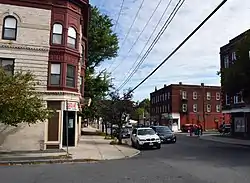 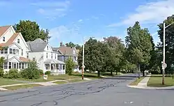 Top to bottom: Elmwood's commercial center, featuring blocks by George P. B. Alderman; neighborhood homes across from Laurel Park | |
 Elmwood  Elmwood  Elmwood | |
| Coordinates: 42°11′45.33″N 72°37′28.32″W | |
| Country | United States |
| State | Massachusetts |
| City | Holyoke |
| Wards | 3 |
| Precincts | 3A, 3B |
| Area | |
| • Total | 0.798 sq mi (2.07 km2) |
| Elevation | 253 ft (77 m) |
| ZIP code | 01040 |
| Area code(s) | 413 |
| GNIS feature ID | 609000[2] |
| MACRIS ID | HLY.D |
History
.png.webp)
Colonial settlement
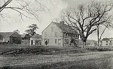
Baptist Village's origins as a village can be traced to 1725, when the first 5 people were baptized by the pastor of the First Baptist Church of Boston in the Connecticut River directly east of the Elmwood Cemetery, between what is now Ingleside and Springdale.[6]:13 With the village continually visited by a number of lay preachers in its earliest years, the community gained interest in building a house of worship prior to the incorporation of any formal church, the first Baptist Church being incorporated in 1803. In 1792 Baptist Village saw the construction of this first meetinghouse, known colloquially as the "Lord's barn", as funds ran out before its completion; it was described in the church's centennial history as "unsightly" and "excessively plain" in its first years.[4]:108 By 1801, the Congregationalists, having established their first church in the year prior, asked for use of the building in exchange for finishing it and adding permanent seating, to which the Baptists agreed. Before completion, the structure was moved northward to the west side of Northampton Street, just south of present-day Hitchcock Street, where the Blessed Sacrement and Metcalf Schools stand today.[4]
Among the earliest settlers of the village were the names Ely, Chapin, Day, Ball, Rand, Humeston, and Street, who built their homesteads in the vicinity of the Village. From its earliest days the area now identified between Brown Avenue and Northampton Street was occupied largely by the Ely family, among whom, Enoch Ely, was a soldier in the American Revolution. Following the war, Ely would take part in Shays' Rebellion to resist what he saw as unjust taxes upon the former patriot soldiers, and took to hiding in nearby woods to evade soldiers seeking his arrest. Unable to find him, they fired shots into the front door of his home; the bullet-ridden doors were kept on the home until at some point in the late 19th century. After several generations, the last of the Elys to occupy the homestead were "four spinster and bachelor brothers and sisters", and by some time in 1850s or 1860s, the homestead came into the ownership of Horace Brown, for whom Brown Avenue is so named today.[7]
Development
It was later recounted by one Mrs. Selma Kretschman that in the earliest days of German settlement during the 1860s and 1870s, Brown attempted to sell his land to one of the early settlers of the German community for $300, however not seeing the value of the land at that time, the gentleman turned down the offer saying "I couldn't keep a cow or a goat on the land. It's nothing but rattle boxes and brush".[8]
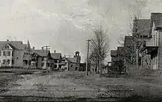
In the years following 1887, the neighborhood was developed when William S. Loomis purchased a large tract of land to the southeast of Northampton and South Street. With plans to develop this plot into residential tracts, he approached the board of the Holyoke Street Railway, at that time operating a small system of horsecars, who promptly rejected his calls for extending their lines to Elmwood. Through the cooperation of allies and purchase of company stock, Loomis purchased a controlling interest in the company, and immediately moved forward with plans for this construction. The neighborhood would see considerable growth in the following years when these lines were electrified, offering accessible mass transit between the area and many of the factories in which its residents worked.[9] Gradually the neighborhood, saw greater integration into Holyoke, as development continued outward from grid plan, and more workers could easily commute by foot making use of the streetcar, and subsequent bus system.[4]:77
References
| Wikimedia Commons has media related to Elmwood, Holyoke, Massachusetts. |
- Spatial analysis of "Holyoke Neighborhoods" (PDF). Archived from the original (PDF) on 2 August 2017. Retrieved 3 Jun 2016.
- "Elmwood, Holyoke, Massachusetts". Geographic Names Information System. United States Geological Survey. Retrieved 3 Jun 2016.
- "MACRIS inventory record for Elmwood, Holyoke". Commonwealth of Massachusetts. Retrieved 2014-06-18.
- Hungate, Jesse A. (1904). The History of the First Baptist Church of Holyoke, Mass; Together with the Proceedings of the Centennial Services. Holyoke, Mass. OCLC 7478801.
- "The Death of W. S. Loomis; His Many Holyoke Interests". Springfield Republican. Springfield, Mass. July 12, 1914. p. 2.
- Clark, Rusty (2006). Stories Carved in Stone: Holyoke, Massachusetts. West Springfield, Mass.: Dog Pond Press.
- Johnson, Fanny M. (October 1885). "A Model Industrial City". The Bay State Monthly. III (V): 328–340.
- Harper, Wyatt E. (1973). "German Settlers". The Story of Holyoke. Centennial Committee of the City of Holyoke. p. 84. OCLC 8060402.
- Cutter, William Richard; Crane, Ellery Bicknell; Gardner, Eugene C.; Read, Charles French; Ballard, Harland Hoge; Rantoul, Robert Samuel; Lockwood, John H.; Dyer, E. Alden (1916). Encyclopedia of Massachusetts, Biographical–Genealogical. 6. Boston: The American Historical Society, Inc. pp. 7–9.