Emirau Airport
Emirau Airport is an airfield in Emirau Island, Papua New Guinea.[1]
Emirau Airport | |||||||||||
|---|---|---|---|---|---|---|---|---|---|---|---|
| Summary | |||||||||||
| Location | Emirau Island, Papua New Guinea | ||||||||||
| Elevation AMSL | 100 ft / 30 m | ||||||||||
| Coordinates | 1°38.5′S 149°58.5′E | ||||||||||
| Map | |||||||||||
 EMI Location of airport in Papua New Guinea | |||||||||||
| Runways | |||||||||||
| |||||||||||
Source: PNG Airstrip Guide[1] | |||||||||||
History
World War II
| Emirau Airfield | |
|---|---|
| Emirau Island | |
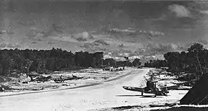 F4Us on Emirau | |
| Coordinates | 01°38.5′S 149°58.5′E |
| Type | Military Airfield |
| Site information | |
| Controlled by | United States Marine Corps Royal New Zealand Air Force |
| Site history | |
| Built | 1944 |
| Built by | Seebees |
| In use | 1944-present |
| Materials | Coral |
Emirau was seized unopposed by two Battalions of the 4th Marine Regiment on 20 March 1944.[2] Naval Construction Battalions arrived shortly after the landings and began construction of two coral-surfaced 7,000 feet (2,100 m) by 150 feet (46 m) airfields on the island. Inshore Airfield had 35 double hardstands capable of parking 210 fighter or light-bomber planes, while North Cape Airfield had 42 hardstands with space for parking 84 heavy bombers. Both were fully equipped with towers, lighting, and a dispensary. The aviation tank farm consisted of three 1,000 barrels (~140 t) tanks and nineteen 1,000 barrels (~140 t) together with the appropriate filling and distribution points. A reserve of 40,000 barrels (~5,500 t) was stored in drums.[2]:304 Emirau was the staging point for attacks on the Japanese strongholds at Rabaul and Kavieng.
US Marine Corps units based here included:
- VMSB-243 operating SBDs from June–December 1944
- VMB-413 operating PBJs[3]
- VMB-433 operating PBJs[4]
- VMB-443 operating PBJs[5]
- VMB-611 operating PBJs[6]
Royal New Zealand Air Force units based here included:[7]
- No. 1 Squadron operating PV-1s from May–June 1945
- No. 3 Squadron operating PV-1s
- No. 4 Squadron operating PV-1s from November 1944-February 1945 and June–July 1945
- No. 8 Squadron operating PV-1s from February–March 1945
- No. 9 Squadron operating PV-1s from March–May 1945
- No. 14 Squadron operating F4Us from July–August 1945
- No. 19 Squadron operating F4Us from November 1944-January 1945
- No. 22 Squadron operating F4Us from January–March 1945
- No. 23 Squadron from March–May 1945
- No. 25 Squadron operating F4Us from May–July 1945
There was also one Australian unit located on the island - the 474 Heavy Anti-aircraft Troop.
Base roll-up commenced in December 1944 and was completed by May 1945.[2]:304
Postwar
The runways remain usable.
References
- PNG Airstrip Guide. August 2005.
- Building the Navy's Bases in World War II History of the Bureau of Yards and Docks and the Civil Engineer Corps 1940-1946. US Government Printing Office. 1947. p. 303.
 This article incorporates text from this source, which is in the public domain.
 - http://www.vmb413.com/
- http://www.vmb433.com/
- http://www.vmb443.com/
- http://www.vmb611.com/
- "Royal New Zealand Air Force Operations from Emirau". Retrieved 12 June 2013.
