Emmetten
Emmetten is a municipality in the canton of Nidwalden in Switzerland.
Emmetten | |
|---|---|
 | |
 Coat of arms | |
Location of Emmetten 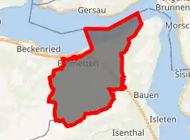
| |
 Emmetten Emmetten | |
| Coordinates: 46°57′N 8°31′E | |
| Country | Switzerland |
| Canton | Nidwalden |
| District | n.a. |
| Area | |
| • Total | 28.63 km2 (11.05 sq mi) |
| Elevation | 774 m (2,539 ft) |
| Population (2018-12-31)[2] | |
| • Total | 1,429 |
| • Density | 50/km2 (130/sq mi) |
| Time zone | UTC+01:00 (Central European Time) |
| • Summer (DST) | UTC+02:00 (Central European Summer Time) |
| Postal code(s) | 6376 |
| SFOS number | 1504 |
| Surrounded by | Beckenried, Gersau (SZ), Ingenbohl (SZ), Isenthal (UR), Seelisberg (UR) |
| Website | www SFSO statistics |
History
Emmetten is first mentioned about 1160 as Empnoten.[3]
Geography

Emmetten has an area, as of 2006, of 25 square kilometers (9.7 sq mi). Of this area, 37.9% is used for agricultural purposes, while 45.8% is forested. Of the rest of the land, 2.6% is settled (buildings or roads) and the remainder (13.7%) is non-productive (rivers, glaciers or mountains).[4]
The municipality is located along the cantonal highway between Beckenried and Seelisberg on both sides of the Egg crossing over the edge of Lake Lucerne.
Demographics
Emmetten has a population (as of 31 December 2019) of 1,440.[5] As of 2007, 15.4% of the population was made up of foreign nationals.[6] Over the last 10 years the population has grown at a rate of 3.7%. Most of the population (as of 2000) speaks German (91.8%), with English being second most common ( 1.8%) and Italian being third ( 1.5%).[4] As of 2008 the gender distribution of the population was 53.4% male and 46.6% female.
As of 2000 there are 487 households, of which 310 households (or about 63.7%) contain only one or two individuals. 36 or about 7.4% are large households, with at least five members.[7]
In the 2007 federal election the most popular party was the FDP which received 87.1% of the vote. Most of the rest of the votes went to local small right-wing parties (9.9%).[4]
In Emmetten about 69.1% of the population (between age 25-64) have completed either non-mandatory upper secondary education or additional higher education (either university or a Fachhochschule).[4]
The historical population is given in the following table:[3]
| year | population |
|---|---|
| 1743 | 378 |
| 1850 | 659 |
| 1860 | 603 |
| 1880 | 632 |
| 1900 | 593 |
| 1950 | 680 |
| 1960 | 698 |
| 1970 | 631 |
| 1980 | 715 |
| 1990 | 1,013 |
| 2000 | 1,222 |
| 2005 | 1,184 |
Industry
Emmetten has an unemployment rate of 0.94%. As of 2005, there were 75 people employed in the primary economic sector and about 27 businesses involved in this sector. 38 people are employed in the secondary sector and there are 9 businesses in this sector. 198 people are employed in the tertiary sector, with 42 businesses in this sector.[4]
Sights
The main sights of Emmetten are: the St. Anna chapel in Schöneck, the church St. Jakob und St. Theresia, the chapel of the holy cross with frescos of danse macabre in Sagendorf, and the chapel in Erlen.
References
- "Arealstatistik Standard - Gemeinden nach 4 Hauptbereichen". Federal Statistical Office. Retrieved 13 January 2019.
- "Ständige Wohnbevölkerung nach Staatsangehörigkeitskategorie Geschlecht und Gemeinde; Provisorische Jahresergebnisse; 2018". Federal Statistical Office. 9 April 2019. Retrieved 11 April 2019.
- Emmetten in German, French and Italian in the online Historical Dictionary of Switzerland.
- Swiss Federal Statistical Office Archived January 5, 2016, at the Wayback Machine accessed 04-Sep-2009
- "Ständige und nichtständige Wohnbevölkerung nach institutionellen Gliederungen, Geburtsort und Staatsangehörigkeit". bfs.admin.ch (in German). Swiss Federal Statistical Office - STAT-TAB. 31 December 2019. Retrieved 6 October 2020.
- Nidwalden Statistical Office-Population (in German) accessed 4 September 2009
- Nidwalden Statistical Office-Municipalities (in German) accessed 4 September 2009
| Wikimedia Commons has media related to Emmetten. |