Endenicher Bach
Endenicher Bach ("stream of Endenich") is a river of North Rhine-Westphalia, Germany.
| Endenicher Bach | |
|---|---|
 Flow from Endenicher Bach into Dransdorfer Bach | |
| Location | |
| Country | Germany |
| Location | Bonn, North Rhine-Westphalia |
| Reference no. | DE: 271982 |
| Physical characteristics | |
| Source | |
| • location | South of Röttgen (near the Jakobskreuz) |
| • coordinates | 50°40′03″N 7°04′09″E |
| • elevation | ca. 175 m above sea level (NHN) |
| Mouth | |
• location | In Endenich into the cities underground watersystem. |
• coordinates | 50°43′34″N 7°04′27″E |
• elevation | ca. 65 m above sea level (NHN) |
| Length | 11.565 km [1] |
| Basin size | 28.298 km² [1] |
| Basin features | |
| Progression | Dransdorfer Bach→ Rhine→ North Sea |
| Landmarks | Cities: Bonn |
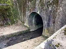 The underground part at Siemens Street | |
The Endenicher Bach is called Katzenlochbach at its origin but goes through some name changes on its way to a confluence with the Hardtbach (commonly known as the Dransdorfer Bach), which later flows into the river Rhine. It first changes into Endenicher Bach and later into Lengsdorfer Bach.[2] With a length of 11 kilometres (6.8 mi), it's the longest stream in Bonn.
References
This article is issued from Wikipedia. The text is licensed under Creative Commons - Attribution - Sharealike. Additional terms may apply for the media files.