English ship Mary (1650)
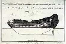
Speaker was a 50-gun third-rate frigate and the name ship of the Speaker-class, built for the navy of the Commonwealth of England by Christopher Pett at Woolwich Dockyard and launched in 1650.[1] At the Restoration she was renamed HMS Mary.[1] By 1677 her armament had been increased to 62 guns.[1]
%252C_by_Michael_Dahl.jpg.webp) Portrait of Rear-Admiral Basil Beaumont, commander of HMS Mary when she sunk, with the sinking Mary in the background | |
| History | |
|---|---|
| Name: | Speaker |
| Builder: | Christopher Pett, Woolwich Dockyard |
| Launched: | 1650 |
| Renamed: | HMS Mary, 1660 |
| Fate: | Wrecked, 1703 |
| General characteristics as built[1] | |
| Class and type: | Speaker-class frigate |
| Tons burthen: | 727 |
| Length: | 116 ft (35.4 m) (keel) |
| Beam: | 34 ft 8 in (10.6 m) |
| Depth of hold: | 14 ft 6 in (4.4 m) |
| Propulsion: | Sails |
| Sail plan: | Full-rigged ship |
| Armament: |
|
| General characteristics after 1688 rebuild[2] | |
| Class and type: | 62-gun third-rate ship of the line |
| Tons burthen: | 829 |
| Length: | 143 ft 3 in (43.7 m) (gundeck) |
| Beam: | 36 ft 8 in (11.2 m) |
| Depth of hold: | 14 ft 6 in (4.4 m) |
| Propulsion: | Sails |
| Sail plan: | Full-rigged ship |
| Armament: | 62 guns of various weights of shot |
In 1688 Mary was rebuilt by Thomas Shish at Woolwich Dockyard as a 62-gun third-rate ship of the line.[2] Mary was wrecked on the Goodwin Sands in the Great Storm of 1703.[2] Of her 275 crew, her captain and purser were ashore at the time of her loss; only one sailor survived.[3]
Wreck site
Local divers found the wreck site in 1980.[4] The initial designation was of 50 m around what is now known as the South Mound; the North Mound was discovered in 1999 and the area was amended under Statutory Instrument number 2004/2395 as a 300 m radius around 51° 15.6302' N, 01° 30.0262' E.[4]
It is believed that Mary lies under the South Mound and the North Mound is the third rate HMS Restoration wrecked in the same storm, but this is not known for certain.[4] The site lies 100 m to the west of the Goodwin Sands off Deal, between the wrecks of HMS Stirling Castle and HMS Northumberland, which also sank in the storm.[4]
The site was investigated by Wessex Archaeology on 25 June 2006.[4] The South Mound measures 28 m x 12 m but has not been studied in detail.[4]
Notes
- Lavery, Ships of the Line vol.1, p159.
- Lavery, Ships of the Line vol.1, p163.
- Larn, Richard (1977). Goodwin Sands Shipwrecks. Newton Abbot, London, North Pomfret: David & Charles. p. 56. ISBN 0 7153 7202 5.
- Wessex Archaeology (November 2006), RESTORATION, GOODWIN SANDS DESIGNATED SITE ASSESSMENT: ARCHAEOLOGICAL REPORT (PDF), English Heritage, retrieved 24 August 2009 Has many details of the history and the current state of the wreck site.
References
- Lavery, Brian (2003) The Ship of the Line - Volume 1: The development of the battlefleet 1650-1850. Conway Maritime Press. ISBN 0-85177-252-8.