Erbendorf
Erbendorf is a town in the Upper Palatinate (Oberpfalz) region of Germany. As of December, 2006, the town has a population of 5,341.
Erbendorf | |
|---|---|
 Coat of arms | |
Location of Erbendorf within Tirschenreuth district 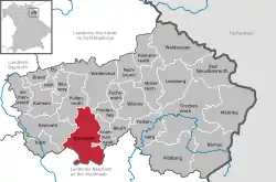 | |
 Erbendorf  Erbendorf | |
| Coordinates: 49°50′N 12°3′E | |
| Country | Germany |
| State | Bavaria |
| Admin. region | Oberpfalz |
| District | Tirschenreuth |
| Subdivisions | 23 Ortsteile |
| Government | |
| • Mayor | Hans Donko (CSU) |
| Area | |
| • Total | 67.55 km2 (26.08 sq mi) |
| Elevation | 506 m (1,660 ft) |
| Population (2019-12-31)[1] | |
| • Total | 5,033 |
| • Density | 75/km2 (190/sq mi) |
| Time zone | UTC+01:00 (CET) |
| • Summer (DST) | UTC+02:00 (CEST) |
| Postal codes | 92681 |
| Dialling codes | 09682 |
| Vehicle registration | TIR |
| Website | www.erbendorf.de |
The following villages are incorporated into the town: Aschenhof, Birkenreuth, Boxdorf, Eppenhof, Frodersreuth, Glashütte, Gössenreuth, Gramlhof, Grötschenreuth, Hauxdorf, Inglashof, Napfberg, Neuenreuth, Pfaben, Plärn, Schadenreuth, Siegritz, Steinbach, Straßenschacht, Thann, Wäldern, Wetzldorf, and Wildenreuth.
Main Attractions of Erbendorf
- Hiking and biking in the Stienwald region; a mountain range and a national park well known for its long-distance trails.
- The Mining Museum of Erbendorf, as the city has a very rich mining history.
- A public recreation center equipped with two heated outdoor pools.
- Walking tour of cellars.
Sons and daughters of the city
- Hans Müller (1898-1974), politician (SPD), Member of Bundestag 1953-1965
- Wilhelm Schraml (born 1935), 84. Bishop of Passau
Personalities who have worked in the city
- Norbert Scharf (1952-2010), Landtag deputy (SPD), was from 2005 to 2008 member of the town council of Erbendorf
References
- "Tabellenblatt "Daten 2", Statistischer Bericht A1200C 202041 Einwohnerzahlen der Gemeinden, Kreise und Regierungsbezirke". Bayerisches Landesamt für Statistik und Datenverarbeitung (in German). July 2020.
This article is issued from Wikipedia. The text is licensed under Creative Commons - Attribution - Sharealike. Additional terms may apply for the media files.
