Ergersheim, Middle Franconia
Ergersheim is a municipality in the Middle Franconian district of Neustadt (Aisch)-Bad Windsheim. Administrative offices are located in Uffenheim.
Ergersheim | |
|---|---|
 Coat of arms | |
Location of Ergersheim within Neustadt a.d.Aisch-Bad Windsheim district 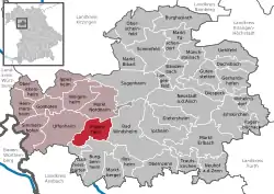 | |
 Ergersheim  Ergersheim | |
| Coordinates: 49°30.67′N 10°19.62′E | |
| Country | Germany |
| State | Bavaria |
| Admin. region | Mittelfranken |
| District | Neustadt a.d.Aisch-Bad Windsheim |
| Municipal assoc. | Uffenheim |
| Subdivisions | 6 Ortsteile |
| Government | |
| • Mayor | Gerhard Wunderlich |
| Area | |
| • Total | 30.04 km2 (11.60 sq mi) |
| Elevation | 334 m (1,096 ft) |
| Population (2019-12-31)[1] | |
| • Total | 1,043 |
| • Density | 35/km2 (90/sq mi) |
| Time zone | UTC+01:00 (CET) |
| • Summer (DST) | UTC+02:00 (CEST) |
| Postal codes | 91465 |
| Dialling codes | 09847 |
| Vehicle registration | NEA |
Villages
- Ergersheim
- Ermetzhofen
- Kellermühle
- Neuherberg
- Obermühle
- Seenheim
History
The first mention of Ergersheim was on December 25, 822 in a charter from the Emperor Louis the Pious.
Ergersheim is home to the oldest chapel of the area, built during that aera, and is still used for special church functions.
Politics
Town council
The town council is made up of 12 members. Election in 2014: (Comparison to 2008):
- Wählergemeinschaft Gemeinde Ermetzhofen 5 seats (± 0)
- Freie Wählergemeinschaft Ergersheim 7 seats (± 0)
Twin town
References
- "Tabellenblatt "Daten 2", Statistischer Bericht A1200C 202041 Einwohnerzahlen der Gemeinden, Kreise und Regierungsbezirke". Bayerisches Landesamt für Statistik und Datenverarbeitung (in German). July 2020.
External links
- Official website
 (in German)
Towns and municipalities in Neustadt (Aisch)-Bad Windsheim | ||
|---|---|---|
| Coat of Arms of Neustadt (Aisch)-Bad Windsheim district | |
This article is issued from Wikipedia. The text is licensed under Creative Commons - Attribution - Sharealike. Additional terms may apply for the media files.