Esperance (village), New York
Esperance is a village in Schoharie County, New York, United States. The population was 345 at the 2010 census. The village was given the French name for "hope."
Esperance, New York | |
|---|---|
 Esperance, New York Location within the state of New York | |
| Coordinates: 42°45′44″N 74°15′34″W | |
| Country | United States |
| State | New York |
| County | Schoharie |
| Area | |
| • Total | 0.52 sq mi (1.35 km2) |
| • Land | 0.49 sq mi (1.27 km2) |
| • Water | 0.03 sq mi (0.08 km2) |
| Elevation | 581 ft (177 m) |
| Population (2010) | |
| • Total | 345 |
| • Estimate (2019)[2] | 325 |
| • Density | 664.62/sq mi (256.43/km2) |
| Time zone | UTC-5 (Eastern (EST)) |
| • Summer (DST) | UTC-4 (EDT) |
| FIPS code | 36-24713 |
| GNIS feature ID | 0949711 |
| Website | www |
The Village of Esperance is in eastern part of the Town of Esperance. The village is west of Schenectady.
History
The village was settled around 1793, based on an original land grant the Ten Eyck Patent of 1769.
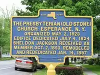
The village was incorporated in 1818 and a fire department was authorized to be formed. The village is the oldest incorporated village in the County. When the town of Esperance was formed in 1846, it took the name of the village.
Geography
Esperance is located at 42°45′44″N 74°15′33″W (42.762271, -74.259361).[3]
According to the United States Census Bureau, the village has a total area of 0.5 square miles (1.4 km2), of which, 0.5 square miles (1.3 km2) of it is land and 0.04 square miles (0.1 km2) of it (5.66%) is water.
The village is adjacent to the Schoharie Creek and is located on US Route 20 at the junction of County Roads 28 and 44.
Demographics
| Historical population | |||
|---|---|---|---|
| Census | Pop. | %± | |
| 1880 | 341 | — | |
| 1890 | 274 | −19.6% | |
| 1900 | 290 | 5.8% | |
| 1910 | 263 | −9.3% | |
| 1920 | 219 | −16.7% | |
| 1930 | 233 | 6.4% | |
| 1940 | 219 | −6.0% | |
| 1950 | 322 | 47.0% | |
| 1960 | 314 | −2.5% | |
| 1970 | 408 | 29.9% | |
| 1980 | 374 | −8.3% | |
| 1990 | 324 | −13.4% | |
| 2000 | 380 | 17.3% | |
| 2010 | 345 | −9.2% | |
| 2019 (est.) | 325 | [2] | −5.8% |
| U.S. Decennial Census[4] | |||
As of the census[5] of 2000, there were 380 people, 149 households, and 106 families residing in the village. The population density was 757.7 people per square mile (293.4/km2). There were 158 housing units at an average density of 315.1 per square mile (122.0/km2). The racial makeup of the village was 96.84% White, 1.58% Black or African American, 1.05% Asian, and 0.53% from two or more races. Hispanic or Latino of any race were 0.26% of the population.
There were 149 households, out of which 34.9% had children under the age of 18 living with them, 56.4% were married couples living together, 11.4% had a female householder with no husband present, and 28.2% were non-families. 21.5% of all households were made up of individuals, and 8.1% had someone living alone who was 65 years of age or older. The average household size was 2.55 and the average family size was 3.00.
In the village, the population was spread out, with 24.5% under the age of 18, 7.1% from 18 to 24, 30.3% from 25 to 44, 25.0% from 45 to 64, and 13.2% who were 65 years of age or older. The median age was 40 years. For every 100 females, there were 102.1 males. For every 100 females age 18 and over, there were 92.6 males.
The median income for a household in the village was $46,875, and the median income for a family was $49,375. Males had a median income of $37,000 versus $26,042 for females. The per capita income for the village was $17,985. About 3.7% of families and 3.9% of the population were below the poverty line, including 2.1% of those under age 18 and 7.4% of those age 65 or over.
Points of interest
- George Landis Arboretum, located north of the village.
References
- "2019 U.S. Gazetteer Files". United States Census Bureau. Retrieved July 27, 2020.
- "Population and Housing Unit Estimates". United States Census Bureau. May 24, 2020. Retrieved May 27, 2020.
- "US Gazetteer files: 2010, 2000, and 1990". United States Census Bureau. 2011-02-12. Retrieved 2011-04-23.
- "Census of Population and Housing". Census.gov. Retrieved June 4, 2015.
- "U.S. Census website". United States Census Bureau. Retrieved 2008-01-31.
External links
Municipalities and communities of Schoharie County, New York, United States | ||
|---|---|---|
| Villages | 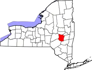 Map of New York highlighting Schoharie County | |
| Towns | ||
| CDPs | ||
| Hamlets | ||
| ||