Ettal
Ettal is a German municipality in the district of Garmisch-Partenkirchen, in Bavaria.
Ettal | |
|---|---|
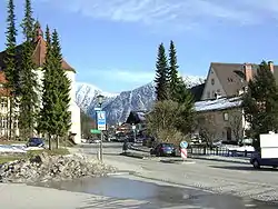 Ettal in March 2008 | |
 Coat of arms | |
Location of Ettal within Garmisch-Partenkirchen district 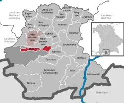 | |
 Ettal  Ettal | |
| Coordinates: 47°34′N 11°6′E | |
| Country | Germany |
| State | Bavaria |
| Admin. region | Oberbayern |
| District | Garmisch-Partenkirchen |
| Municipal assoc. | Unterammergau |
| Government | |
| • Mayor | Vanessa Voit (FW) |
| Area | |
| • Total | 140.75 km2 (54.34 sq mi) |
| Elevation | 877 m (2,877 ft) |
| Population (2019-12-31)[1] | |
| • Total | 758 |
| • Density | 5.4/km2 (14/sq mi) |
| Time zone | UTC+01:00 (CET) |
| • Summer (DST) | UTC+02:00 (CEST) |
| Postal codes | 82488 |
| Dialling codes | 08822 |
| Vehicle registration | GAP |
| Website | http://www.gemeinde-ettal.de/ |
Geography
Ettal is situated in the Oberland area in the Graswangtal between the Loisachtal and Ammertal, approx. 10 km north of Garmisch-Partenkirchen, the district capital, and approx. 4 km southwest of Oberammergau.
Division of the town
The town consists of 5 districts
- Ettal
- Graswang
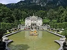
- Linderhof
- Dickelschwaig
- Rahm
See also
References
- "Tabellenblatt "Daten 2", Statistischer Bericht A1200C 202041 Einwohnerzahlen der Gemeinden, Kreise und Regierungsbezirke". Bayerisches Landesamt für Statistik und Datenverarbeitung (in German). July 2020.
External links
- Official site (in German)
Towns and municipalities in Garmisch-Partenkirchen (district) | ||
|---|---|---|
Coat of Arms of Garmisch-Partenkirchen district | ||
| Authority control |
|---|
This article is issued from Wikipedia. The text is licensed under Creative Commons - Attribution - Sharealike. Additional terms may apply for the media files.