Evenlode
Evenlode is a village and civil parish (ONS Code 23UC051) in the Cotswold District of eastern Gloucestershire in England.[2]
| Evenlode | |
|---|---|
 Evenlode Church | |
 Evenlode Location within Gloucestershire | |
| Population | 150 2016 est.[1] |
| OS grid reference | SP23003000 |
| Civil parish |
|
| District | |
| Shire county | |
| Region | |
| Country | England |
| Sovereign state | United Kingdom |
| Post town | Moreton-in-Marsh |
| Postcode district | GL56 |
| Police | Gloucestershire |
| Fire | Gloucestershire |
| Ambulance | South Western |
| Website | https://evenlodeparishcouncil.wordpress.com/ |
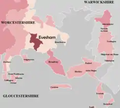
Evenlode is bordered by the Gloucestershire parishes of Moreton-in-Marsh to the northwest, Longborough and Donnington to the west, Broadwell to the southwest, and Adlestrop to the southeast;[3] and by the Oxfordshire parish of Chastleton to the east.[4]
At Evenlode's northern tip is the Four shire stone, whose name predates the parish's 1931 transfer from Worcestershire; here at a point between Moreton-in-Marsh and Chastleton are the Warwickshire parishes of Little Compton and Great Wolford,[5] as well as Batford in Gloucestershire.[3] At its southern tip, between Broadwell and Adlestrop, Evenlode meets the parish of Oddington at a point.[3]
History
The parish was granted before the 10th century to Worcester Priory, latterly as part of the manor of Blockley; the priory's scattered lands formed many of the detached parts of the County of Worcester. The Church of St Edward King & Martyr in Evenlode is a Grade II* Listed Building built in the 12th century and restored in 1879.[6] It is a Church of England parish church in the Diocese of Gloucester, with an average attendance of 20 at Sunday service in 2015.[7]
Until 1931 it was a detached part of Worcestershire, in the hundred of Oswaldslow, southeast of the main body of the county.[8] The River Evenlode, which shares its name, forms the parish's western boundary.
References
- Oxford Consultants for Social Inclusion (9 November 2016). "Local Insight profile for 'Evenlode CP' area". Gloucestershire Parish Profiles. Gloucestershire County Council. p. 4. Retrieved 2 May 2018.
- "Parishes: Evenlode". Victoria County History: Worcester. 3. London: British History Online. pp. 347–352. Retrieved 2 May 2018.
- "Gloucestershire". Ordnance Survey Miscellaneous Boundary Maps. Vision of Britain. 1967. Retrieved 3 May 2018.
- "Oxfordshire". Ordnance Survey Miscellaneous Boundary Maps. Vision of Britain. 1966. Retrieved 3 May 2018.
- "Warwickshire". Ordnance Survey Maps of England and Wales. Vision of Britain. 1900. Retrieved 3 May 2018.
- "Church of St Edward, Evenlode, Gloucestershire". britishlistedbuildings.co.uk. Retrieved 2 May 2018.
- Church of England Research and Statistics (March 2017). "Dashboard for the parish of Evenlode: St Edward King & Martyr in the Deanery of North Cotswold" (PDF). Diocese of Gloucester. Retrieved 2 May 2018.
- Provisional Order Confirmation (Gloucestershire, Warwickshire and Worcestershire) Act 1931
External links
- Evenlode Parish Council website
- Evenlode citypopulation.de