Fairfield Bay, Arkansas
Fairfield Bay is a city in Cleburne and Van Buren counties in the northern part of the U.S. state of Arkansas. The population was 2,338 at the 2010 census.[3] The population in its portion in Van Buren County, which accounts for the bulk of the city limits, made the city the most populous in Van Buren County as of the 2000 census, but with a slight decline in population, lost the distinction to Clinton as of 2010.
Fairfield Bay, Arkansas | |
|---|---|
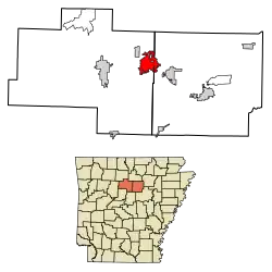 Location of Fairfield Bay in Cleburne County and Van Buren County, Arkansas. | |
| Coordinates: 35°36′7″N 92°15′51″W | |
| Country | United States |
| State | Arkansas |
| Counties | Van Buren, Cleburne |
| Area | |
| • Total | 15.19 sq mi (39.34 km2) |
| • Land | 15.13 sq mi (39.19 km2) |
| • Water | 0.06 sq mi (0.16 km2) |
| Elevation | 869 ft (265 m) |
| Population (2010) | |
| • Total | 2,338 |
| • Estimate (2019)[2] | 2,189 |
| • Density | 144.68/sq mi (55.86/km2) |
| Time zone | UTC-6 (Central (CST)) |
| • Summer (DST) | UTC-5 (CDT) |
| ZIP code | 72088 |
| Area code(s) | 501 |
| FIPS code | 05-22660 |
| GNIS feature ID | 0057738 |
| Website | www |
Fairfield Bay, located on the shore of Greers Ferry Lake, is home to Fairfield Bay Resort, the namesake of Wyndham Worldwide-owned Fairfield Resorts.
Geography
Fairfield Bay is located in eastern Van Buren County at 35°36′07″N 92°15′51″W,[4] extending eastward into Cleburne County. It is located on hills overlooking the northern shore of Greers Ferry Lake, a reservoir on the Little Red River, a tributary of the White River which flows to the Mississippi.
According to the United States Census Bureau, the city has a total area of 15.3 square miles (39.7 km2), of which 15.3 square miles (39.5 km2) is land and 0.04 square miles (0.1 km2), or 0.36%, is water.[3]
Demographics
| Historical population | |||
|---|---|---|---|
| Census | Pop. | %± | |
| 2000 | 2,460 | — | |
| 2010 | 2,338 | −5.0% | |
| 2019 (est.) | 2,189 | [2] | −6.4% |
| U.S. Decennial Census[5] 2014 Estimate[6] | |||
As of the census[7] of 2000, there were 2,460 people, 1,231 households, and 833 families residing in the city. The population density was 162.1 people per square mile (62.6/km2). There were 1,976 housing units at an average density of 130.2 per square mile (50.3/km2). The racial makeup of the city was 98.41% White, 0.53% Black or African American, 0.16% Native American, 0.24% Asian, and 0.65% from two or more races. 0.53% of the population were Hispanic or Latino of any race.
There were 1,231 households, out of which 8.9% had children under the age of 18 living with them, 62.0% were married couples living together, 4.3% had a female householder with no husband present, and 32.3% were non-families. 29.7% of all households were made up of individuals, and 21.9% had someone living alone who was 65 years of age or older. The average household size was 1.91 and the average family size was 2.29.
In the city, the population was spread out, with 9.3% under the age of 18, 2.6% from 18 to 24, 10.2% from 25 to 44, 25.3% from 45 to 64, and 52.6% who were 65 years of age or older. The median age was 66 years. For every 100 females, there were 82.4 males. For every 100 females age 18 and over, there were 82.0 males.
The median income for a household in the city was $35,089, and the median income for a family was $42,419. Males had a median income of $30,337 versus $21,625 for females. The per capita income for the city was $24,900. About 4.8% of families and 7.1% of the population were below the poverty line, including 20.1% of those under age 18 and 3.4% of those age 65 or over.
Education
Public education for elementary and secondary students is provided by the Shirley School District in Van Buren County and by the West Side School District for Cleburne County.
References
- "2019 U.S. Gazetteer Files". United States Census Bureau. Retrieved June 30, 2020.
- "Population and Housing Unit Estimates". United States Census Bureau. May 24, 2020. Retrieved May 27, 2020.
- "Geographic Identifiers: 2010 Demographic Profile Data (G001): Fairfield Bay city, Arkansas". U.S. Census Bureau, American Factfinder. Archived from the original on February 12, 2020. Retrieved June 17, 2014.
- "US Gazetteer files: 2010, 2000, and 1990". United States Census Bureau. 2011-02-12. Retrieved 2011-04-23.
- "Census of Population and Housing". Census.gov. Retrieved June 4, 2015.
- "Annual Estimates of the Resident Population for Incorporated Places: April 1, 2010 to July 1, 2014". Archived from the original on May 22, 2015. Retrieved June 4, 2015.
- "U.S. Census website". United States Census Bureau. Retrieved 2008-01-31.
External links
Municipalities and communities of Cleburne County, Arkansas, United States | ||
|---|---|---|
| Cities | 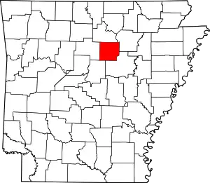 Map of Arkansas highlighting Cleburne County | |
| Towns | ||
| CDP | ||
| Unincorporated communities | ||
| Footnotes | ‡This populated place also has portions in an adjacent county or counties | |
| ||
Municipalities and communities of Van Buren County, Arkansas, United States | ||
|---|---|---|
| Cities | 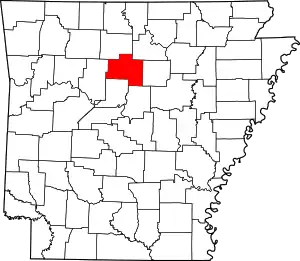 Map of Arkansas highlighting Van Buren County | |
| Towns | ||
| CDP | ||
| Townships |
| |
| Unincorporated communities | ||
| Ghost town | ||
| Footnotes | ‡This populated place also has portions in an adjacent county or counties | |
| ||