Fara, Kostel
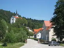
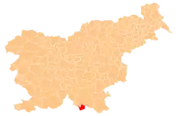
Fara (pronounced [ˈfaːɾa]) is a settlement on the left bank of the Kolpa River in the Municipality of Kostel in southern Slovenia. The municipal administration is based in the settlement. The area is part of the traditional region of Lower Carniola and is now included in the Southeast Slovenia Statistical Region.[2]
Fara | |
|---|---|
 | |
 Fara Location in Slovenia | |
| Coordinates: 45°28′37.4″N 14°52′56.75″E | |
| Country | Slovenia |
| Traditional region | Lower Carniola |
| Statistical region | Southeast Slovenia |
| Municipality | Kostel |
| Area | |
| • Total | 1.37 km2 (0.53 sq mi) |
| Elevation | 227.9 m (747.7 ft) |
| Population (2002) | |
| • Total | 29 |
| [1] | |
The local parish church is dedicated to the Assumption of Mary and belongs to the Roman Catholic Diocese of Novo Mesto. It is a large building with a triple nave that was built between 1858 and 1864 in the Neo-Romanesque style on the site of an earlier church.[3] A second church in the village is dedicated to Saint Stephen and is a late 16th- or early 17th-century building that was refurbished in the 18th and 19th centuries.[4]
References
- Statistical Office of the Republic of Slovenia
- Kostel municipal site
- Slovenian Ministry of Culture register of national heritage reference number ešd 1806
- Slovenian Ministry of Culture register of national heritage reference number ešd 1807
External links
 Media related to Fara, Kostel at Wikimedia Commons
- Fara on Geopedia
| Settlements | Administrative centre: Vas
|  | ||||
|---|---|---|---|---|---|---|
| Landmarks | ||||||
This article is issued from Wikipedia. The text is licensed under Creative Commons - Attribution - Sharealike. Additional terms may apply for the media files.