Farm to Market Road 585
Farm to Market Road 585 (FM 585) is a farm to market road located in Brown and Coleman counties in west central Texas.[1]
| ||||
|---|---|---|---|---|
| ||||
| Route information | ||||
| Maintained by TxDOT | ||||
| Length | 22.583 mi[1] (36.344 km) | |||
| Existed | July 16, 1945–present | |||
| Major junctions | ||||
| South end | ||||
| North end | ||||
| Location | ||||
| Counties | Brown, Coleman | |||
| Highway system | ||||
| ||||

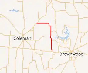
Route description
FM 585 begins at an intersection with US 67 / US 84 approximately 1.7 miles (2.7 km) west of Bangs.[2] The roadway travels to the north through unincorporated Brown County, intersecting FM 2492 west of Thrifty and FM 1850 west of Grosvenor.[3] FM 585 then curves to the west and enters Coleman County before reaching its terminus at SH 206 near the community of Echo between Coleman and Burkett.[1]
History
FM 585 was designated on July 16, 1945. The highway originally ran from its junction with US 84 northward approximately 6.5 miles (10.5 km) to the road connecting the communities of Thrifty and Fry (present-day FM 2492). On October 26, 1954, the roadway was extended north to the intersection with FM 1850. The route reached its current length on May 2, 1962, when it was extended northward and westward to connect with SH 206, replacing FM 2560.[1]
Major intersections
| County | Location | mi[4] | km | Destinations | Notes |
|---|---|---|---|---|---|
| Brown | | 0.0 | 0.0 | Southern terminus | |
| | 6.2 | 10.0 | |||
| | 11.0 | 17.7 | |||
| Coleman | | 22.6 | 36.4 | Northern terminus | |
| 1.000 mi = 1.609 km; 1.000 km = 0.621 mi | |||||
References
- Transportation Planning and Programming Division (n.d.). "Farm to Market Road No. 585". Highway Designation Files. Texas Department of Transportation. Retrieved October 28, 2012.
- Transportation Planning and Programming Division (2012). Texas County Mapbook (PDF) (Map) (2012 ed.). 1:120,000. Texas Department of Transportation. p. 337. OCLC 867856197. Retrieved October 28, 2012.
- Transportation Planning and Programming Division (2012). Texas County Mapbook (PDF) (Map) (2012 ed.). 1:120,000. Texas Department of Transportation. p. 336. OCLC 867856197. Retrieved October 28, 2012.
- Google (October 28, 2012). "FM 585 Overview Map with Major Intersections" (Map). Google Maps. Google. Retrieved October 28, 2012.