Farm to Market Road 865
Farm to Market Road 865 (FM 865) is a state highway within the Houston–Sugar Land–Baytown metropolitan area in the U.S. state of Texas. Locally, the road is known as Cullen Boulevard.
| ||||
|---|---|---|---|---|

| ||||
| Route information | ||||
| Length | 10.117 mi[1] (16.282 km) | |||
| Existed | September 13, 1984[1]–present | |||
| Major junctions | ||||
| South end | ||||
| North end | ||||
| Highway system | ||||
| ||||
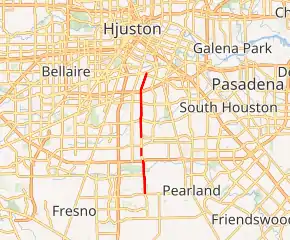
FM 865 runs 10.117 miles (16.282 km) between FM 518 in Pearland and U.S. Highway 90A (US 90A) in south Houston, mostly as a four-lane divided arterial.[2]
Originally established in 1984, the current routing of FM 865 is the third iteration of that designation. Earlier routings are now part of US 190 and State Highway 137 (SH 137).[1] Internally, FM 865 is designated as Urban Road 865 (UR 865) by TxDOT,[3] but the route continues to be signed as a farm-to-market road.
Route description
FM 865 begins at FM 518 in Pearland. It continues into Harris County, straddling the Houston city limits as it intersects the Sam Houston Tollway and Beltway 8. The route then runs through southern Houston before intersecting Interstate 610. FM 865 then crosses railroad tracks before ending at US 90A. Cullen Boulevard continues as a city street from here to Brays Bayou.[2]
History
First designation
The first iteration of FM 865 was established on October 29, 1948 for a route in Schleicher County. This route ran from US 277 west for approximately 8.0 miles (12.9 km). This designation was canceled on July 14, 1949 and merged with Ranch to Market Road 33 (RM 33),[1] and the alignment became part of US 190 on June 30, 1977.[4]
Second designation
The second FM 865 was designated on May 23, 1951 as a route in Crockett County. This alignment went from SH 163 in Ozona to an oil field about 9.0 miles (14.5 km) west of town. The road was extended to RM 33 on November 20 of that year. On November 13, 1959, the road was reclassified as a ranch-to-market road. RM 865 was deleted on May 16, 1984 and combined with SH 137.
Current designation
The third designation of FM 865 was established on September 13, 1984 along the current alignment; the mileage was transferred from FM 518 as part of a realignment of the latter onto the routing of the canceled FM 3344.[5][6] On June 27, 1995, the route was re-designated as an urban road. However, the route is still signed as a farm-to-market road.[1][3]
Major intersections
| County | Location | mi | km | Destinations | Notes |
|---|---|---|---|---|---|
| Brazoria | Pearland | 0.0 | 0.0 | ||
| Harris | Houston | 2.0 | 3.2 | ||
| 8.0 | 12.9 | I-610 exit 36A westbound, 36B eastbound | |||
| 1.000 mi = 1.609 km; 1.000 km = 0.621 mi | |||||
References
- Transportation Planning and Programming Division (n.d.). "Farm to Market Road No. 865". Highway Designation Files. Texas Department of Transportation. Retrieved May 27, 2018.
- Google (May 27, 2018). "Map of Farm to Market Road 865" (Map). Google Maps. Google. Retrieved May 27, 2018.
- Transportation Planning and Programming Division (n.d.). "Urban Road No. 865". Highway Designation Files. Texas Department of Transportation. Retrieved May 27, 2018.
- Transportation Planning and Programming Division (n.d.). "Ranch to Market Road No. 33". Highway Designation Files. Texas Department of Transportation. Retrieved May 27, 2018.
- Transportation Planning and Programming Division (n.d.). "Farm to Market Road No. 518". Highway Designation Files. Texas Department of Transportation. Retrieved May 27, 2018.
- Transportation Planning and Programming Division (n.d.). "Farm to Market Road No. 3344". Highway Designation Files. Texas Department of Transportation. Retrieved May 27, 2018.
