Fasli, Cyprus
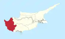
Fasli (Greek: Φάσλι) is an abandoned Turkish Cypriot village in the Paphos District of Cyprus, located 2 km south of Androlikou.[2][3]
Fasli
Φάσλι | |
|---|---|
 Fasli Location in Cyprus | |
| Coordinates: 34.9817°N 32.3706°E | |
| Country | |
| District | Paphos District |
| Elevation | 515 m (1,690 ft) |
| Population (2001)[1] | |
| • Total | 0 |
| Time zone | UTC+2 (EET) |
| • Summer (DST) | UTC+3 (EEST) |
| Postal code | 6354 |
Naming
Fasli is a village located near the Akamas peninsula, nine kilometers southwest of Polis and four kilometers northwest of Dhrousha. It is believed by many that the name Phasli or Fasli derives from fasla, meaning “plot of land.” The villagers of Androlikou and Fasli believe that after a land dispute in Androlikou, the agha of the village told one of the opponents that he was willing to give him one fasla if he agreed to move where the current village is situated. He apparently accepted the offer, and the village was founded and called Fasla. The Turkish Cypriots eventually slightly changed the name from Fasla to Faslı.[4]
Misspelling
Fasli is often misspelled as Phasli.[7]
References
- Census 2001
- "Cyprus alive". Cyprus alive.
- "Fasli". www.hellenicaworld.com. Retrieved 2019-07-17.
- "FASLI". www.prio-cyprus-displacement.net. Retrieved 2019-07-17.
- "GeoNames.org". www.geonames.org. Retrieved 2019-07-17.
- "Forecast for Fásli". yr.no. Retrieved 2019-07-17.
- "Fasli Map, Weather and Photos - Cyprus: abandoned populated place - Lat:34.9833 and Long:32.3708". www.getamap.net. Retrieved 2019-07-17.