Feni, Bangladesh
Feni (Bengali: ফেনী) is a city in the Chittagong Division of south-eastern Bangladesh.[3] It is the headquarters of Feni Sadar Upazila and Feni District. The city has a population of about 2,65,000, making it the 18th largest city in Bangladesh. Feni is the oldest municipality in this region, established in 1958.[1]
Feni
ফেনী Shamshernagar শমসেরনগর | |
|---|---|
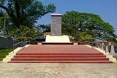 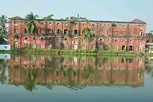 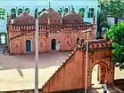 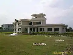 clockwise: Monument of freedom fighter in Feni city, Administrative Building of Feni Government College, Mohammad Ali Chowdhury mosque, Feni Girls' Cadet College | |
 Feni Location in Bangladesh | |
| Coordinates: 23°1.1′N 91°24.6′E | |
| Country | |
| Division | Chittagong Division |
| District | Feni District |
| City | 1881,1929 |
| Municipality | 1958 |
| Administrative District City | 1984 |
| Government | |
| • Type | Mayor–Council |
| • Body | Feni Municipality |
| • Paura Mayor | Nazrul Islam Shwapon Miaji |
| Area | |
| • Total | 22.0 km2 (8.5 sq mi) |
| Population | |
| • Total | 265,000 |
| • Density | 12,000/km2 (31,000/sq mi) |
| • Rank | 18th |
| Time zone | UTC+6 (Bangladesh Time) |
| Postal code | 3900[2] |
| National Dialing Code | +880 |
| Local Dialing Code | +88-0331 |
History
Feni city came into existence in 1929. It learnt that, in the long past this area was under marshy land and meaning Feni. The continuous silting process made it possible for human habitation to be established, as a result of which people far and near called this area Feni. [4]
Administration
Feni city consists of a paurashava with 18 wards and 35 mahallas. The entire city is under paurashava.[4]
Geography
Feni is located at 23.0186°N 91.3966°E in the southeastern region of Bangladesh.
Demographics
In 2020, Feni city's current population is about 270000 according to record of feni municipality .
Education
The literacy rate (7 years and above 7 years) in Feni City is 81.7%.
References
- Bhuiyan, Md Abu Taher (2012). "Feni Sadar Upazila". In Islam, Sirajul; Jamal, Ahmed A. (eds.). Banglapedia: National Encyclopedia of Bangladesh (Second ed.). Asiatic Society of Bangladesh.
- Staff. "ZIP Code database of Bangladesh". Geopostcodes.com. Retrieved 11 June 2008.
- "NGA GeoNames Database". National Geospatial-Intelligence Agency. Retrieved 2 January 2015.
- "Population & Housing Census-2011" (PDF). Bangladesh Bureau of Statistics. Retrieved 2019-10-05.