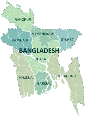
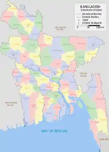
Districts of Bangladesh
The divisions of Bangladesh are divided into 64[1] districts or zila. The capital of a district is called a district seat (zila sadar). The districts are further subdivided into 493 sub-districts or upazila.
 |
|---|
| This article is part of a series on the politics and government of Bangladesh |
|
|

History
Before independence, Bangladesh (then known as East Pakistan) had 20 districts.
Administration
Deputy commissioner
A deputy commissioner (popularly abbreviated to "DC") is the executive head of the district. Deputy commissioners are appointed by the government from the deputy secretary BCS Administration Cadre.
District councils
A district council (or zila parishad) is a local government body at the district level.[2] The Bengali word parishad means council and zila parishad translates to district council.
The functions of a district council include construction and maintenance of roads, and bridges, building hospitals and dispensaries, schools and educational institutions, health facilities and sanitation, tube wells for drinking water, rest houses, and coordination of activities of the Union parishads within the district.
Timeline of creation
- 1666
- Chittagong district.[3]
- 1772
- Rangpur district.[4]
- 1772
- Dhaka district.
- Jashore district.[5]
- 3 January 1782
- Sylhet district.[6]
- 1786
- Dinajpur district.[7]
- 1787
- Mymensingh district.[8]
- 1790
- Comilla district.[9]
- 1797
- Barisal district.[10]
- 1815
- Faridpur district.[11]
- 1821
- 1832
- Pabna district.[14]
- 1860
- Hill Tracts district is split from Chittagong district.[3]
- 1882
- Khulna district.[15]
- 1947
- Kushtia district.[16]
- 1969
- 1971
- Dhaka Division: Dhaka district, Faridpur district, Mymensingh district, Tangail district
- Chittagong Division: Hill Tracts district, Chittagong district, Comilla district, Noakhali district, Sylhet district, Cox's Bazar district
- Rajshahi Division: Bogura district, Dinajpur district, Rajshahi district, Rangpur district, Pabna district
- Khulna Division: Bakerganj district, Jashore district, Khulna district, Kushtia district, Patuakhali district
- 1978
- Jamalpur district is split from Mymensingh district.[8]
- 1983
- Joypurhat district was split from Bogra district.[13]
- 1 February 1984
- Rangpur district.[18]
- 22 February 1984
- Brahmanbaria district was split from Comilla district.
- Sirajganj district was split from Pabna district.
- Sherpur, Netrokona and Kishoreganj districts were split from Mymensingh district.[8]
- Lakshmipur and Feni districts were split from Noakhali district.
- Sunamganj, Habiganj and Maulvibazar districts were split from Sylhet district.[6]
- Thakurgaon and Panchagarh districts were split from Dinajpur district.[7]
- 1 March 1984
- Cox’s Bazar district.[19]
District List
| District | Bengali | Division | Established | Population (thousands)[20] | Area (km2)[20] |
|---|---|---|---|---|---|
| Barguna District | বরগুনা | Barisal | 1984 | 892 | 1939 |
| Barisal District | বরিশাল | Barisal | 1797 | 2415 | 2785 |
| Bhola District | ভোলা | Barisal | 1984 | 1946 | 3403 |
| Jhalokati District | ঝালকাঠি | Barisal | 1984 | 710 | 749 |
| Patuakhali District | পটুয়াখালি | Barisal | 1969 | 1596 | 3221 |
| Pirojpur District | পিরোজপুর | Barisal | 1984 | 1277 | 1308 |
| Bandarban District | বান্দরবান | Chittagong | 1981 | 405 | 4479 |
| Brahmanbaria District | ব্রাহ্মণবাড়িয়া | Chittagong | 1984 | 2954 | 1927 |
| Chandpur District | চাঁদপুর | Chittagong | 1984 | 2514 | 1704 |
| Chittagong District | চট্টগ্রাম | Chittagong | 1666 | 7913 | 5283 |
| Comilla District | কুমিল্লা | Chittagong | 1790 | 6003 | 3085 |
| Cox's Bazar District | কক্সবাজার | Chittagong | 1984 | 2382 | 2492 |
| Feni District | ফেনী | Chittagong | 1984 | 1496 | 928 |
| Khagrachhari District | খাগড়াছড়ি | Chittagong | 1983 | 639 | 2700 |
| Lakshmipur District | লক্ষ্মীপুর | Chittagong | 1984 | 1798 | 1456 |
| Noakhali District | নোয়াখালি | Chittagong | 1821 | 3232 | 3601 |
| Rangamati District | রাঙ্গামাটি | Chittagong | 1983 | 620 | 6116 |
| Dhaka District | ঢাকা | Dhaka | 1772 | 12518 | 1464 |
| Faridpur District | ফরিদপুর | Dhaka | 1815 | 1989 | 2073 |
| Gazipur District | গাজীপুর | Dhaka | 1984 | 3548 | 1800 |
| Gopalganj District | গোপালগঞ্জ | Dhaka | 1984 | 1218 | 1490 |
| Kishoreganj District | কিশোরগঞ্জ | Dhaka | 1984 | 3029 | 2689 |
| Madaripur District | মাদারিপুর | Dhaka | 1984 | 1212 | 1145 |
| Manikganj District | মানিকগঞ্জ | Dhaka | 1984 | 1447 | 1379 |
| Munshiganj District | মুন্সিগঞ্জ | Dhaka | 1984 | 1503 | 955 |
| Narayanganj District | নারায়ণগঞ্জ | Dhaka | 1984 | 3074 | 700 |
| Narsingdi District | নরসিংদি | Dhaka | 1984 | 2315 | 1141 |
| Rajbari District | রাজবাড়ি | Dhaka | 1984 | 1091 | 1119 |
| Shariatpur District | শরিয়তপুর | Dhaka | 1984 | 1202 | 1182 |
| Tangail District | টাঙ্গাইল | Dhaka | 1969 | 3750 | 3414 |
| Bagerhat District | বাগেরহাট | Khulna | 1984 | 1461 | 3959 |
| Chuadanga District | চুয়াডাঙ্গা | Khulna | 1984 | 1123 | 1177 |
| Jessore District | যশোর | Khulna | 1781 | 2742 | 2567 |
| Jhenaidah District | ঝিনাইদহ | Khulna | 1984 | 1756 | 1961 |
| Khulna District | খুলনা | Khulna | 1882 | 2294 | 4394 |
| Kushtia District | কুষ্টিয়া | Khulna | 1947 | 1933 | 1601 |
| Magura District | মাগুরা | Khulna | 1984 | 913 | 1049 |
| Meherpur District | মেহেরপুর | Khulna | 1984 | 652 | 716 |
| Narail District | নড়াইল | Khulna | 1984 | 715 | 990 |
| Satkhira District | সাতক্ষীরা | Khulna | 1984 | 1973 | 3858 |
| Jamalpur District | জামালপুর | Mymensingh | 1978 | 2265 | 2032 |
| Mymensingh District | ময়মনসিংহ | Mymensingh | 1787 | 5042 | 4363 |
| Netrokona District | নেত্রকোনা | Mymensingh | 1984 | 2207 | 2810 |
| Sherpur District | শেরপুর | Mymensingh | 1984 | 1334 | 1364 |
| Bogra District | বগুড়া | Rajshahi | 1821 | 3370 | 2920 |
| Joypurhat District | জয়পুরহাট | Rajshahi | 1983 | 909 | 965 |
| Naogaon District | নওগাঁ | Rajshahi | 1984 | 2576 | 3436 |
| Natore District | নাটোর | Rajshahi | 1984 | 1696 | 1896 |
| Chapainawabganj District | চাঁপাইনবাবগঞ্জ | Rajshahi | 1984 | 1647 | 1703 |
| Pabna District | পাবনা | Rajshahi | 1832 | 2497 | 2372 |
| Rajshahi District | রাজশাহী | Rajshahi | 1772 | 2573 | 2407 |
| Sirajganj District | সিরাজগঞ্জ | Rajshahi | 1984 | 3072 | 2498 |
| Dinajpur District | দিনাজপুর | Rangpur | 1786 | 2980 | 3438 |
| Gaibandha District | গাইবান্ধা | Rangpur | 1984 | 2349 | 2179 |
| Kurigram District | কুড়িগ্রাম | Rangpur | 1984 | 2050 | 2296 |
| Lalmonirhat District | লালমনিরহাট | Rangpur | 1984 | 1249 | 1241 |
| Nilphamari District | নীলফামারী | Rangpur | 1984 | 1820 | 1580 |
| Panchagarh District | পঞ্চগড় | Rangpur | 1984 | 981 | 1405 |
| Rangpur District | রংপুর | Rangpur | 1772 | 2866 | 2368 |
| Thakurgaon District | ঠাকুরগাঁও | Rangpur | 1984 | 1380 | 1810 |
| Habiganj District | হবিগঞ্জ | Sylhet | 1984 | 2059 | 2637 |
| Moulvibazar District | মৌলভীবাজার | Sylhet | 1984 | 1902 | 2799 |
| Sunamganj District | সুনামগঞ্জ | Sylhet | 1984 | 2443 | 3670 |
| Sylhet District | সিলেট | Sylhet | 1782 | 5316 | 3490 |
English spelling change
In April 2018, the government changed the English spelling of five districts to avoid inconsistencies in the Bengali and English spellings. The spellings have been changed from Bogra to Bogura, Barisal to Barishal, Jessore to Jashore, Chittagong to Chattogram and Comilla to Cumilla.[21][22]
References
- বাংলাদেশ জাতীয় তথ্য বাতায়ন - গণপ্রজাতন্ত্রী বাংলাদেশ সরকার. bangladesh.gov.bd.
- Kamal Siddiqui. "Local Government". In Sirajul Islam (ed.). Banglapedia: National Encyclopedia of Bangladesh. Asiatic Society of Bangladesh.
- Harun, Jasim (2012). "Chittagong District". In Islam, Sirajul; Jamal, Ahmed A. (eds.). Banglapedia: National Encyclopedia of Bangladesh (Second ed.). Asiatic Society of Bangladesh.
- Rahman, Md. (2012). "Rangpur District". In Islam, Sirajul; Jamal, Ahmed A. (eds.). Banglapedia: National Encyclopedia of Bangladesh (Second ed.). Asiatic Society of Bangladesh.
- Siddiqui, Mahibullah (2012). "Jashore District". In Islam, Sirajul; Jamal, Ahmed A. (eds.). Banglapedia: National Encyclopedia of Bangladesh (Second ed.). Asiatic Society of Bangladesh.
- Hossain, Ashfaq (2012). "Sylhet District". In Islam, Sirajul; Jamal, Ahmed A. (eds.). Banglapedia: National Encyclopedia of Bangladesh (Second ed.). Asiatic Society of Bangladesh.
- Hossain, Ashfaq (2012). "Dinajpur District". In Islam, Sirajul; Jamal, Ahmed A. (eds.). Banglapedia: National Encyclopedia of Bangladesh (Second ed.). Asiatic Society of Bangladesh.
- ময়মনসিংহ জেলা. Mymensingh District. Retrieved 19 July 2019.
- Siddiqi, Mamun (2012). "Comilla District". In Islam, Sirajul; Jamal, Ahmed A. (eds.). Banglapedia: National Encyclopedia of Bangladesh (Second ed.). Asiatic Society of Bangladesh.
- Islam, KAM (2012). "Barisal District". In Islam, Sirajul; Jamal, Ahmed A. (eds.). Banglapedia: National Encyclopedia of Bangladesh (Second ed.). Asiatic Society of Bangladesh.
- Reza, Masud (2012). "Faridpur District". In Islam, Sirajul; Jamal, Ahmed A. (eds.). Banglapedia: National Encyclopedia of Bangladesh (Second ed.). Asiatic Society of Bangladesh.
- Lipi, Jahanara (2012). "Noakhali District". In Islam, Sirajul; Jamal, Ahmed A. (eds.). Banglapedia: National Encyclopedia of Bangladesh (Second ed.). Asiatic Society of Bangladesh.
- Haq, Md (2012). "Bogra District". In Islam, Sirajul; Jamal, Ahmed A. (eds.). Banglapedia: National Encyclopedia of Bangladesh (Second ed.). Asiatic Society of Bangladesh.
- Alam, Md (2012). "Pabna District". In Islam, Sirajul; Jamal, Ahmed A. (eds.). Banglapedia: National Encyclopedia of Bangladesh (Second ed.). Asiatic Society of Bangladesh.
- Mallik, Sandipak (2012). "Khulna District". In Islam, Sirajul; Jamal, Ahmed A. (eds.). Banglapedia: National Encyclopedia of Bangladesh (Second ed.). Asiatic Society of Bangladesh.
- Nehal, SM (2012). "Kushtia District". In Islam, Sirajul; Jamal, Ahmed A. (eds.). Banglapedia: National Encyclopedia of Bangladesh (Second ed.). Asiatic Society of Bangladesh.
- Jerin, Iffat (2012). "Patuakhali District". In Islam, Sirajul; Jamal, Ahmed A. (eds.). Banglapedia: National Encyclopedia of Bangladesh (Second ed.). Asiatic Society of Bangladesh.
- Sattar, Abdus (2012). "Rangpur District". In Islam, Sirajul; Jamal, Ahmed A. (eds.). Banglapedia: National Encyclopedia of Bangladesh (Second ed.). Asiatic Society of Bangladesh.
- Siddiqi, Mohammad (2012). "Cox's_Bazar District". In Islam, Sirajul; Jamal, Ahmed A. (eds.). Banglapedia: National Encyclopedia of Bangladesh (Second ed.). Asiatic Society of Bangladesh.
- "2011 Population & Housing Census: Preliminary Results" (PDF). Bangladesh Bureau of Statistics. Archived from the original (PDF) on 15 January 2013. Retrieved 12 January 2012.
- "English spelling of five districts changed". The Independent. 3 April 2018. Retrieved 20 November 2018.
- "Bangladesh changes English spellings of five districts". BD News 24. 2 April 2018. Retrieved 20 November 2018.