Finnlands Lebensraum
Finnlands Lebensraum is a 1941 Finnish propaganda book which was published to support the Greater Finland ideology. It was written by geographer Väinö Auer, historian Eino Jutikkala and ethnographer Kustaa Vilkuna who worked for the Finland's state propaganda and information department. National Socialist ideas were later added to the script by Yrjö von Grönhagen, a Finnish military attaché in Berlin.[1]
 | |
| Author | Väinö Auer Eino Jutikkala Kustaa Vilkuna |
|---|---|
| Country | Finland / Germany |
| Language | German |
| Genre | Propaganda |
| Publisher | Alfred Metzner Verlag, Berlin |
Publication date | 1941 |
| Pages | 154 |
Background
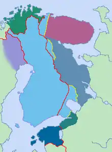
The idea of the book was to demonstrate scientifically that East Karelia and Ingermanland are a natural part of Finland by their geography, history and culture and to legitimize their integration into Finland after Germany's victory in World War II. The new eastern border of Finland was defined to begin from the Gulf of Finland and run via lakes Ladoga and Onega to Onega Bay in the White Sea. An unpublished adaptation of the book also featured the residential areas of Finnic Kvens in the Norwegian county of Finnmark.[1]
The original title of Finnlands Lebensraum was Das geographische und geschichtliche Finnland (The Geographic and Historic Finland) but it was changed by the German publisher to fit more into the Nazi ideology.[1]
See also
References
- Poikonen, Jaakko "Suur-Suomea perustamassa" Poleemi 4/2006, p. 24-27 (in Finnish). Retrieved November 12, 2013.
