Flå
Flå is a municipality in Viken county, Norway. The administrative centre of the municipality is the village of Flå. The municipality of Flå was established when it was separated from the municipality of Nes on 1 January 1905. The municipality lies at the most southeasterly point in the valley and traditional region of Hallingdal.
Flå kommune | |
|---|---|
 | |
 Coat of arms 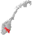 Viken within Norway | |
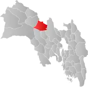 Flå within Viken | |
| Coordinates: 60°24′31″N 9°29′3″E | |
| Country | Norway |
| County | Viken |
| District | Hallingdal |
| Administrative centre | Flå |
| Government | |
| • Mayor (2003) | Tor Egil Buøen (LL) |
| Area | |
| • Total | 704 km2 (272 sq mi) |
| • Land | 670 km2 (260 sq mi) |
| Area rank | 159 in Norway |
| Population (2008) | |
| • Total | 974 |
| • Rank | 405 in Norway |
| • Density | 1.5/km2 (4/sq mi) |
| • Change (10 years) | −12.9% |
| Demonym(s) | Fløværing[1] |
| Time zone | UTC+01:00 (CET) |
| • Summer (DST) | UTC+02:00 (CEST) |
| ISO 3166 code | NO-3039 |
| Official language form | Bokmål[2] |
| Website | www |
General information
Name
The Old Norse form of the name was Flóða sokn (sokn means parish). This is the plural genitive case of flœð meaning "flood" (probably because flooding has been a problem for many farms in the river valley). Prior to 1921, the name was written "Flaa".
Coat-of-arms
The coat-of-arms is from modern times. They were granted on 1 March 1985. The arms show a black bear on a gray/silver background. This was chosen because there used to be many bears in the Vassfaret area. Prior to 1985, the municipality used a logo with a bear walking through the area.[3][4]
| Ancestry | Number |
|---|---|
| 28 | |
| 28 | |
| 12 |
History
Ancient routes went to Vestlandet through Valdres and Hallingdal and down Røldal to Odda. Reflecting this route, Hallingdal and its neighboring valley of Valdres in Oppland to the north were originally populated by migrants from Vestlandet and spoke a western dialect. In recognition of this, Cardinal Nicholas Breakespear, who was in Scandinavia as papal legate in 1153, included Hallingdal in the diocese of Stavanger.[6]
Geography
Flå is the southernmost municipality within Hallingdal and forms the gateway to Hallingdal from the south. Flå is bordered in the north by Sør-Aurdal, in the east by Ringerike, in the south by Krødsherad and Sigdal, in the west by Nore og Uvdal, and in the northwest by Nes. Travelers from the south pass through the 65 m long tunnel Hallingporten on Norwegian National Road 7 (Riksvei 7) just located north of Gulsvik.
Vassfaret is a forested mountain valley bordering Flå. The Norefjell mountain range also includes parts of Flå as well as Nes, Ringerike and Sør-Aurdal municipalities. Lake Krøderen (Krøderfjord) stretches about 41 km north from the village of Krøderen and reaches to Gulsvik. The Hallingdalselva river flows into the lake from the north. The area includes the Vassfaret and Vidalen Conservation area which includes Festningen Nature Reserve and Bukollen Nature Reserve as well as the Inner Vassfaret Conservation area which includes Bringen Nature Reserve.[7] .[8]
Notable people
- Kolbjørn Buøen (1895–1975) a Norwegian actor [9]
- Fredrik Gulsvik (born 1989) a Norwegian former footballer with over 100 club caps
Attractions
Bjørneparken is located on Vikberget in Flå. The park is a sanctuary featuring various animals including bears, elk, deer, wolf, and lynx.[10]
Protected areas
See also
Gallery
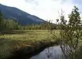 Vidalen
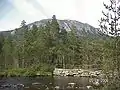 Bukollen
 Stavnselva
 Lake Krøderen
 Flå Church
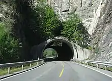 Hallingporten road tunnel
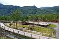 Bjørneparken
References
- "Navn på steder og personer: Innbyggjarnamn" (in Norwegian). Språkrådet.
- "Forskrift om målvedtak i kommunar og fylkeskommunar" (in Norwegian). Lovdata.no.
- Norske Kommunevåpen (1990). "Nye kommunevåbener i Norden". Retrieved 2009-01-06.
- "Kommunevåpen for Flå kommune" (in Norwegian). Flå kommune. Archived from the original on 2011-07-24. Retrieved 2009-01-06.
- "Immigrants and Norwegian-born to immigrant parents, by immigration category, country background and percentages of the population". ssb.no. Archived from the original on 2 July 2015. Retrieved 29 June 2015.
- Stagg, Frank Noel (1956). East Norway and its Frontier. George Allen & Unwin, Ltd.
- "Vassfaret og Vidalen landskapsvernområde". naturbase.no. Retrieved December 1, 2017.
- "Indre Vassfaret landskapsvernområde". naturbase.no. Retrieved October 1, 2017.
- IMDb Database retrieved 15 August 2020
- "Om Bjørneparken". Bjørneparken AS. Retrieved December 1, 2017.
- "Bringen naturreservat". naturbase.no. Retrieved October 1, 2017.
- "Bukollen naturreservat". naturbase.no. Retrieved October 1, 2017.
- "Festningen naturreservat". naturbase.no. Retrieved October 1, 2017.
- "Flenten naturreservat". naturbase.no. Retrieved October 1, 2017.
- "Stavnselva naturreservat". naturbase.no. Retrieved October 1, 2017.
External links
 Media related to Flå at Wikimedia Commons
 The dictionary definition of Flå at Wiktionary
- Municipal fact sheet from Statistics Norway
 Buskerud travel guide from Wikivoyage
- Culture in Flå on the map from Kulturnett.no
 |  | ||||||||||||||||||||||||||||||||||||||||
|