Flevopolder
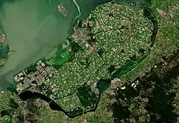
The Flevopolder is an island polder forming the bulk of Flevoland, a province of the Netherlands. Created by land reclamation, its northeastern part was drained in 1955 and the remainder—the southwest—in 1968.
 The Flevopolder | |
| Geography | |
|---|---|
| Location | Flevoland |
| Coordinates | 52°30′N 5°28′E |
| Area | 970 km2 (370 sq mi) |
| Administration | |
| Largest settlement | Almere [1] (pop. 202,764) |
| Demographics | |
| Population | 317,000 |
Boundaries
Unlike other major polders, such as Noordoostpolder and Wieringermeer, the Flevopolder is surrounded by bordering lakes or below-sea-level channels. These are the IJsselmeer, the Veluwemeer, Ketelmeer, and Gooimeer. It is the largest artificial island in the world.[2][3]
History
Reclamation of its land
Levees and dikes were first built around the polder. However, unlike similar projects, the internal water was then drained by diesel and electric pumps.
Etymology
Its name refers to the ancient Lake Flevo.
Geography
The Flevopolder together with the Noordoostpolder forms the province of Flevoland, the most recent province to be added to the Netherlands. Its southwestern point is close to Amsterdam and its opposite end is close to Kampen, Overijssel. It has three highly dominant settlements in terms of distribution of population.
References
- "Bevolkingsontwikkeling; regio per maand" [Population growth; regions per month]. CBS Statline (in Dutch). CBS. 1 January 2019. Retrieved 1 January 2019.
- "How a Nazi Blockade Triggered a Food Revolution". Bloomberg News via YouTube. November 2, 2018.
- "Dutch Flevoland - The Largest Man-Made Island". www.tourism-review.com. 28 April 2014. Retrieved 22 November 2015.
