Flint Cross
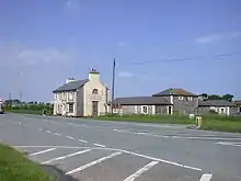
Flint Cross is a hamlet and crossroads in South Cambridgeshire, in the English county of Cambridgeshire. It is in the south of the district, where the east-west A505 road meets the B1368 road, which leads north to Fowlmere and south to Barley, Hertfordshire. In both main definitions of parish, in England, it is in Melbourn.

Position
Nearby notable settlements are the town of Royston and the villages of Fowlmere and Duxford.
Landmarks
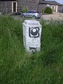
The milestone at Flint Cross, installed in 1731, is Grade II listed.[1] It has a benchmark inscribed on the side, currently at 39.9693 metres (131.133 ft) above mean sea level and stated by Ordnance Survey maps to be 132.3 feet above Ordnance Datum.[2] It is one of a series of waymarked milestones from Cambridge to Barkway, which were installed through a bequest from William Mowse, a lawyer who was Master of Trinity Hall, Cambridge in 1552, whose coat of arms each bear.
Buildings include the Coach House hotel.[3] and a petrol station. The hamlet is also the site of Bridgefoot Quarry[4] and Grange Farm, which was damaged by a fire in June 2009.[5] The Anglo-Saxon earthwork of Bran Ditch is to the east but has been mostly ploughed out.
The A505 here saw a series of traffic accidents.[4] A road safety scheme was implemented in October 2010 following a local campaign; however, a proposed reduction in the road's speed limit to 50 mph was not initially included.[6] The speed limit was imposed following a consultation.[7]
Civil parishes
The place is in the south of Melbourn,[1][8] as to civil parish, save for Bridgefoot Farm and houses west in Great and Little Chishill.[8]
Ecclesiastical parishes
The same, main, part is in Church of England parish of Melbourn that has identical boundaries;[9] however the south part is in a six-church-cluster parish: Icknield Way Villages.[9] Melbourn shares its cleric with Meldreth (see Shingay Deanery) and is in the Diocese of Ely. The other part is in the Diocese of Chelmsford.[9] In the Catholic church the relevant churches are in the Deanery of Cambridge, being between Cambourne and Sawston churches, which have a joint parish regular newsletter.[10]
References
- Historic England. "Milestone at Junction of A505 and B1368 (1127567)". National Heritage List for England. Retrieved 8 April 2014.
- Ordnance Survey map of Cambridgeshire, at six inches to the mile, sheet LVIII.SE, Revised: 1896 to 1901, Published: 1904
- "Coach House Hotel website". Archived from the original on 13 April 2014. Retrieved 9 April 2014.
- "Peterborough City Council - Minerals and Waste Site Specific Proposals Preferred Options 2". Archived from the original on 13 August 2011. Retrieved 27 October 2010.
- "Ten crews battle fire at converted barn: Royston Weekly News".
- "Sprayed signs leave councillor confused - News - Royston Crow".
- "Speed limits to reduce on major roads: Royston Crow".
- [https://maps.nls.uk/geo/explore/#zoom=15&lat=52.07000&lon=0.04700&layers=168&b=7 National Libraries of Scotland (nls.uk) interactive maps of Britain, explore overlays, OS 1920s, Open Street Map.
- https://www.achurchnearyou.com/search/?lat=52.07&lon=0.047 Church of England parish maps and church finder
- Diocese of East Anglia church map
| Wikimedia Commons has media related to Flint Cross. |
- Philip's Street Atlas Cambridgeshire