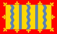
Cambridgeshire
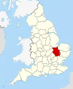
Cambridgeshire (abbreviated Cambs.)[note 1] is a county in the East of England, bordering Lincolnshire to the north, Norfolk to the north-east, Suffolk to the east, Essex and Hertfordshire to the south, and Bedfordshire and Northamptonshire to the west. The city of Cambridge is the county town. Modern Cambridgeshire was formed in 1974 through the amalgamation of two administrative counties: Cambridgeshire and Isle of Ely, comprising the historic county of Cambridgeshire (including the Isle of Ely); and Huntingdon and Peterborough, comprising the historic county of Huntingdonshire and the Soke of Peterborough, historically part of Northamptonshire. Cambridgeshire contains most of the region known as Silicon Fen.
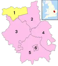
The county is now divided between Cambridgeshire County Council and Peterborough City Council, which since 1998 has formed a separate unitary authority. In the county there are five district councils, Cambridge City Council, East Cambridgeshire District Council, Fenland District Council, Huntingdonshire District Council and South Cambridgeshire District Council.[4]
History
Cambridgeshire is noted as the site of Flag Fen in Fengate, one of the earliest-known Neolithic permanent settlements in the United Kingdom, compared in importance to Balbridie in Aberdeen, Scotland. Must Farm quarry, at Whittlesey has been described as 'Britain's Pompeii due to its relatively good condition, including the 'best-preserved Bronze Age dwellings ever found'. A great quantity of archaeological finds from the Stone Age, the Bronze Age and the Iron Age were made in East Cambridgeshire. Most items were found in Isleham.[5]
The area was settled by the Anglo-Saxons starting in the fifth century. Genetic testing on seven skeletons found in Anglo-Saxon era graves in Hinxton and Oakington found that five were either migrants or descended from migrants from the continent, one was a native Briton, and one had both continental and native ancestry, suggesting intermarriage.[6]
Cambridgeshire was recorded in the Domesday Book as "Grantbridgeshire" (or rather Grentebrigescire) (related to the river Granta).
Covering a large part of East Anglia, Cambridgeshire today is the result of several local government unifications. In 1888 when county councils were introduced, separate councils were set up, following the traditional division of Cambridgeshire, for
- the area in the south around Cambridge, and
- the liberty of the Isle of Ely.
In 1965, these two administrative counties were merged to form Cambridgeshire and the Isle of Ely.[7] Under the Local Government Act 1972 this merged with the county to the west, Huntingdon and Peterborough, which had been formed in 1965, by the merger of Huntingdonshire with the Soke of Peterborough (the latter previously a part of Northamptonshire with its own county council). The resulting county was called simply Cambridgeshire.[8]
Since 1998, the City of Peterborough has been a separately administered area, as a unitary authority. It is associated with Cambridgeshire for ceremonial purposes such as Lieutenancy, and joint functions such as policing and the fire service.[9]
In 2002, the conservation charity Plantlife unofficially designated Cambridgeshire's county flower as the Pasqueflower.[10]
The Cambridgeshire Regiment (nicknamed the Fen Tigers), the county-based army unit, fought in the Boer War in South Africa, the First World War and Second World War [11]
Due to the county's flat terrain and proximity to the continent, during the Second World War the military built many airfields here for RAF Bomber Command, RAF Fighter Command, and the allied USAAF. In recognition of this collaboration, the Cambridge American Cemetery and Memorial is located in Madingley. It is the only WWII burial ground in England for American servicemen who died during that event.
Most English counties have nicknames for their people, such as a "Tyke" from Yorkshire and a "Yellowbelly" from Lincolnshire. The traditional nicknames for people from Cambridgeshire are "Cambridgeshire Camel"[12] or "Cambridgeshire Crane", referring to the wildfowl that were once abundant in the fens. The term "Fen Tigers" is sometimes used to describe the people who live and work in the fenlands.[13] Original historical documents relating to Cambridgeshire are held by Cambridgeshire Archives and Local Studies.
Geography
- See also Geology of Cambridgeshire
Large areas of the county are extremely low-lying and Holme Fen is notable for being the UK's lowest physical point at 2.75 m (9 ft) below sea level. The highest point of the modern administrative county is in the village of Great Chishill at 146 m (480 ft) above sea level. However, this parish was historically a part of Essex, having been moved to Cambridgeshire in boundary changes in 1895. The historic county top is close to the village of Castle Camps where a point on the disused RAF airfield reaches a height of 128 metres (420 ft) above sea level (grid reference TL 63282 41881).
Other prominent hills are Little Trees Hill and Wandlebury Hill (both at 74 m (243 ft)) in the Gog Magog Hills, Rivey Hill above Linton, Rowley's Hill and the Madingley Hills.
Green belt
Cambridgeshire contains all its green belt around the city of Cambridge, extending to places such as Waterbeach, Lode, Duxford, Little & Great Abington and other communities a few miles away in nearby districts, to afford a protection from the conurbation. It was first drawn up in the 1950s.
Politics
Cambridgeshire contains seven Parliamentary constituencies:
| Constituency | Member of Parliament | |
|---|---|---|
| Cambridge | Daniel Zeichner | |
| Huntingdon | Jonathan Djanogly | |
| North East Cambridgeshire | Stephen Barclay | |
| North West Cambridgeshire | Shailesh Vara | |
| Peterborough | Paul Bristow | |
| South Cambridgeshire | Anthony Browne | |
| South East Cambridgeshire | Lucy Frazer | |
Economy
This is a chart of trend of regional gross value added of Cambridgeshire at current basic prices published (pp. 240–253) by Office for National Statistics with figures in millions of English Pounds Sterling.
| Year | Regional Gross Value Added[note 2] | Agriculture[note 3] | Industry[note 4] | Services[note 5] |
|---|---|---|---|---|
| 1995 | 5,896 | 228 | 1,646 | 4,022 |
| 2000 | 7,996 | 166 | 2,029 | 5,801 |
| 2003 | 10,154 | 207 | 2,195 | 7,752 |
AWG plc is based in Huntingdon. The RAF has several stations in the Huntingdon and St Ives area. RAF Alconbury, 3 miles north of Huntingdon, is being reorganised after a period of obsolescence following the departure of the USAF, to be the focus of RAF/USAFE intelligence operations, with activities at Upwood and Molesworth being transferred there. Most of Cambridgeshire is agricultural. Close to Cambridge is the so-called Silicon Fen area of high-technology (electronics, computing and biotechnology) companies. ARM Limited is based in Cherry Hinton.
Education
Primary and secondary
Cambridgeshire has a completely comprehensive education system with 12 independent schools and over 240 state schools, not including sixth form colleges.
Some of the secondary schools act as Village Colleges, institutions unique to Cambridgeshire. For example, Bottisham Village College.
Tertiary
Cambridgeshire is home to a number of institutes of higher education:
- The University of Cambridge – second-oldest university in the English-speaking world, and regarded as one of the most prestigious academic institutions in the world
- Anglia Ruskin University – has a campus located in Cambridge and a base at Fulbourn
- The Open University – has a regional centre located in Cambridge
- The University Centre Peterborough – operated by Anglia Ruskin University and Peterborough Regional College, located in Peterborough
- The College of West Anglia has a campus at Milton, on the northern outskirts of Cambridge and a campus at Wisbech.
In addition, Cambridge Regional College and Huntingdonshire Regional College both offer a limited range of higher education courses in conjunction with partner universities.
Settlements
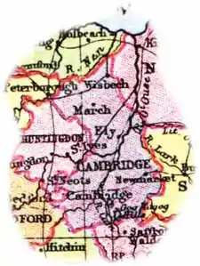
These are the settlements in Cambridgeshire with a town charter, city status or a population over 5,000; for a complete list of settlements see list of places in Cambridgeshire.
- Burwell
- Cambridge
- Chatteris
- Cottenham
- Ely
- Godmanchester
- Huntingdon
- Littleport
- March
- Peterborough
- Ramsey
- Sawston
- Sawtry
- Soham
- St Ives
- St Neots
- Wisbech
- Whittlesey
- Yaxley
See the List of Cambridgeshire settlements by population page for more detail.
The town of Newmarket is surrounded on three sides by Cambridgeshire, being connected by a narrow strip of land to the rest of Suffolk.
Cambridgeshire has seen 32,869 dwellings created from 2002 to 2013[14] and there are a further 35,360 planned new dwellings between 2016 and 2023.[15]
Climate
Cambridgeshire has a maritime temperate climate which is broadly similar to the rest of the United Kingdom, though it is drier than the UK average due to its low altitude and easterly location, the prevailing southwesterly winds having already deposited moisture on higher ground further west. Average winter temperatures are cooler than the English average, due to Cambridgeshire's inland location and relative nearness to continental Europe, which results in the moderating maritime influence being less strong. Snowfall is slightly more common than in western areas, due to the relative winter coolness and easterly winds bringing occasional snow from the North Sea. In summer temperatures are average or slightly above, due to less cloud cover. It reaches 25 °C (77 °F) on around 10 days each year, and is comparable to parts of Kent and East Anglia.
| Climate data for Cambridge University Botanic Garden[lower-alpha 1], elevation: 13 m (43 ft), 1981–2010 normals, extremes 1914–present | |||||||||||||
|---|---|---|---|---|---|---|---|---|---|---|---|---|---|
| Month | Jan | Feb | Mar | Apr | May | Jun | Jul | Aug | Sep | Oct | Nov | Dec | Year |
| Record high °C (°F) | 14.9 (58.8) |
18.8 (65.8) |
23.9 (75.0) |
27.4 (81.3) |
31.1 (88.0) |
34.0 (93.2) |
38.7 (101.7) |
36.9 (98.4) |
33.9 (93.0) |
29.3 (84.7) |
21.1 (70.0) |
15.8 (60.4) |
38.7 (101.7) |
| Average high °C (°F) | 7.4 (45.3) |
8.0 (46.4) |
11.1 (52.0) |
13.8 (56.8) |
17.5 (63.5) |
20.4 (68.7) |
23.1 (73.6) |
22.8 (73.0) |
19.6 (67.3) |
15.2 (59.4) |
10.5 (50.9) |
7.7 (45.9) |
14.8 (58.6) |
| Daily mean °C (°F) | 4.4 (39.9) |
4.6 (40.3) |
7.1 (44.8) |
9.1 (48.4) |
12.4 (54.3) |
15.3 (59.5) |
17.8 (64.0) |
17.5 (63.5) |
14.8 (58.6) |
11.2 (52.2) |
7.2 (45.0) |
4.7 (40.5) |
10.5 (50.9) |
| Average low °C (°F) | 1.4 (34.5) |
1.2 (34.2) |
3.0 (37.4) |
4.3 (39.7) |
7.3 (45.1) |
10.2 (50.4) |
12.4 (54.3) |
12.2 (54.0) |
10.0 (50.0) |
7.2 (45.0) |
3.9 (39.0) |
1.7 (35.1) |
6.2 (43.2) |
| Record low °C (°F) | −16.1 (3.0) |
−17.2 (1.0) |
−11.7 (10.9) |
−6.1 (21.0) |
−4.4 (24.1) |
−0.6 (30.9) |
2.2 (36.0) |
3.3 (37.9) |
−2.2 (28.0) |
−6.1 (21.0) |
−13.3 (8.1) |
−15.6 (3.9) |
−17.2 (1.0) |
| Average precipitation mm (inches) | 46.0 (1.81) |
34.6 (1.36) |
38.6 (1.52) |
40.3 (1.59) |
46.7 (1.84) |
52.1 (2.05) |
50.7 (2.00) |
53.6 (2.11) |
54.3 (2.14) |
57.7 (2.27) |
54.9 (2.16) |
46.9 (1.85) |
576.2 (22.69) |
| Average precipitation days (≥ 1.0 mm) | 10.7 | 8.4 | 9.9 | 8.9 | 8.1 | 9.2 | 8.4 | 8.2 | 8.4 | 9.5 | 10.2 | 9.7 | 109.6 |
| Source: KNMI[16] | |||||||||||||
| Climate data for Cambridge NIAB[lower-alpha 2], elevation: 26 m (85 ft), 1981–2010 normals | |||||||||||||
|---|---|---|---|---|---|---|---|---|---|---|---|---|---|
| Month | Jan | Feb | Mar | Apr | May | Jun | Jul | Aug | Sep | Oct | Nov | Dec | Year |
| Average high °C (°F) | 7.3 (45.1) |
7.7 (45.9) |
10.6 (51.1) |
13.3 (55.9) |
16.9 (62.4) |
19.9 (67.8) |
22.8 (73.0) |
22.6 (72.7) |
19.3 (66.7) |
14.9 (58.8) |
10.3 (50.5) |
7.5 (45.5) |
14.5 (58.1) |
| Daily mean °C (°F) | 4.5 (40.1) |
4.5 (40.1) |
6.9 (44.4) |
8.8 (47.8) |
12.0 (53.6) |
15.1 (59.2) |
17.6 (63.7) |
17.5 (63.5) |
14.9 (58.8) |
11.3 (52.3) |
7.3 (45.1) |
4.7 (40.5) |
10.4 (50.7) |
| Average low °C (°F) | 1.6 (34.9) |
1.3 (34.3) |
3.1 (37.6) |
4.3 (39.7) |
7.1 (44.8) |
10.2 (50.4) |
12.4 (54.3) |
12.4 (54.3) |
10.4 (50.7) |
7.6 (45.7) |
4.2 (39.6) |
1.9 (35.4) |
6.4 (43.5) |
| Average precipitation mm (inches) | 46.6 (1.83) |
34.5 (1.36) |
38.3 (1.51) |
41.2 (1.62) |
46.0 (1.81) |
51.5 (2.03) |
47.5 (1.87) |
50.8 (2.00) |
53.5 (2.11) |
59.0 (2.32) |
52.8 (2.08) |
46.4 (1.83) |
568.1 (22.37) |
| Average precipitation days (≥ 1.0 mm) | 10.5 | 8.0 | 9.6 | 8.8 | 8.0 | 8.9 | 8.3 | 8.0 | 8.4 | 9.4 | 9.8 | 9.8 | 107.5 |
| Mean monthly sunshine hours | 58.3 | 77.1 | 110.7 | 152.5 | 179.4 | 176.7 | 187.6 | 182.6 | 139.5 | 113.9 | 66.7 | 49.3 | 1,494.5 |
| Source: Met Office[17] | |||||||||||||
- Weather station is located 0.8 miles (1.3 km) from the Cambridge city centre.
- Weather station is located 3 miles (5 km) from the Cambridge city centre.
Culture
Sports
Various forms of football have been popular in Cambridgeshire since medieval times at least. In 1579 one match played at Chesterton between townspeople and Cambridge University students ended in a violent brawl that led the Vice-Chancellor to issue a decree forbidding them to play "footeball” outside of college grounds.[18] During the nineteenth century, several formulations of the laws of football, known as the Cambridge rules, were created by students at the University. One of these codes, dating from 1863, had a significant influence on the creation of the original laws of the Football Association.[19]
Cambridgeshire is also the birthplace of bandy,[20] now an IOC accepted sport.[21] According to documents from 1813, Bury Fen Bandy Club was undefeated for 100 years. A member of the club, Charles Goodman Tebbutt, wrote down the first official rules in 1882.[20] Tebbutt was instrumental in spreading the sport to many countries.[22] Great Britain Bandy Federation is based in Cambridgeshire.[23]
Fen skating is a traditional form of skating in the Fenland. The National Ice Skating Association was set up in Cambridge in 1879, they took the top Fen skaters to the worldspeed skating championships where James Smart became world champion.[24]
On 6–7 June 2015, the inaugural Tour of Cambridgeshire cycle race took place on closed roads across the county. The event was an official UCI qualification event, and consisted of a Time Trial on the 6th, and a Gran Fondo event on the 7th. The Gran Fondo event was open to the public, and over 6000 riders took part in the 128 km (80 mi) race.
There is only one racecourse in Cambridgeshire, located at Huntingdon.
Contemporary art
Cambridge is home to the Kettle's Yard gallery and the artist-run Aid and Abet project space. Nine miles west of Cambridge next to the village of Bourn is Wysing Arts Centre.[25] Cambridge Open Studios is the regions largest arts organisation with over 500 members. Every year, more than 370 artists open their doors to visitors during four weekends in July.[26]
Places of interest
| Key | |
| Abbey/Priory/Cathedral | |
| Accessible open space | |
| Amusement/Theme Park | |
| Castle | |
| Country Park | |
| English Heritage | |
| Forestry Commission | |
| Heritage railway | |
| Historic House | |
| Mosques | |
| Museum (free/not free) | |
| National Trust | |
| Theatre | |
| Zoo | |
- Anglesey Abbey


- Brampton Wood
- Buckden Towers

- Cambridge American Cemetery and Memorial
- Cambridge University Museum of Zoology
- Castor Hanglands NNR
- Cherry Hinton Chalk Pits
- Denny Abbey
- Devil's Dyke
- Down Field Windmill
- Duxford Chapel

- Duxford Airfield
- Elton Hall
- Ely Cathedral
- Fitzwilliam Museum, Cambridge
- Flag Fen
- Fowlmere RSPB reserve
- Gamsey Wood Nature Reserve
- Grafham Water Nature Reserve
- Great Gransden Post Mill
- Hereward Way
- Hinchingbrooke House
- Houghton Mill
- Icknield Way
- Imperial War Museum Duxford
.svg.png.webp)
- Kettle's Yard
- Kimbolton Castle
- King's College, Cambridge
- Lattersey Nature Reserve
- Lode Watermill
- Longthorpe Tower
- Magog Down
- March & District Museum
- Milton Country Park

- Nene Park
- Nene Valley Railway

- Nene Way
- New Bedford River
- Octavia Hill Birthplace Museum
- Old Bedford River
- Oliver Cromwell's House
- Ouse Valley Way
- Ouse Washes
- Parker's Piece, Cambridge, birthplace of modern football
- Paxton Pits Nature Reserve
- Peckover House & Garden
- Peterborough Cathedral
- Prickwillow Drainage Engine Museum
- Ramsey Abbey
- River Cam
- River Great Ouse
- River Nene
- Round Church, Cambridge
- RSPB Nene Washes
- RSPB Ouse Washes
- Stretham Old Engine
- Three Shires Bridleway
- University of Cambridge Museum of Archaeology and Anthropology
- Wandlebury Country Park
- Wicken Fen
- Wimpole Hall
- Wisbech Castle
- Wisbech & Fenland Museum
- Wisbech and March Bramley Line
- WWT Welney
- Wysing Arts Centre
See also
- List of Lord Lieutenants of Cambridgeshire
- List of High sheriffs of Cambridgeshire
- Custos Rotulorum of Cambridgeshire – Keepers of the Rolls for Cambridgeshire
- Cambridgeshire (UK Parliament constituency) – Historical list of MPs for Cambridgeshire constituency
- Cambridgeshire Archives and Local Studies
- Cambridgeshire local elections
- Healthcare in Cambridgeshire
- Cambridgeshire Constabulary
- Cambridgeshire Police and Crime Commissioner
Notes
- Archaically known as the County of Cambridge.[3]
- Components may not sum to totals due to rounding
- includes hunting and forestry
- includes energy and construction
- includes financial intermediation services indirectly measured
References
Citations
- "Lord Lieutenant". Archived from the original on 17 September 2017. Retrieved 22 January 2018.
- "No. 62943". The London Gazette. 13 March 2020. p. 5161.
- (EB 1878)
- "Local government in Cambridgeshire". Cambridgeshire County Council. Archived from the original on 19 August 2016. Retrieved 25 July 2016.
- Malim, Tim (September 2010). "The environmental and social context of the isleham hoard". The Antiquaries Journal. 90: 74. doi:10.1017/S0003581509990485.
- Stephan Schiffels and Duncan Sayer, Investigating Anglo-Saxon migration history with ancient and modern DNA (2017)
- The Cambridgeshire and Isle of Ely Order 1964 (SI 1964/366), see Local Government Commission for England (1958 - 1967), Report and Proposals for the East Midlands General Review Area (Report No.3), 31 July 1961 and Report and Proposals for the Lincolnshire and East Anglia General Review Area (Report No.9), 7 May 1965.
- The English Non-metropolitan Districts (Definition) Order 1972 (SI 1972/2039) Part 5: County of Cambridgeshire
- The Cambridgeshire (City of Peterborough) (Structural, Boundary and Electoral Changes) Order 1996 Archived 10 July 2014 at the Wayback Machine (SI 1996/1878), see Local Government Commission for England (1992), Final Recommendations for the Future Local Government of Cambridgeshire, October 1994 and Final Recommendations on the Future Local Government of Basildon & Thurrock, Blackburn & Blackpool, Broxtowe, Gedling & Rushcliffe, Dartford & Gravesham, Gillingham & Rochester upon Medway, Exeter, Gloucester, Halton & Warrington, Huntingdonshire & Peterborough, Northampton, Norwich, Spelthorne and the Wrekin, December 1995.
- "County Flowers". Daily Telegraph. 5 May 2004.
- "Cambridgeshire Regiment". www.cambridgeshireregiment1914-18.co.uk. Retrieved 27 February 2020.
- Grose (1790). Provincial Glossary.
- Francis Pryor (October 1991). Book of Flag Fen: prehistoric Fenland centre. Batsford. p. 18. ISBN 978-0-7134-6752-9.
- "Housing Development in Cambridgeshire 2013" (PDF). Archived from the original (PDF) on 24 December 2013. Retrieved 5 February 2016.
- "Dwelling Commitments in Cambridgeshire" (PDF). Archived from the original (PDF) on 24 December 2013. Retrieved 5 February 2016.
- "Indices Data - Cambridge (B. Gdns) Station 1639". KNMI. Retrieved 12 March 2019.
- "Cambridge NIAB 1981–2010 averages". Met Office. Retrieved 12 March 2019.
- Association, The Football. "Sorry. Something's wrong with the pitch. - Cambridgeshire FA". www.cambridgeshirefa.com. Archived from the original on 8 July 2011. Retrieved 2 January 2012.
-
- Harvey, Adrian (2005). Football: the First Hundred Years. London: Routledge. pp. 144–5. ISBN 0-415-35019-0. Archived from the original on 1 May 2017. Retrieved 3 July 2019.
- BBC. "A handy Bandy guide..." Archived from the original on 15 October 2015. Retrieved 9 June 2017.
- "Federation of International Bandy-Olympic". Internationalbandy.com. 12 August 2004. Archived from the original on 19 January 2012. Retrieved 25 September 2010.
- "Cambridgeshire – History – A handy Bandy guide". BBC. 21 February 2006. Archived from the original on 27 April 2009. Retrieved 25 September 2010.
- "Members - Federation of International Bandy". www.worldbandy.com. Archived from the original on 27 January 2017. Retrieved 25 February 2017.
- "Fen Skating Scrapbook". www.ousewashes.org.uk. Retrieved 9 December 2020.
- "cultunet". cultunet.com. 3 December 2012. Archived from the original on 29 April 2014. Retrieved 3 February 2013.
- https://www.camopenstudios.co.uk/
Sources
- Arnold, F. (1878), , in Baynes, T. S. (ed.), Encyclopædia Britannica, 4 (9th ed.), New York: Charles Scribner's Sons, pp. 726–728
External links
| Wikimedia Commons has media related to Cambridgeshire. |
- , Encyclopædia Britannica, 5 (11th ed.), 1911, pp. 97–99
- Cambridgeshire County Council
- Cambridgeshire Community Archive Network.
- Images of Cambridgeshire at the English Heritage Archive
- Cambridgeshire at Curlie
- Cambridge Military History Blog
- The Flag Institute: Cambridgeshire
Neighbouring counties | ||||||||||
|---|---|---|---|---|---|---|---|---|---|---|
| ||||||||||
| Unitary authorities | |
|---|---|
| Major settlements |
|
| Rivers | |
| Topics |
|
| Authority control |
|
|---|