Fontana, Kansas
Fontana is a city in south central Miami County, Kansas, United States and is part of the Kansas City metropolitan area.[6] As of the 2010 census, the city population was 224.[7] The name Fontana comes from the French word fontaine, meaning fountain or a spring-like water source. It was given to the small city from a spring near the town site.[8] Fontana's history as a community dates back to the early 19th century, however incorporation did not occur until 1889.[9]
Fontana, Kansas | |
|---|---|
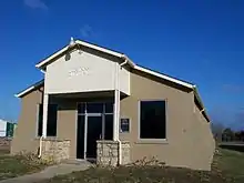
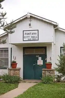 Fontana City Hall (2008) | |
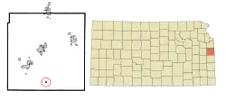 Location within Miami County and Kansas | |
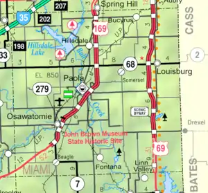 KDOT map of Miami County (legend) | |
| Coordinates: 38°25′33″N 94°50′17″W | |
| Country | United States |
| State | Kansas |
| County | Miami |
| Incorporated | 1889 |
| Area | |
| • Total | 0.84 sq mi (2.17 km2) |
| • Land | 0.84 sq mi (2.17 km2) |
| • Water | 0.00 sq mi (0.01 km2) |
| Elevation | 932 ft (284 m) |
| Population | |
| • Total | 224 |
| • Estimate (2019)[3] | 239 |
| • Density | 285.54/sq mi (110.28/km2) |
| Time zone | UTC-6 (CST) |
| • Summer (DST) | UTC-5 (CDT) |
| ZIP code | 66026 |
| Area code | 913 |
| FIPS code | 20-23650 [4] |
| GNIS ID | 0477629 [5] |
| Website | www |
History
Captain David Martin, a veteran of the War of 1812 received a land grant for 160 acres (0.65 km2) in Lykins County, Kansas (Miami County, Kansas) due to an 1855 congressional act. Part of this property would eventually become the townsite and rural community of Fontana. J.B. Grinnell purchased 120 acres (0.49 km2) of the property in 1869, and put Fontana in the center near a railroad right of way. The city was incorporated in 1889.[9]
Geography
Fontana has a total area of 0.84 square miles (2.18 km2), all of it land.[10]
Demographics
| Historical population | |||
|---|---|---|---|
| Census | Pop. | %± | |
| 1880 | 174 | — | |
| 1890 | 256 | 47.1% | |
| 1900 | 237 | −7.4% | |
| 1910 | 246 | 3.8% | |
| 1920 | 206 | −16.3% | |
| 1930 | 187 | −9.2% | |
| 1940 | 174 | −7.0% | |
| 1950 | 168 | −3.4% | |
| 1960 | 138 | −17.9% | |
| 1970 | 160 | 15.9% | |
| 1980 | 173 | 8.1% | |
| 1990 | 131 | −24.3% | |
| 2000 | 149 | 13.7% | |
| 2010 | 224 | 50.3% | |
| 2019 (est.) | 239 | [3] | 6.7% |
| U.S. Decennial Census | |||
2010 census
As of the census[2] of 2010, there were 224 people, 72 households, and 55 families residing in the city. The population density was 266.7 inhabitants per square mile (103.0/km2). There were 84 housing units at an average density of 100.0 per square mile (38.6/km2). The racial makeup of the city was 92.9% White, 0.4% African American, 0.4% Native American, 0.4% Asian, 2.7% from other races, and 3.1% from two or more races. Hispanic or Latino of any race were 6.7% of the population.
There were 72 households, of which 48.6% had children under the age of 18 living with them, 56.9% were married couples living together, 13.9% had a female householder with no husband present, 5.6% had a male householder with no wife present, and 23.6% were non-families. 19.4% of all households were made up of individuals, and 9.8% had someone living alone who was 65 years of age or older. The average household size was 3.11 and the average family size was 3.42.
The median age in the city was 32.2 years. 31.7% of residents were under the age of 18; 11.6% were between the ages of 18 and 24; 27.2% were from 25 to 44; 21.9% were from 45 to 64; and 7.6% were 65 years of age or older. The gender makeup of the city was 50.9% male and 49.1% female.
2000 census
As of the census[4] of 2000, there were 149 people, 61 households, and 46 families residing in the city. The population density was 854.6 people per square mile (338.4/km2). There were 67 housing units at an average density of 384.3 per square mile (152.2/km2). The racial makeup of the city was 97.32% White, 0.67% Native American, 0.67% from other races, and 1.34% from two or more races. Hispanic or Latino of any race were 2.01% of the population.
There were 61 households, out of which 21.3% had children under the age of 18 living with them, 65.6% were married couples living together, 9.8% had a female householder with no husband present, and 23.0% were non-families. 18.0% of all households were made up of individuals, and 13.1% had someone living alone who was 65 years of age or older. The average household size was 2.44 and the average family size was 2.72.
In the city, the population was spread out, with 20.8% under the age of 18, 10.7% from 18 to 24, 22.1% from 25 to 44, 28.2% from 45 to 64, and 18.1% who were 65 years of age or older. The median age was 43 years. For every 100 females, there were 79.5 males. For every 100 females age 18 and over, there were 90.3 males.
The median income for a household in the city was $29,375, and the median income for a family was $32,083. Males had a median income of $26,875 versus $13,000 for females. The per capita income for the city was $13,484. There were 5.4% of families and 12.7% of the population living below the poverty line, including 7.4% of under eighteens and 22.2% of those over 64.
Economy
With a farm-based economy, the Fontana Co-Op is of great importance to the area farmers.[9]
Education
The community is served by Prairie View USD 362 public school district. Students from grades 6–12 attend Prairie View Middle School or Prairie View High School in La Cygne, Kansas.
Previously, Fontana Elementary was located in Fontana, having a total enrollment of approximately 100 students from kindergarten through 5th grades. In approximately 2011, the Prairie View School Board expressed an interest in replacing or remodeling Fontana Elementary. Various proposals were made, including one to build a new school close to Prairie View Middle School, but the Board eventually settled on a decision to expand nearby Parker Elementary, which was part of Prairie View along with Fontana. The school ceased operations in May 2014, with the end of the school year, and all the students were moved to Parker Elementary. The school building has since been sold to private owners.
References
- "2019 U.S. Gazetteer Files". United States Census Bureau. Retrieved July 24, 2020.
- "U.S. Census website". United States Census Bureau. Retrieved 2012-07-06.
- "Population and Housing Unit Estimates". United States Census Bureau. May 24, 2020. Retrieved May 27, 2020.
- "U.S. Census website". United States Census Bureau. Retrieved 2008-01-31.
- "US Board on Geographic Names". United States Geological Survey. 2007-10-25. Retrieved 2008-01-31.
- https://www.marc.org/Data-Economy/Metrodataline/General-Information/Statistical-Areas
- "2010 City Population and Housing Occupancy Status". U.S. Census Bureau. Retrieved March 6, 2011.
- Gannett, Henry (1905). The Origin of Certain Place Names in the United States. Govt. Print. Off. pp. 128.
- "2009 Miami County Visitors Guide", page 18.
- "US Gazetteer files 2010". United States Census Bureau. Archived from the original on 2012-07-02. Retrieved 2012-07-06.
Further reading
External links
| Wikimedia Commons has media related to Fontana, Kansas. |
Municipalities and communities of Miami County, Kansas, United States | ||
|---|---|---|
| Cities | 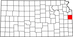 Map of Kansas highlighting Miami County | |
| Unincorporated communities | ||
| Footnotes | †This populated place is designated a Census-Designated Place (CDP) by the United States Census Bureau, ‡This populated place also has portions in an adjacent county or counties. | |
| ||
