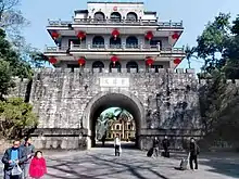
Friendship Pass
Friendship Pass (traditional Chinese: 友誼關; simplified Chinese: 友谊关; Vietnamese: Hữu Nghị Quan), also commonly known by its older name Ải Nam Quan (traditional Chinese: 隘南關; simplified Chinese: 隘南关), is a pass near the China-Vietnam border, between China's Guangxi and Vietnam's Lạng Sơn Province. The pass itself lies just inside the Chinese side of the border.[1][2]
| Friendship Pass | |||||||||||||
|---|---|---|---|---|---|---|---|---|---|---|---|---|---|
 | |||||||||||||
| Chinese name | |||||||||||||
| Traditional Chinese | 友誼關 | ||||||||||||
| Simplified Chinese | 友谊关 | ||||||||||||
| |||||||||||||
| Vietnamese name | |||||||||||||
| Vietnamese | Hữu Nghị Quan | ||||||||||||
Vietnamese National Route 1A starts at the border near this pass, which lies less than 5 km north of the town of Đồng Đăng in Lạng Sơn Province, ending in Năm Căn in Cà Mau Province. China National Highway 322 runs from here to Guangxi Province and Hunan Province. This is one of the busiest border trading points of Vietnam.
It was built in the early Ming dynasty with the name of "South Suppressing Pass" (traditional Chinese: 鎮南關; simplified Chinese: 镇南关; Vietnamese: Trấn Nam Quan). In 1953, its name was changed to "South Watching Pass" (traditional Chinese: 睦南關; simplified Chinese: 睦南关; Vietnamese: Mục Nam Quan). In 1965, its name was changed again to the current Friendship Pass, reflecting the close political, military, and economic ties between the People's Republic of China and North Vietnam during the then-ongoing Vietnam War.
History
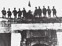
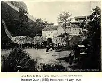
Traditionally, the pass served as the exact border between China and Vietnam,[1][2] hence there is also a Vietnamese historical saying: "Nước Việt Nam ta trải dài từ Ải Nam Quan đến mũi Cà Mau,"[3][4] translated as "The Vietnamese nation stretches from Ải Nam Quan to Cape Cà Mau". However, recently the pass has been in Chinese control and well within Chinese territory,[5] in Pingxiang, Chongzuo County, Guangxi Autonomous Region,[6] since the early 1950s, and the official border between the two nations is beyond this pass. The new border was later confirmed by Chinese and Vietnamese communist officials by a border treaty enacted in June 2000,[1] with Vietnamese officials stating that some Vietnamese territory along the Sino-Vietnamese border, namely in Cao Bằng Province and Lạng Sơn Province had been ceded to China.[2] This concession was unpopular among the Vietnamese populace.[7]
References
- "Archived copy". Archived from the original on 31 August 2014. Retrieved 6 October 2014.CS1 maint: archived copy as title (link)
- "In Westminster, an Internet Bid to Restore Viet Land". latimes. Retrieved 27 June 2015.
- "Asia Finest Discussion Forum > Ai Nam Quan - An example of communist sellout of Motherland". Archived from the original on 22 February 2014. Retrieved 27 June 2015.
- "Ải Nam Quan - nay còn đâu !! [Lưu Trữ] - Diễn đàn Lịch sử Việt Nam". Retrieved 27 June 2015.
- "Ải Nam Quan trong hiện tại phần 2". Retrieved 27 June 2015.
- "Google Maps". Google Maps. Retrieved 27 June 2015.
- "Archived copy". Archived from the original on 12 November 2016. Retrieved 8 April 2012.CS1 maint: archived copy as title (link)
External links
| Wikimedia Commons has media related to Friendship Pass. |