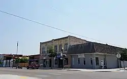
Fruitland, Idaho
Fruitland is a city in Payette County, Idaho, United States. It lies along U.S. Route 95 in the Treasure Valley of southwest Idaho, about 50 miles (80 km) west of Boise on the border with Oregon. It is part of the Ontario Micropolitan Area. Fruitland is named after apple orchards that surround the community, and its slogan is "The Big Apple of Idaho."
Fruitland, Idaho | |
|---|---|
 | |
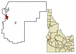 Location of Fruitland in Payette County, Idaho. | |
| Coordinates: 44°0′58″N 116°55′17″W | |
| Country | United States |
| State | Idaho |
| County | Payette |
| Area | |
| • Total | 2.16 sq mi (5.59 km2) |
| • Land | 2.15 sq mi (5.58 km2) |
| • Water | 0.01 sq mi (0.01 km2) |
| Elevation | 2,228 ft (679 m) |
| Population | |
| • Total | 4,684 |
| • Estimate (2019)[3] | 5,426 |
| • Density | 2,519.03/sq mi (972.42/km2) |
| Time zone | UTC-7 (Mountain (MST)) |
| • Summer (DST) | UTC-6 (MDT) |
| ZIP code | 83619 |
| Area code(s) | 208, 986 |
| FIPS code | 16-28990 |
| GNIS feature ID | 0396521 |
| Website | fruitland |
As of the 2010 census, the city had a total population of 4,684, up from 3,805 in 2000.[4]
Geography
Fruitland is located at 44°0′58″N 116°55′17″W (44.016035, -116.921450),[5] at an elevation of 2,228 feet (679 m) above sea level within the Snake River watershed.
According to the United States Census Bureau, the city has a total area of 2.24 square miles (5.80 km2), of which, 2.23 square miles (5.78 km2) is land and 0.01 square miles (0.03 km2) is water.[6]
Demographics
| Historical population | |||
|---|---|---|---|
| Census | Pop. | %± | |
| 1950 | 573 | — | |
| 1960 | 804 | 40.3% | |
| 1970 | 1,576 | 96.0% | |
| 1980 | 2,559 | 62.4% | |
| 1990 | 2,400 | −6.2% | |
| 2000 | 3,805 | 58.5% | |
| 2010 | 4,684 | 23.1% | |
| 2019 (est.) | 5,426 | [3] | 15.8% |
| U.S. Decennial Census[7] | |||
2010 census
As of the census[2] of 2010, there were 4,684 people, 1,700 households, and 1,243 families living in the city. The population density was 2,100.4 inhabitants per square mile (811.0/km2). There were 1,836 housing units at an average density of 823.3 per square mile (317.9/km2). The racial makeup of the city was 84.0% White, 0.5% African American, 1.0% Native American, 1.1% Asian, 0.1% Pacific Islander, 10.3% from other races, and 2.8% from two or more races. Hispanic or Latino of any race were 22.6% of the population.
There were 1,700 households, of which 42.5% had children under the age of 18 living with them, 55.0% were married couples living together, 12.8% had a female householder with no husband present, 5.3% had a male householder with no wife present, and 26.9% were non-families. 23.5% of all households were made up of individuals, and 12% had someone living alone who was 65 years of age or older. The average household size was 2.76 and the average family size was 3.26.
The median age in the city was 32.7 years. 31.7% of residents were under the age of 18; 7.8% were between the ages of 18 and 24; 25.4% were from 25 to 44; 21.1% were from 45 to 64; and 13.9% were 65 years of age or older. The gender makeup of the city was 48.8% male and 51.2% female.
2000 census
As of the census[8] of 2000, there were 3,805 people, 1,378 households, and 1,044 families living in the city. The population density was 2,512.2 people per square mile (972.9/km2). There were 1,518 housing units at an average density of 1,002.2 per square mile (388.1/km2). The racial makeup of the city was 87.70% White, 0.89% Asian, 0.60% Native American, 0.05% African American, 0.03% Pacific Islander, 8.02% from other races, and 2.71% from two or more races. Hispanic or Latino of any race were 17.92% of the population.
There were 1,378 households, out of which 40.6% had children under the age of 18 living with them, 58.1% were married couples living together, 13.1% had a female householder with no husband present, and 24.2% were non-families. 21.4% of all households were made up of individuals, and 10.6% had someone living alone who wais 65 years of age or older. The average household size was 2.76 and the average family size was 3.20.
In the city, the population was spread out, with 31.9% under the age of 18, 9.0% from 18 to 24, 27.6% from 25 to 44, 18.6% from 45 to 64, and 12.9% who were 65 years of age or older. The median age was 31 years. For every 100 females, there were 93.8 males. For every 100 females age 18 and over, there were 87.3 males.
The median income for a household in the city was $32,469, and the median income for a family was $36,614. Males had a median income of $31,419 versus $22,000 for females. The per capita income for the city was $14,488. About 8.3% of families and 11.9% of the population were below the poverty line, including 15.6% of those under the age of 18 and 14.0% of those 65 and older.
References
- "2019 U.S. Gazetteer Files". United States Census Bureau. Retrieved July 9, 2020.
- "U.S. Census website". United States Census Bureau. Retrieved 2012-12-18.
- "Population and Housing Unit Estimates". United States Census Bureau. May 24, 2020. Retrieved May 27, 2020.
- Spokesman-Review Archived 2017-04-21 at the Wayback Machine - 2010 census - Fruitland, Idaho - accessed 2011-12-23
- "US Gazetteer files: 2010, 2000, and 1990". United States Census Bureau. 2011-02-12. Retrieved 2011-04-23.
- "US Gazetteer files 2010". United States Census Bureau. Archived from the original on 2012-07-02. Retrieved 2012-12-18.
- "Census of Population and Housing". Census.gov. Retrieved June 4, 2015.
- "U.S. Census website". United States Census Bureau. Retrieved 2008-01-31.
External links
- Official website - City of Fruitland
- Fruitland Chamber of Commerce
- Payette County USGenWeb
Municipalities and communities of Payette County, Idaho, United States | ||
|---|---|---|
| Cities | Map of Idaho highlighting Payette County | |
| Unincorporated communities | ||
| ||
| Authority control |
|---|