Fuerte Island
Fuerte Island (Isla Fuerte) is a small coral island[1] in the Caribbean Sea off the northern coast of Colombia, Córdoba department, located south of the Gulf of Morrosquillo. It is located at a distance of 11 km from mainland Colombia. It is part of the chain of islands formed by the Rosario Islands, the Archipelago of San Bernardo and Tortuguilla.
.PNG.webp)
The island has very limited facilities for visitors.[1]
Geography
Fuerte Island is approximately 1 mile in diameter and 1.5 miles from north to south. The island has an area of 3.25 km² and an elevation of 12m. The island is encircled by reefs and some scattered rocks. Some of the rocks are visible above the water line.[2]
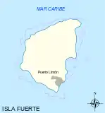 Map of Fuerte Island
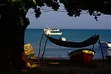 Puerto Limón, Fuerte Island
Flora and fauna
The island has trees spread throughout, with royal palm trees at its center that tower above the others.[2] The island has over 80 species of birds.
People
Island residents are mostly of African descent.
References
- Box, Ben (2013). Cartagena & Caribbean Coast. Footprint Travel Guides. p. 49. ISBN 1909268380.
- United States Hydrographic Office (1920). Central America and Mexico Pilot (East Coast) from Gallinas Point, Colombia, to the Rio Grande. U.S. Government Printing Office. pp. 68–69.
Further reading
- Marley, David (2008). Wars of the Americas. ABC-CLIO. p. 292. ISBN 1598841009.
- Area Handbook for Colombia. U.S. Government Printing Office. 1977. p. 19.
External links
- Isla Fuerte. Chinci World Atlas.
