Fuglenes
Fuglenes is a district in the municipality of Hammerfest in Norway.[1][2] It is the location of the northernmost point of the Struve Geodetic Arc. It is a geodetic point, one of the 34 points selected for the World Heritage List. It was here that Friedrich Georg Wilhelm von Struve's surveys ended in 1852. Fuglenes means 'the birds' in Norwegian.
Fuglenes | |
|---|---|
District | |
 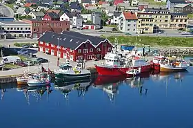 From top left to right: Northernmost station of the Struve Geodetic Arc, Fuglenes light beacon, Hammerfest Harbour at Fuglenes Peninsula | |
| Coordinates: 70.67°N 23.663333°E | |
| Country | Norway |
| County | Troms og Finnmark |
| Municipality | Hammerfest |
| Time zone | UTC+01:00 (CET) |
| • Summer (DST) | UTC+02:00 (CEST) |
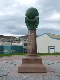
The meridian support
The meridian support was designed by Wilhelm von Hanno and erected in 1854 to commemorate the largest international measurement of the earth's shape and size. The meridian support with plinth, column, chapter, globe is an example of which styles von Hanno was inspired by.
The shelf is in three parts and in unpolished granite. While the two lower parts are almost square, the upper part is softly leaf-shaped, where the tip of the leaf forms corners and points towards the directions north, west, south and east. In a circular base on this upper part of the shelf rests the column. This polished granite column becomes slimmer in diameter with height.
The capital, which is the upper part of this classic pillar and in brass, forms quadrilaterals that also point to the south, north, east and west. The figures that characterize each corner have 4 faces. Two older faces with beards and two younger ones. The faces of the faces are shaped so that it can look like they are blowing. The younger ones are directed to the north and east, while the older ones to the west and south. The faces with their blowing mouths can be symbols of the different wind directions.
The northeast and southwest sides of the chapter have a clearly shaped coat of arms with the famous Norwegian lion, it may have been the forerunner of Norway's national coat of arms in 1905.
The globe must once have been a stately globe made of double copper plates, with the continents colored in brown and the sea in green. The mountain ranges rise in all parts of the world heritage. 163–164 years ago, the slaves at Akershus Fortress performed the work. At the top, the northern point is marked with a point pointing up.
The survey was initiated by Wilhelm Struve who received support from King Oscar I of Norway-Sweden and Alexander I of Russia
The meridian support is on the UNESCO list and is a protected cultural monument. The meridian support has the following inscription: [translated in English] “The northernmost endpoint of a meridian arc of 25 ° 20`from the northern ocean to the Danube river - through Norway, Sweden and Russia. By arrangement of HM Oscar I and Emperors Alexander I and Nicolaus I by uninterrupted geometries. Latitude 70 ° 40` 11.3``”.
Other notable buildings/landmarks
- Fuglenes Lighthouse, lighthouse which was established in 1859, and deactivated in 1911, when it was replaced by a light.[3][4]
- Fuglenes School (Norwegian skole), public primary school which has 193 students in 8 school classes, from first to seventh grade.[5] The school principal is Turid Leseth.
- Skansen på Fuglenes, historic landmark.
Notable people
- Charles Robertson (1875–1958), Norwegian Minister of Trade 1926–1928.[6]
References
- "Fuglenes, Norway". Geographical Names, map, geographic coordinates. Retrieved 2020-10-12.
- The World Air Quality Index project (2020-06-20). "Air Pollution in Fuglenes, Hammerfest, Norway: Real-time Air Quality Index Visual Map". Beijing Air Pollution. Retrieved 2020-10-12.
- Godal, Anne Marit (ed.). "Fuglenes". Store norske leksikon (in Norwegian). Norsk nettleksikon. Retrieved 11 October 2020.
- "Fuglenes fyrstasjon" (in Norwegian). Norsk Fyrhistorisk Forening. Retrieved 11 October 2020.
- "Fuglenes skole". Fuglenes skole (in Norwegian). 2020-09-25. Retrieved 2020-10-12.
- "Norsk senter for forskningsdata AS". NSD (in Norwegian). Retrieved 2020-10-12.
