Gadarwara
Gadarwara is a city and a municipality since 1867 in Narsinghpur district in the state of Madhya Pradesh, India. population of 43,000 in 2011.
Gadarwara | |
|---|---|
City | |
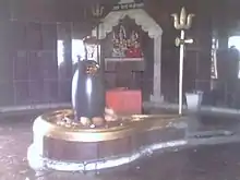
 Damru Ghati (Shiv Temple) | |
 Gadarwara Location in Madhya Pradesh, India | |
| Coordinates: 22.92°N 78.78°E | |
| Country | |
| State | Madhya Pradesh |
| Administrative Division | Jabalpur Division |
| District | Narsinghpur |
| Government | |
| • Type | Mayor–Council |
| • Body | Gadarwara Municipalality |
| Area | |
| • Total | 100 km2 (40 sq mi) |
| Elevation | 342 m (1,122 ft) |
| Population (2011*) | |
| • Total | 43,000 |
| • Density | 430/km2 (1,100/sq mi) |
| Languages | |
| • Official | Hindi |
| Time zone | UTC+5:30 (IST) |
| PIN | 487551 |
| Telephone code | 07791 |
| Vehicle registration | MP-49 |
| Website | www |
Goddess Bijasen Temple, Ram Mandir, Badi Mata Temple, Marhai Mata Temple, Jain Temple are present in the city. The city's major temple, Damru Ghaanti, with its large statue of Shiva and Shivalinga, receives thousands of devotees each year for the festival of Mahashivaratri.
Gadarwara is the childhood home of Osho (Bhagwan Shree Rajneesh) and has become a tourist destination for American, Australian and European pilgrims as well as Indians. There is a small ashram and a few spots associated with his early life.
Local administration
In 1901, The town was the headquarters of the district in the time of the Maratha Empire with a population of 6,198. Gadarwara was created as a municipality in 1867 under the British Raj and Police Thana and Tehsildar were appointed during the British Raj.
Current setup includes the following
Local governance
There are 26 wards in the city, among them Gadarwara Ward No 19 is the most populous ward with population of 2706 and Imaliya (og) Ward No 25 (rural Mdds Code:490767) is the least populous ward with population of 527.
Civil administration
Sub-Divisional Magistrate and Tehsildar office.
Law and order
Gadarwara Police Thana with the office of the Deputy Superintendent
of Police (DSP). In addition, there is also railway police Thana of Railway Protection Force.
Judiciary: There is an office of the Civil Judge.
Geography
Gadarwara is located at 22.92°N 78.78°E.[1] It has an average elevation of 354.77 metres (1,163 feet).
Gadarwara lies on the main road from Jabalpur to Mumbai 30 miles west of Narsinghpur civil station. 50 km away, the hill station of Panchmari draws visitors from all over India.
The Shakkar River flows through it rendering the surrounding farmland fertile. The larger Narmada River is 12 km away.
Climate
Gadarwara has a humid subtropical climate typical of north-central India (Madhya Pradesh and southern Uttar Pradesh). Summer begins in late March, lasting until June. May is the hottest month, with the average temperature exceeding 45 °C (113 °F). Summer is followed by the southwest monsoon, which lasts until early October and produces 35 inches (889 mm) of rain from July to September. Average annual precipitation is nearly 55 in (1386 mm). Winter begins in late November, and lasts until early March. January is the coldest month, with an average daily temperature near 15 °C (59 °F).
| Climate data for Gadarwara | |||||||||||||
|---|---|---|---|---|---|---|---|---|---|---|---|---|---|
| Month | Jan | Feb | Mar | Apr | May | Jun | Jul | Aug | Sep | Oct | Nov | Dec | Year |
| Average high °C (°F) | 24.5 (76.1) |
28.8 (83.8) |
34.3 (93.7) |
38.7 (101.7) |
40.4 (104.7) |
36.2 (97.2) |
30.3 (86.5) |
28.2 (82.8) |
30.9 (87.6) |
32.4 (90.3) |
29.7 (85.5) |
25.5 (77.9) |
31.7 (89.0) |
| Average low °C (°F) | 8.5 (47.3) |
11.4 (52.5) |
16.2 (61.2) |
21.2 (70.2) |
24.4 (75.9) |
24.1 (75.4) |
22.6 (72.7) |
21.9 (71.4) |
21.1 (70.0) |
18.1 (64.6) |
13.9 (57.0) |
9.6 (49.3) |
17.7 (64.0) |
| Average precipitation mm (inches) | 22.2 (0.87) |
23.4 (0.92) |
15.5 (0.61) |
7.7 (0.30) |
12.9 (0.51) |
167.3 (6.59) |
421.9 (16.61) |
422.9 (16.65) |
200.1 (7.88) |
39.9 (1.57) |
15.0 (0.59) |
9.9 (0.39) |
1,358.7 (53.49) |
| Average precipitation days | 0.8 | 0.8 | 0.3 | 0.3 | 1.8 | 8.6 | 15.9 | 18.3 | 8.6 | 3.1 | 1.4 | 0.6 | 60.5 |
| Mean monthly sunshine hours | 288.3 | 274.4 | 288.3 | 306.0 | 325.5 | 210.0 | 105.4 | 80.6 | 180.0 | 269.7 | 273.0 | 282.1 | 2,883.3 |
| Source: HKO | |||||||||||||
Demography
In 1901, town population was 6,198 under the Maratha Empire. Population rose to 25,529 in 1991, 37,861 in 2001, 1,05,726 in 2011 and 1,25,068 in 2019.[2]
Economy and industry
Historical trade in grain, cotton and cloth
Historically the town has manufactured and dyed cotton cloth, and functioned as a center of trade in grain and cotton from eastern Bhopal, Bhilsa, Sagar and elsewhere, exporting salt, crude sugar and piece-goods, particularly brass and bell-metal vessels made at Chichli.
Center of pulse production
Gadarwara is famous for production of pulses and has approximately ninety production mills: most varieties of lentils are available in this small town. Sugarcane is also produced in the area.
Economy of coal mines
A large coal mine known as Gotetoria is found some 15 km from the city. A railway station is situated 2 miles south of the town centre, whence a branch railway runs to the Mohpani coal-fields 14 miles farther south-south-east in the gorge by which the Chita-Rewa leaves the Satpura table-land.
Power generation: Gadarwara Super Thermal Power Plant
NTPC (national thermal power corporation) built an 800*4=3200 MW Coal Based Super Thermal Power Plant spread over 900 acres near Gangai village in Gadarwara Tehsil.
Coal requirement of 7.5 MTPA (Million Tons Per Annum) which will be obtained from the North Karanpura Coalfield. The water requirement of 32 cusec will be met from the Narmada River.
History
Up to 10th CCE
During the 2nd CCE this area was under the rule of the Satvahans dynasty. From the 4th century the area was under the Gupta Empire. In the 6th century there are certain indications of the Padi Kingdom.
14th Century till 18th Century: Gond dynasty
During 14th century the area was part of Gond dynasty. This dynasty (1400–1541) came to existence by Yadav Rao who laid the foundation of a strong kingdom at a place called Garha-Katanga. One of the rulers Sangram Shah had established 52 Garh (forts).
The fort of Chouragarh, also known as Chougan, is situated around 20 km from Gadarwara. The fort was constructed by Sangram Shah, which is evidence of the bravery of Veerarayan – The son of Rani Durgawati.
At the fort of Chouragarh, Asif Khan trapped prince Veer Narayan and killed him. Thus Garha Katanga come under the control of Mugals in 1564.
18th Century to 19th Century: Maratha Empire
In 1785, Mudhoji II Bhonsle purchased the area of Mandla and Narmada ghati and the name "Gadarwara" came into use. This area was under the pressure of army rule during the reign of Raghuji Bhonsle, Nawab of Bhopal and Pindari's due to unsuitability, the common people were extremely exploited. This period also known as a period of problems and unsuitability. Paloha was the headquarters of Pindari Sardars, Chitu and Karim Khan during this period.
A small fortress on the river bank was built by a family of Gond Rajputs in the early days of Maratha rule.
As per records, the town was the capital of the district in the time of the Marathas with a 1901 population of 6,198.
1818 till 1947: British Raj
After the Battle of Sitaburdi in 1818, this area came under the control of the British Raj. In this period the area was known as Gadarwara pargana. In 1818 British army captured fort of Chouragarh and in 1830 the control of this area was given to a committee. During British rule the Administration of this area was further improved and in 1836 the area was partitioned and was merged in Hoshangabad district.
Gadarwara was created a municipality in 1867. The municipal receipts during the decade ending 1901 averaged Rs. 19,000. In 1903-4 the income was Rs. 33,000, derived principally from Octroi. Gadarwara was the largest exporting station in the District for the local products oil and grain. Various handicrafts, such as weaving, dyeing, shoe-making and pottery were carried on in the town, but are in a depressed condition. A cotton-ginning factory was erected with a capital of Rs. 32,000, which disposed of cotton to the value of a lakh of rupees in 1902–3. Gadarwara had an English middle school and a dispensary. A police Thana and Tehsildar were appointed during British period.
Struggle for independence during the British Raj
There are few notable cases of protests that took place here during the Indian independence movement. During the mass demonstration of Satyagrah at Chichli in 1932, Mansharam and Gauradevi lost their lives during a police firing.
Post-1947 independence
After nine years of independence, when states were reorganized on the basis of languages, Gadarwara once again became part of Narsinghpur district.
Transport
Airways
Nearest airport is Dumna Airport (Jabalpur Airport), Jabalpur (129 km) and Raja Bhoj Airport, Bhopal (209 km).
Roadways
Gadarwara is located on the MP SH 22 (Sandalpur – Nasrullanganj – Hoshangabad – Piparia – Gadarwara – Narsinghpur – Jabalpur – Dindori) and MP SH 44 (Gairatganj – Silwani – Udaipura – Saikheda – Gadarwara). The buses from and to Jabalpur, Bhopal, Indore, Chhindwara, Narsinghpur, Kareli, Sagar, Pipariya, Hoshangabad are available.
Railways:Gadarwara railway station
Gadarwara has connectivity with the rail network of India, located between Mumbai-Allahabad Rail Route, Many trains running between Mumbai, Jabalpur, Allahabad have stoppage at Gadarwara Railway Station.
Gadarwara railway station is under the Jabalpur railway division of West Central Railway zone. In 1869–71, brothers, Ladhha Bharmal Chawda and Ramji Bharmal Chawda of Chandiya were the main contractors for Great Indian Peninsula Railway; who built 153 miles long railway track from Itarsi to Jabalpur. The station of Gadarwara along with Bagra Tawa, Sohagpur, Pipariya, Kareli were also built by them. With completion of this line in 1871, the Great Indian Peninsula Railway got connected with East Indian Railway network with Jubbulpore (Jabalpur) as the junction.
Gadarwara is connected by Indian Railways, with the facility of daily running trains for New Delhi, Mumbai, Kolkata, Bhopal, Indore, Jabalpur, Itarsi, Gwalior, Allahabad, Varanasi, Patna, Goa, Coimbatore Junction and several other places in India. The nearest junction is Itarsi (117 km), and another nearby junction is Jabalpur (129 km).
Notable people
- Indra Bahadur Khare
- Maharishi Mahesh Yogi
- Rajneesh (Osho)
- Ashutosh Rana
- Rameshwar Neekhra
- Sadhna Sthapak
- Mohit Daga
- Shilpa Rathi
- Shri Shyam Sundar Rawat