Garmsar
Garmsar (Persian: گرمسار, also Romanized as Garmsār is a city in and the capital of Garmsar County, Semnan Province, Iran. At the 2006 census, its population was 38,891, in 10,951 families.[2]
Garmsar
گرمسار | |
|---|---|
City | |
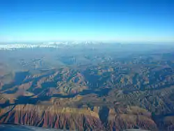 Aerial View East-Northeast of Garmsar | |
 Garmsar | |
| Coordinates: 35°13′06″N 52°20′27″E | |
| Country | |
| Province | Semnan |
| County | Garmsar |
| Bakhsh | Central |
| Population (2016 Census) | |
| • Total | 48,672 [1] |
| Time zone | UTC+3:30 (IRST) |
| • Summer (DST) | UTC+4:30 (IRDT) |
Garmsar is located about 95 kilometres (59 mi) southeast of Tehran. It lies on the edge of Dasht-e Kavir, Iran's largest desert. Many people in the city commute to Tehran due to its proximity. Ghasre Bahram, The Stone Way, Stonvand Castle, the Sar Darre Mountains, and Kavir Desert National Park are tourist attractions located in the area.
People
Garmsar has a Persian majority. Persian and Tati are the main languages in Garmsar County. Other languages such as Azeri and Kurdish are still spoken by older people from different ethnicities like Osanlu and Pazuki in the nearby villages. Younger generation speaks Persian and those languages are being forgotten by time.
Notable people
- Amir Arsalan Motahari
- Jalil Zandi
- Ali Sorena
Agricultural sector
The Hablehrood river originating from Dalichai-Firouzkooh flows to the plateau of Garmsar. Its water is extensively used for agriculture. Since salt water mixes with Hablehrood before its arrival to the city, the water is not fit for drinking. Hablehrood is the only permanent river in Semnan province. Thanks to the water provided by Hablehrood, people in Garmsar grow wheat, barley, cotton and yellow melon. Garmsar is known across Iran for its sweet and crispy yellow melons.[3]
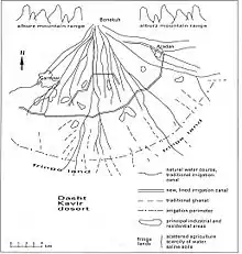
Water management
The many river branches and the irrigated fields provide recharge to the aquifer. Since ancient times, groundwater in the Garmsar area has been exploited by ghanats (qanats, karezes) and shallow wells, mainly for irrigation of agricultural land, but also for household purposes. In the last decades, the number of deep-wells has increased sharply and the ghanats have fallen dry.[4]
Yet, at the fringes of the fan, problems of waterlogging occur owing to irrigation losses higher up that are transported through the aquifer to the lower lying areas causing shallow watertables, while the evaporation from the shallow watertable brings salts into the rootzone which henceforth is salinizing. As a result, the agriculture in the fringes suffers low yields or is impossible.
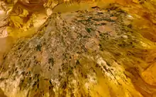
 | Simulation of soil salinity (left) and depth of the watertable (right) in the Garmsar alluvial fan using the spatial agro-hydro-salinity model SahysMod[5] | 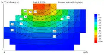 |
Cuisine
The traditional cuisine of the city is called Tahchin. It differs from the classic Tahchin common in other cities. Tahchin is a tasty and fragrant rice-based food where marinated raw meat is slowly cooked inside the rice over a low flame for several hours.[3]
Education
- Adiban Institute of Higher Education
- Alla ed Dolle Haji Abad, Garmsar
- Amirkabir University of Technology - Garmsar Branch
- Elmi Kaar Bordi, Garmsar
- Islamic Azad University of Garmsar[6]
- Payame Noor University
- University of Garmasar[7]
References
- https://www.amar.org.ir/english
- "Census of the Islamic Republic of Iran, 1385 (2006)". Islamic Republic of Iran. Archived from the original (Excel) on 2011-11-11.
- http://www.garmsarnews.com/ashpazi/ashpazi00.htm
- "Irrigation in the alluvial fan of Garmsar, Iran" (PDF). International Institute for Land Reclamation and Improvement. 2000.
- "Spatial agro-hydro-salinity model". International Institute for Land Reclamation and Improvement. 1998.
- "Archived copy". Archived from the original on 2019-10-16. Retrieved 2006-09-03.CS1 maint: archived copy as title (link)
- http://www.ugsr.ir
External links
![]() Media related to Garmsar at Wikimedia Commons
Media related to Garmsar at Wikimedia Commons
| Capital | 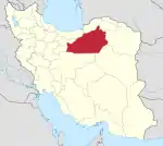 | ||||||||||||||||
|---|---|---|---|---|---|---|---|---|---|---|---|---|---|---|---|---|---|
| Counties and cities |
| ||||||||||||||||
| Sights |
| ||||||||||||||||
| populated places | |||||||||||||||||
