Geo-Wiki
Geo-Wiki is a platform for engaging citizens and experts in both biophysical and socioeconomic monitoring, established in 2009 at the International Institute for Applied Systems Analysis (IIASA). It aids in both, the validation of existing geographical information and the collection of new geographical information through crowdsourcing [1][2] and citizen science.[3] Using tools such as Google satellite imagery, Bing Maps, Geotagged photographs and the Internet, individual volunteers are able to contribute valuable in-situ data on land cover and land use, either by validating existing data in comparing it with satellite imagery (through visual interpretation), or by collecting new. Except on the conventional way, other method for crowd-sourced data collection in Geo-Wiki is through campaigns and games, used as incentives to motivate citizens. Collected data in the platform is freely available.
A crowd-sourced tool for land cover/land use validation through visual interpretation | |
Type of site | Scientific |
|---|---|
| Available in | English |
| Founded | 2009 |
| Country of origin | Austria |
| Created by | International Institute for Applied Systems Analysis |
| Industry | Citizen Science |
| URL | https://www.geo-wiki.org |
| Commercial | No |
Geo-Wiki already has more than 15 000 registered contributors, and many successful citizen science campaigns, collecting data on topics such as global built-up surface validation, human impact on forests,[4] global agricultural field-size data[5] and more.
Land cover validation
Global land cover validation exercises are feasible as images less than 2.5 meter resolution provide very detailed information on land cover with global coverage of at least 20%[6] with more high-resolution, up to date images continuously being added. Internet tools such as Google Earth offer enormous potential for land cover validation.[7] The use of Volunteer Geographic Information for land cover validation studies seems even more relevant as Google Earth has been used for the recent validation of remote sensing derived products e.g., the European forest cover map[8] as well as the latest global land cover map GlobCover.[9] Google Earth allows wider audience to be involved in a validation exercise.
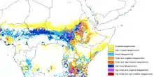
Applications of Geo-Wiki go beyond simply improving land cover. An application helps to predict future deforestation in Central Africa,[10] combining five existing cropland data sets from sub-Saharan Africa to create a new map which has higher accuracy than existing maps. This should reduce uncertainty and improve predictions in land use, vegetation, climate change, and earth systems modeling. Scientists from several research institutions describe development of the map in Geophysical Research Letters, along with the application of Geo-Wiki.[11]
Gamification
The Geo-Wiki ecosystem comprises a number of applications, some of which use gamification mechanisms to attract and motivate citizen scientists and experts to participate in campaigns and make valuable contributions to science. Some of these apps are:
References
- "Remote Sensing | Free Full-Text | Geo-Wiki.Org: The Use of Crowdsourcing to Improve Global Land Cover". Mdpi.com. doi:10.3390/rs1030345. Retrieved 2012-01-06. Cite journal requires
|journal=(help) - See, L., Mooney, P., Foody, G., Bastin, L., Comber, A., Estima, J., Fritz, S., Kerle, N., Jiang, B., Laakso, M., Liu, H.-Y., Milcinski, G., Niksic, M., Painho, M., Podör, A., Olteanu-Raimond, A.-M. and Rutzinger, M. (2016) Crowdsourcing, Citizen Science or Volunteered Geographic Information? The Current State of Crowdsourced Geographic Information. ISPRS International Journal of Geo-Information, 5 (5). p. 55.
- Vohland, Katrin; Land-zandstra, Anne; Ceccaroni, Luigi; Lemmens, Rob; Perelló, Josep; Ponti, Marisa; Samson, Roeland; Wagenknecht, Katherin, eds. (2021). The Science of Citizen Science. Springer International Publishing. ISBN 978-3-030-58277-7.
- "New Citizen Science Campaign on Human Impact on Forests - 2019 - IIASA". iiasa.ac.at. Retrieved 2020-11-05.
- "Crowdsourced field data shows importance of smallholder farms to global food production - 2018 - IIASA". iiasa.ac.at. Retrieved 2020-11-05.
- Potere, D. Horizontal positional accuracy of google earth's high-resolution imagery archive.Sensors 2008, 8, 7973-7981
- Butler, D. The web-wide world. Nature 2006, 439, 776-778
- Pekkarinen, A.; Reithmaier, L.; Strobl, P. Pan-European forest/non-forest mapping with Landsat ETM+ and CORINE Land Cover 2000 data. ISPRS J. Photogramm. 2009, 64, 171-183
- Defourny, P.P.; Schouten, L.; Bartalev, S.; Bontemps, S.P.; Caccetta, P. et al., Accuracy Assessment of a 300 m Global Land Cover Map: The GlobCover Experience, 2009
- Anjali Nayar (2009-11-20). "Model predicts future deforestation : Nature News". Nature. Nature.com. doi:10.1038/news.2009.1100. Retrieved 2012-01-06.
- "Cropland for sub-Saharan Africa: A synergistic approach using five land cover data sets". Agu.org. Retrieved 2012-01-06.