Geography of Martinique
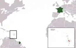
Martinique is an island located at the geographic center of the Lesser Antilles chain in the Caribbean Sea, southeast of Cuba and north of Trinidad and Tobago. It is part of the French West Indies.
| Nickname: Island of Flowers | |
|---|---|
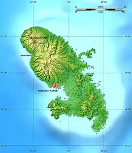 Map of Martinique | |
 | |
| Geography | |
| Location | Caribbean Sea |
| Coordinates | 14°40′N 61°00′W |
| Archipelago | Windward Islands |
| Area | 1,060 km2 (410 sq mi) |
| Coastline | 350 km (217 mi) |
| Highest elevation | 1,397 m (4583 ft) |
| Highest point | Montagne Pelee |
| Administration | |
France | |
| Overseas department | Martinique |
| Largest settlement | Fort-de-France (pop. 81,006) |
| Demographics | |
| Population | 372,594 (2020) |
| Pop. density | 405.2/km2 (1049.5/sq mi) |
| Ethnic groups | African and African-white-Indian mixture 90%, white 5%, Indian Tamil or East Indian, Chinese less than 5% |
Statistics
Area:
total:
1,100 km²
land:
1,060 km²
water:
40 km²
Area - comparative: slightly more than two times the size of the isle of Man, or six times the size of the City of Washington, D.C.
Land boundaries: 0 km
Maritime claims:
exclusive economic zone:
200 nmi (370.4 km; 230.2 mi)
territorial sea:
12 nmi (22.2 km; 13.8 mi)
Climate: tropical; moderated by trade winds; rainy season (June to December); vulnerable to devastating hurricanes every eight years on average; average temperature 26.3 degrees Celsius; humid
Natural resources: coastal scenery and beaches, cultivable land
Land use:
arable land:
8%
permanent crops:
8%
permanent pastures:
17%
forests and woodland:
44%
other:
23% (1993 est.)
Irrigated land: 40 km² (1993 est.)
Natural hazards: hurricanes, flooding, and volcanic activity (an average of one major natural disaster every five years)
Extreme points
- Northernmost point - Cap Saint Martin
- Easternmost point - Cap Ferré
- Southernmost point - Ilet Cabrits
- Westernmost point - unnamed headland near Anse Belleville
- Highest point - Mont Pelee 1,397 m
- Lowest point - Caribbean Sea 0 m
Terrain
Martinique can be separated by the north, central, and southern portions of the island. The mountainous, sparsely populated north, covered with dense rainsforests, contains 4 main active or extinct volcanic ranges towering around 1000 meters above sea level - Pitons du Carbet, Morne Jacob, Mount Pelee and Piton Conil. Black sand beaches predominate in northern Martinique due to volcanism.
The more populated, field covered Southern part of Martinique is occupied by lower altitudes ridges and hills, towering around 400-500 lmeters above sea level, with a rugged coast line including numerous white sand corallian coves. The deeply populated central part of the island, home of the vast majority of the population, and formed by the lower slopes of the Pitons du Carbet massif and the Lamentin and Rivière Salée plains, covered with sugarcanes and mangroves, is a transition zone between the mountainous north and the hilly south. [1]
Martinique is surrounded by small islets and hosts three main peninsulas, the Presqu'ile de la Caravelle Peninsula in the Atlantic coast, the Trois Ilets Peninsula in the Southwest Caribbean coast and the Saint Anne Peninsula in the Saint Lucia Channel.
See also
References
![]() This article incorporates public domain material from the CIA World Factbook website https://www.cia.gov/the-world-factbook/.
This article incorporates public domain material from the CIA World Factbook website https://www.cia.gov/the-world-factbook/.
- "Geography of Martinique, Caribbean island - MartinicaOnline". martinicaonline.com. Retrieved 2019-05-20.
External links
| Sovereign states |  | |
|---|---|---|
Dependencies and other territories | ||
| Wikimedia Commons has media related to Geography of Martinique. |