Geologic province
A geologic province is a spatial entity with common geologic attributes.[1] A province may include a single dominant structural element such as a basin or a fold belt, or a number of contiguous related elements. Adjoining provinces may be similar in structure but be considered separate due to differing histories.
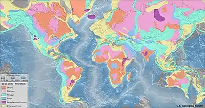
Geologic provinces by origin
| Province | Definition | Subcategories | Examples |
|---|---|---|---|
| Shield | Exposed Precambrian crystalline igneous and metamorphic rocks that form tectonically stable areas | ||
| Platform | Horizontal or gently-lying sedimentary strata covering a basement of igneous or metamorphic rocks | ||
| Orogen | Linear or arc-shaped formation where continental crust has been folded, deformed and uplifted to form mountain ranges | ||
| Basin | Low-lying formation of rock strata formed by tectonic warping of previously horizontal strata | ||
| Large igneous province | Accumulation of igneous rocks, including liquid rock (intrusive) or volcanic rock formations (extrusive) | ||
| Extended crust | Continental crust thinned due to extensional strain |
Geologic provinces by resources
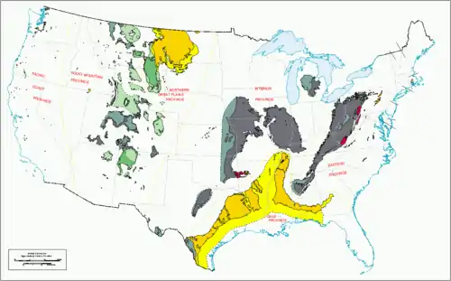
US coal regions and provinces.
Some studies classify provinces based upon mineral resources, such as mineral deposits. There are a particularly large number of provinces identified worldwide for petroleum and other mineral fuels, such as the Niger Delta petroleum province.
References
- "Geologic Province and Thermo-Tectonic Age Maps". Earthquake Hazards Program. United States Geological Survey. Archived from the original on 7 June 2014. Retrieved 6 June 2014.
- "Geologic Provinces of the United States: Records of an Active Earth". United States Geological Survey. Archived from the original on 7 June 2014. Retrieved 6 June 2014.
External links
This article is issued from Wikipedia. The text is licensed under Creative Commons - Attribution - Sharealike. Additional terms may apply for the media files.