Georgetown, Quitman County, Georgia
Georgetown is a city in Quitman County, Georgia, United States. It is on the Alabama-Georgia state line next to Walter F. George Lake and across the Chattahoochee River from Eufaula, Alabama. The population was 2,513 at the 2010 census. In 2006, Georgetown and Quitman County voted to consolidate their governments, becoming the smallest such consolidated entity in the Lower 48 states.[1]
Georgetown, Georgia | |
|---|---|
city | |
 Georgetown in 2012. | |
 Location in Quitman County and the state of Georgia | |
| Coordinates: 31°53′02″N 85°06′05″W | |
| Country | United States |
| State | Georgia |
| Counties | Quitman |
| Area | |
| • Total | 3.9 sq mi (10.2 km2) |
| • Land | 2.7 sq mi (7.1 km2) |
| • Water | 1.2 sq mi (3.1 km2) |
| Population (2010) | |
| • Total | 2,513 |
| • Density | 249.5/sq mi (95.4/km2) |
| ZIP code s | 31754, 39854 |
| Area code(s) | 229 |
History
Settled in the early 1830s, Georgetown was first named Tobanana for the nearby creek. The Tobanana Post Office was established on January 10, 1833. On September 21, 1836, the name of the town was changed to "Georgetown" after the historic neighborhood in Washington, D.C.[2]
Georgetown was designated in 1859 as the county seat of Quitman County and was laid out as a town by order of the Inferior Court. The town was incorporated by an act of the legislature on December 9, 1859.
A brigade of federal cavalry, commanded by General Benjamin H. Grierson, camped for a time near Georgetown on the banks of the Tobanana Creek at the close of the American Civil War.
Georgetown was destroyed by fire in 1903; every building except for the post office and three houses were destroyed.
The only county in Georgia in the 70's and 80's where a woman was employed as a ranger by the Georgia Forest commission. Carolyn Sanders Davis retired in 1989 and was the last person to man the tower, covering several counties.
Geography
According to the United States Census Bureau, the city has a total area of 3.9 square miles (10 km2), of which 2.7 square miles (7.0 km2) is land and 1.2 square miles (3.1 km2) (30.46%) is water.
Demographics
| Historical population | |||
|---|---|---|---|
| Census | Pop. | %± | |
| 1870 | 263 | — | |
| 1880 | 245 | −6.8% | |
| 1890 | 348 | 42.0% | |
| 1900 | 348 | 0.0% | |
| 1910 | 313 | −10.1% | |
| 1920 | 244 | −22.0% | |
| 1930 | 345 | 41.4% | |
| 1940 | 367 | 6.4% | |
| 1950 | 550 | 49.9% | |
| 1960 | 554 | 0.7% | |
| 1970 | 860 | 55.2% | |
| 1980 | 935 | 8.7% | |
| 1990 | 913 | −2.4% | |
| 2000 | 973 | 6.6% | |
| 2010 | 2,513 | 158.3% | |
| 2018 (est.) | 2,279 | [3] | −9.3% |
| U.S. Decennial Census[4] | |||
As of the census[5] of 2000, there were 973 people, 367 households, and 274 families residing in the city. The population density was 355.0 people per square mile (137.1/km2). There were 554 housing units at an average density of 202.1 per square mile (78.1/km2). The racial makeup of the city was 60.02% African American, 39.77% White, 0.10% Asian, and 0.10% from two or more races.
There were 367 households, out of which 29.4% had children under the age of 18 living with them, 44.4% were married couples living together, 26.2% had a female householder with no husband present, and 25.3% were non-families. 22.6% of all households were made up of individuals, and 13.6% had someone living alone who was 65 years of age or older. The average household size was 2.65 and the average family size was 3.11.
In the city, the population was spread out, with 27.6% under the age of 18, 7.0% from 18 to 24, 25.2% from 25 to 44, 20.1% from 45 to 64, and 20.0% who were 65 years of age or older. The median age was 38 years. For every 100 females, there were 83.2 males. For every 100 females age 18 and over, there were 75.1 males.
The median income for a household in the city was $22,941, and the median income for a family was $25,250. Males had a median income of $22,404 versus $20,000 for females. The per capita income for the city was $11,407. About 22.0% of families and 25.9% of the population were below the poverty line, including 25.9% of those under age 18 and 30.4% of those age 65 or over.
Education
Quitman County School District
The Quitman County School District holds grades pre-school to grade eight, and consists of one elementary-middle school, and one high school that consists of grades ninth through twelfth.[6] The district has 22 full-time teachers and over 314 students.[7]
Gallery
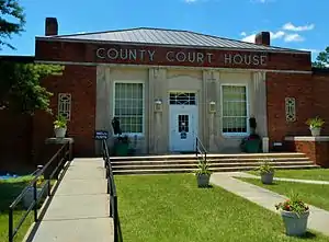 Quitman County Courthouse was built in 1939 by the Public Works Administration using federal relief funds. It was added to the National Register of Historic Places.
.JPG.webp) The old Quitman County Jail. It was added to the National Register of Historic Places.
The old Quitman County Jail. It was added to the National Register of Historic Places.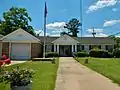 Georgetown City Hall.
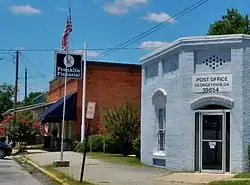
.JPG.webp) Georgetown Post Office (ZIP code: 39854)
Georgetown Post Office (ZIP code: 39854)
References
- "New Georgetown-Quitman County Government Sets Consolidation Record". Carl Vinson Institute of Government, University of Georgia. Retrieved 20 June 2015.
- Krakow, Kenneth K. (1975). Georgia Place-Names: Their History and Origins (PDF). Macon, GA: Winship Press. p. 92. ISBN 0-915430-00-2.
- "Population and Housing Unit Estimates". Retrieved December 12, 2019.
- "Census of Population and Housing". Census.gov. Retrieved June 4, 2015.
- "U.S. Census website". United States Census Bureau. Retrieved 2008-01-31.
- Georgia Board of Education, Retrieved June 25, 2010.
- School Stats, Retrieved June 25, 2010.
External links
Municipalities and communities of Quitman County, Georgia, United States | ||
|---|---|---|
| City | 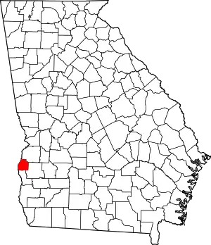 Map of Georgia highlighting Quitman County | |
| Unincorporated communities | ||
| ||