Germagny
Germagny is a commune in the Saône-et-Loire department in the region of Bourgogne-Franche-Comté in eastern France.
Germagny | |
|---|---|
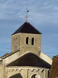 The Romanesque Church | |
Location of Germagny 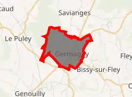
| |
 Germagny  Germagny | |
| Coordinates: 46°40′15″N 4°36′11″E | |
| Country | France |
| Region | Bourgogne-Franche-Comté |
| Department | Saône-et-Loire |
| Arrondissement | Chalon-sur-Saône |
| Canton | Givry |
| Intercommunality | Sud de la Côte chalonnaise |
| Government | |
| • Mayor (2008–2014) | Pierre Dubois |
| Area 1 | 3.47 km2 (1.34 sq mi) |
| Population (2017-01-01)[1] | 202 |
| • Density | 58/km2 (150/sq mi) |
| Time zone | UTC+01:00 (CET) |
| • Summer (DST) | UTC+02:00 (CEST) |
| INSEE/Postal code | 71216 /71460 |
| Elevation | 245–358 m (804–1,175 ft) (avg. 300 m or 980 ft) |
| 1 French Land Register data, which excludes lakes, ponds, glaciers > 1 km2 (0.386 sq mi or 247 acres) and river estuaries. | |
Geography
The village is located on the Guye river valley. The main roads connect the village to Savianges and Fley to the north, Bissy-sur-Fley to the east, Genouilly to the south and le Puley to the west.
Main sights
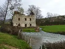
An old mill near the River Guye in Germagny
- The Romanesque church, where a fresco showing a teenage Christ in glory, was discovered in 1983 in the apse.[2]
- The public footpath near the River Guye. It was named "La Pléiade", in memory of Pontus de Tyard and Guillaume des Autels, who used to live in the neighbouring villages.[3]
References
- "Populations légales 2017". INSEE. Retrieved 6 January 2020.
- "Fiche_GERMAGNY" (PDF) (in French). pastourisme71. Retrieved 2 January 2013.
- (in French) J.-Pierre Valabregue, Guillaume des Autelz, gentilhomme charolais (1529 – 1581). Un cousin poète méconnu., le journal de Saône-et-Loire du 29/01/2011
| Wikimedia Commons has media related to Germagny. |
| Authority control |
|---|
This article is issued from Wikipedia. The text is licensed under Creative Commons - Attribution - Sharealike. Additional terms may apply for the media files.