Giessenlanden
Giessenlanden (Dutch: [ˈɣisə(n)ˌlɑndə(n)] (![]() listen)) is a former municipality in the western Netherlands, in the province of South Holland. The municipality covered an area of 65.11 km2 (25.14 sq mi) of which 1.54 km2 (0.59 sq mi) is water, and had a population of as of 2019. The municipality included communities of Arkel, Giessen-Oudekerk, Giessenburg, Hoogblokland, Hoornaar, Noordeloos and Schelluinen.
listen)) is a former municipality in the western Netherlands, in the province of South Holland. The municipality covered an area of 65.11 km2 (25.14 sq mi) of which 1.54 km2 (0.59 sq mi) is water, and had a population of as of 2019. The municipality included communities of Arkel, Giessen-Oudekerk, Giessenburg, Hoogblokland, Hoornaar, Noordeloos and Schelluinen.
Giessenlanden | |
|---|---|
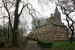 Castle in Schelluinen | |
 Flag  Coat of arms | |
.svg.png.webp) Location in South Holland | |
| Coordinates: 51°53′N 4°57′E | |
| Country | Netherlands |
| Province | South Holland |
| Municipality | Molenlanden |
| Established | 1 January 1986 |
| Merged | 2019 |
| Area | |
| • Total | 65.11 km2 (25.14 sq mi) |
| • Land | 63.57 km2 (24.54 sq mi) |
| • Water | 1.54 km2 (0.59 sq mi) |
| Elevation | −1 m (−3 ft) |
| Time zone | UTC+1 (CET) |
| • Summer (DST) | UTC+2 (CEST) |
| Postcode | 3380–3381, 4209, 4220–4225, 4240–4241 |
| Area code | 0183, 0184 |
| Website | www |
On 1 January 2019, it merged with Molenwaard to form the new municipality of Molenlanden.[3]
Topography

Dutch topographic map of the municipality of Giessenlanden, June 2015
Public transportation
The Arkel railway station, on the Elst–Dordrecht railway, is situated in the municipality Giessenlanden.
References
- "Kerncijfers wijken en buurten 2020" [Key figures for neighbourhoods 2020]. StatLine (in Dutch). CBS. 24 July 2020. Retrieved 19 September 2020.
- "Postcodetool for 4223ME". Actueel Hoogtebestand Nederland (in Dutch). Het Waterschapshuis. Archived from the original on 21 September 2013. Retrieved 19 July 2013.
- "Herindeling Molenwaard-Giessenlanden". Retrieved 3 January 2019.
External links
Places adjacent to Giessenlanden | ||||||||||
|---|---|---|---|---|---|---|---|---|---|---|
| ||||||||||
This article is issued from Wikipedia. The text is licensed under Creative Commons - Attribution - Sharealike. Additional terms may apply for the media files.