Gelderland
Gelderland (/ˈɡɛldərlænd/, also US: /-lɑːnt/,[4][5][6] Dutch: [ˈɣɛldərlɑnt] (![]() listen)), also known as Guelders (/ˈɡɛldərz/)[7] in English, is a province of the Netherlands, occupying the centre-east of the country. With a total area of 5,136 km2 (1,983 sq mi) of which 173 km2 (67 sq mi) is water, it is the largest province of the Netherlands.[8] Gelderland shares borders with six other provinces (Flevoland, Limburg, North Brabant, Overijssel, South Holland and Utrecht) and the German state of North Rhine-Westphalia.
listen)), also known as Guelders (/ˈɡɛldərz/)[7] in English, is a province of the Netherlands, occupying the centre-east of the country. With a total area of 5,136 km2 (1,983 sq mi) of which 173 km2 (67 sq mi) is water, it is the largest province of the Netherlands.[8] Gelderland shares borders with six other provinces (Flevoland, Limburg, North Brabant, Overijssel, South Holland and Utrecht) and the German state of North Rhine-Westphalia.
Gelderland | |
|---|---|
 Coat of arms | |
| Anthem: "Ons Gelderland" "Our Gelderland" | |
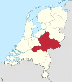 Location of Gelderland in the Netherlands | |
| Coordinates: 52.06°N 5.95°E | |
| Country | Netherlands |
| Capital | Arnhem |
| Largest city | Nijmegen |
| Government | |
| • King's Commissioner | John Berends (CDA) |
| Area (2017)[1] | |
| • Total | 5,136 km2 (1,983 sq mi) |
| • Land | 4,964 km2 (1,917 sq mi) |
| • Water | 173 km2 (67 sq mi) |
| Area rank | 2nd |
| Population (1 November 2019)[2] | |
| • Total | 2,084,478 |
| • Rank | 4th |
| • Density | 420/km2 (1,100/sq mi) |
| • Density rank | 6th |
| ISO 3166 code | NL-GE |
| Religion (1999) | 31% Protestant, 29% Catholic |
| HDI (2018) | 0.922[3] very high · 6th |
| Website | www.gelderland.nl |
The capital is Arnhem (pop. 159,265[9]); however, Nijmegen (pop. 176,731) and Apeldoorn (pop. 162,445) are both larger municipalities. Other major regional centres in Gelderland are Ede, Doetinchem, Zutphen, Harderwijk, Tiel, Wageningen, Zevenaar, and Winterswijk. Gelderland had a population of 2,084,478 as of November 2019.[2]
History
Historically, the province dates from states of the Holy Roman Empire and takes its name from the nearby German city of Geldern. According to the Wichard saga, the city was named by the Lords of Pont who fought and killed a dragon in 878 AD. They named the town they founded after the death rattle of the dragon: "Gelre!"[10]
The County of Guelders arose out of the Frankish pagus Hamaland in the 11th century around castles near Roermond and Geldern. The counts of Gelre acquired the Betuwe and Veluwe regions and, through marriage, the County of Zutphen. Thus the counts of Guelders laid the foundation for a territorial power that, through control of the Rhine, Waal, Meuse and IJssel rivers, was to play an important role in the later Middle Ages. The geographical position of their territory dictated the external policy of the counts during the following centuries; they were committed to the interests of the Holy Roman Empire and to expansion south and west.
Further enlarged by the acquisition of the imperial city of Nijmegen in the 13th century, the countship was raised to a duchy in 1339 by the Holy Roman Emperor, Louis IV. After 1379, the duchy was ruled from Jülich and by the counts of Egmond and Cleves. The duchy resisted Burgundian domination, but William, Duke of Jülich-Cleves-Berg was forced to cede it to Charles V in 1543, after which it formed part of the Burgundian-Habsburg hereditary lands.[11]
The duchy revolted with the rest of the Netherlands against Philip II of Spain and joined the Union of Utrecht (1579). After the deposition of Philip II, its sovereignty was vested in the States of Gelderland, and the princes of Orange were stadtholders. In 1672, the province was temporarily occupied by Louis XIV and, in 1713, the southeastern part including the ducal capital of Geldern fell to Prussia. Part of the Batavian Republic (1795–1806), of Louis Bonaparte’s Kingdom of Holland (1806–10), and of the French Empire (1810–13), Gelderland became a province of the Kingdom of the Netherlands in 1815.[11]
During the Second World War, it saw heavy fighting between Allied Paratroopers, British XXX Corps and the German II SS Panzer Corps, at the Battle of Arnhem.
Culture
In Gelderland there are many museums, like the Netherlands Open Air Museum and Museum Arnhem in Arnhem, Valkhof Museum in Nijmegen, the Het Loo Palace in Apeldoorn and in Otterlo the Kröller-Müller Museum. Some cities are also equipped with large theaters like the Musis sacrum in Arnhem, Concertgebouw de Vereeniging and Orpheus (Theater) in Apeldoorn. The known by a larger public music venues are the Luxor Live and Doornroosje, and the GelreDome in Arnhem. these venues offer concerts from popular artist. every year the municipality Renkum and Overbetuwe receive a large amount of tourist visiting because of the Battle of Arnhem. Often historical locations are visited, like the John Frost Bridge and the Arnhem Oosterbeek War Cemetery in Oosterbeek.
Geography
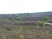
Gelderland can roughly be divided into four geographical regions: the Veluwe in the north, the Rivierenland including the Betuwe in the southwest, the Achterhoek (literally meaning the "back corner") or Graafschap (which originally means earldom or county) in the east and the city-region of Arnhem and Nijmegen in the centre-south.
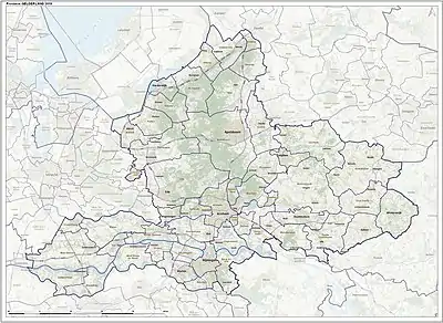
Municipalities
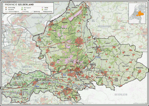
In 2020, the 51 municipalities in Gelderland were divided into four COROPs:
- Veluwe COROP group
- South West Gelderland COROP group
- Achterhoek COROP group
- Arnhem & Nijmegen COROP group
Abolished municipalities
.jpg.webp)
These municipalities were merged with neighbouring ones:
- Angerlo was merged into Zevenaar
- Dinxperlo was merged into Aalten
- Gorssel was merged into Lochem
- Hoevelaken was merged into Nijkerk
- Lichtenvoorde was merged into Groenlo (renamed Oost Gelre in 2006)
- Millingen aan de Rijn and Ubbergen were merged into Groesbeek (renamed Berg en Dal in 2016)
- Rijnwaarden was merged into Zevenaar
- Warnsveld was merged into Zutphen
- Wehl was merged into Doetinchem
These municipalities were merged and given a new name:
- Bergh and Didam have become Montferland
- Borculo, Eibergen, Neede and Ruurlo have become Berkelland
- Geldermalsen, Lingewaal and Neerijnen have become West Betuwe
- Gendringen and Wisch have become Oude IJsselstreek
- Hengelo, Hummelo en Keppel, Steenderen, Vorden and Zelhem have become Bronckhorst
Economy
The gross domestic product (GDP) of the region was €78.3 billion in 2018, accounting for 10.1% of the Netherlands' economic output. GDP per capita adjusted for purchasing power was €33,000 or 110% of the EU27 average in the same year.[12]
Cultural references
In the 2001 movie A Knight's Tale, the protagonist, William Thatcher (played by Heath Ledger) pretends to be a knight known as "Ulrich von Lichtenstein from Gelderland".
References
- "Oppervlakte".
- "CBS Statline". opendata.cbs.nl.
- "Sub-national HDI - Area Database - Global Data Lab". hdi.globaldatalab.org. Retrieved 13 September 2018.
- "Gelderland". The American Heritage Dictionary of the English Language (5th ed.). Boston: Houghton Mifflin Harcourt. Retrieved 1 May 2019.
- "Gelderland" (US) and "Gelderland". Oxford Dictionaries UK Dictionary. Oxford University Press. Retrieved 1 May 2019.
- "Gelderland". Merriam-Webster Dictionary. Retrieved 1 May 2019.
- "Guelders". Collins English Dictionary. HarperCollins. Retrieved 1 May 2019.
- "Regionale kerncijfers Nederland" [Regional key figures Netherlands]. CBS Statline (in Dutch). CBS. 17 June 2020. Retrieved 21 June 2020.
- "CBS Statline". opendata.cbs.nl.
- Geldersche volksalmanak Volumes 21-22; Nijhoff & son; 1855
- "Gelderland". Britannica.com. Retrieved 13 July 2015.
- "Regional GDP per capita ranged from 30% to 263% of the EU average in 2018". Eurostat.
External links
| Wikimedia Commons has media related to Gelderland. |
| Wikivoyage has a travel guide for Gelderland. |

| ||
 | ||
| Authority control |
|---|