Gimry
Gimry (Russian: Гимры) is a rural locality (a selo) in Untsukulsky District of the Republic of Dagestan, Russia, located in the mountain where Imam Shamil, the third Imam of Dagestan, was born. Population: 4,654 (2010 Census);[1] 3,362 (2002 Census).[4]
Gimry
Гимры | |
|---|---|
| Other transcription(s) | |
| • Avar | Генуб |
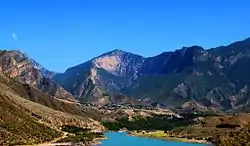
 View of Gimry | |
 Coat of arms | |
Location of Gimry 
| |
 Gimry Location of Gimry  Gimry Gimry (Republic of Dagestan) | |
| Coordinates: 42°45′26″N 46°50′44″E | |
| Country | Russia |
| Federal subject | Dagestan |
| Administrative district | Untsukulsky District |
| Population | |
| • Total | 4,654 |
| Time zone | UTC+3 (MSK |
| Postal code(s)[3] | 368951 |
| Dialing code(s) | +7 87257 |
| OKTMO ID | 82653420101 |

Geography
Gimry is located on the east bank of the north-flowing Avar Koysu river at the bottom of a 5000-foot deep canyon. On the east side the upper 1500 feet are nearly vertical. It is at the mouth of a side canyon that extends about 7 kilometers southeast. In the nineteenth century the only approaches from the east were from the village of Karanai and along the sides of the Sulak and Avar Koysu canyons or by a path down to the side canyon where the Gimry tunnel is now. Four kilometers north the Avar Koysu joins the east-flowing Andi Koysu to form the Sulak River. To the south on the Avar Koysu is the village of Untsokul, the Irganay dam and the villages of Irganay and Zirani. West on the Andi Koysu are the rock fortress of Akhulgo and the villages of Ashitla and Igali.
History
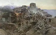
Gimry was part of a group of villages called or Koysubu or Hindal. It was a center of resistance to Russia during the Murid War (1829-1859). Both Kazi Mulla and Imam Shamil were born here in the 1790s. In 1830, Baron Rosen tried to attack it and gave up. In 1832, Kazi Mulla died here during the Battle of Gimry. In 1834, Lanskoy attacked it. In 1837, the Russians were defeated just to the north at the battle of the Ashitla bridge. Later in the same year the village of Ashitla to the west was destroyed. In 1839 it was neutral during the Siege of Akhoulgo. In 1840, Klugenau attacked it. After 1840, the center of resistance moved northwest to the forests of Chechnya. During the Dagestan Uprising (1920) ninety percent of the buildings were destroyed by artillery. Its surrender in late February 1921 was almost the end of the uprising.
Recent events
In 2014 Russian soldiers again besieged Gimry, while trying to capture Gimry native Magomed Suleymanov, who had been proclaimed emir of the Caucasus Emirate. Gimry remained blocked by Russian troops to all except its residents for a while.[5] As of October 2015, each resident had to give a 5-digit number to enter or leave town, while all others had to register and foreigners were not permitted.[6]
See also
References
- Russian Federal State Statistics Service (2011). "Всероссийская перепись населения 2010 года. Том 1" [2010 All-Russian Population Census, vol. 1]. Всероссийская перепись населения 2010 года [2010 All-Russia Population Census] (in Russian). Federal State Statistics Service.
- "Об исчислении времени". Официальный интернет-портал правовой информации (in Russian). 3 June 2011. Retrieved 19 January 2019.
- Почта России. Информационно-вычислительный центр ОАСУ РПО. (Russian Post). Поиск объектов почтовой связи (Postal Objects Search) (in Russian)
- Russian Federal State Statistics Service (21 May 2004). "Численность населения России, субъектов Российской Федерации в составе федеральных округов, районов, городских поселений, сельских населённых пунктов – районных центров и сельских населённых пунктов с населением 3 тысячи и более человек" [Population of Russia, Its Federal Districts, Federal Subjects, Districts, Urban Localities, Rural Localities—Administrative Centers, and Rural Localities with Population of Over 3,000] (XLS). Всероссийская перепись населения 2002 года [All-Russia Population Census of 2002] (in Russian).
- "Russia and Islamic State: Caucasian jihad". The Economist. 4 July 2015. Retrieved 5 July 2015.
- Washington Post, 28oct15, page A1, 'The other Russian supply line'
