Glenbeigh
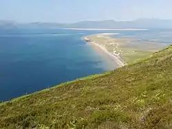
Glenbeigh or Glanbehy (Irish: Gleann Beithe) is a town and civil parish in County Kerry, southwestern Ireland. The area is on the Iveragh peninsula, the largest peninsula in southwestern Ireland. The parish is home to Rossbeigh Beach, Coomasahran Lake, a number of rock art sites, the natterjack toad and the Kerry bog pony. Owing to its natural heritage, history and its location on the Ring of Kerry, Glenbeigh is a tourist destination.
Glenbeigh
Gleann Beithe | |
|---|---|
Town | |
 Rossbeigh Beach Glenbeigh | |
 Glenbeigh Location in Ireland | |
| Coordinates: 52.058056°N 9.937778°W | |
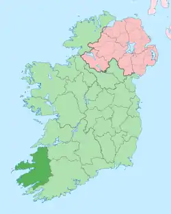
| Country | Ireland |
| Province | Munster |
| County | County Kerry |
| Elevation | 50 m (160 ft) |
| Population (2016)[1] | |
| • Total | 308 |
| Website | www |
Glenbeigh is surrounded by a horseshoe of hills and the Seefin Mountains. The Caragh and Behy rivers flow at either side of the village into Castlemaine Harbour.[2]
Name
The Irish name Gleann Beithe is from gleann "glen, valley" and Beithe, related to the Behy River (Irish An Bheithe[3]) and the birch tree (beith).[3][4] The anglicisation "Glanbehy" is the official spelling for the civil parish,[5] whereas Glenbeigh is the spelling for the village where the N70 road meets the Behy River.[4]
History
A number of Fianna legends centre around Glenbeigh. These legends suggest that Diarmuid and Grainne spent some days hiding in a cave in the valley of the Behy. Nearby Rossbeigh is known for being the place where Oisin and Niamh took to the sea on their white horse to live in Tír na nÓg (the land of youth).
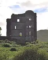
Near the village is the ruin of "Wynne's Folly" or "Glenbeigh Towers".[6] This mansion was built by Lord Headley Wynne in 1867. The barbarity and brutality of Mr Roe, the agent for Lord Wynne during the evictions, were said to be far in excess of the worst actions of his master. Gladstone's Land Act of 1881, which in effect said that tenants should no longer be removed at will, did little for the residents of the Wynn Estate, as during the years of 1882 and 1883 there were numerous evictions. These evictions arose because the tenants could not afford the rent increases applied to cover the cost of construction of the castle. Not very long after this Wynn drifted into insolvency and left Glenbeigh. During World War I, the castle and grounds were let to the British military for use as a training centre for reservists. In 1921, Republican forces burned down the castle and it was never rebuilt.
Nearby Rossbeigh Strand is a popular sandy beach which lies under Curra Hill. A tower at the north end of the sandhills was used once as a guide mark for ships entering Castlemaine Harbour. Badly damaged in a storm in February 2011, some of the tower’s stones were salvaged and used to build a replica on Glenbeigh’s main street.[7]
Built heritage
There are six structures included in the Record of Protected Structures:
- - Glenbeigh Tower Duchas ref: 21306301[6]
- - Church of Ireland Duchas ref: 21306302
- - The Towers Hotel Duchas ref: 21306303
- - St. James Catholic Church Duchas ref: 21306304
- - Glenbeigh Hotel Duchas ref: 21306305
- - Cottage RPS ref: 063-001
The following structures are considered to be of sufficient architectural and heritage value to be considered for inclusion in the Record of Protected Structures:
- - One cottage in a terrace of three houses to the north of Main Street.
- - The Behy Bridge
Geography
Glenbeigh is close to Rossbeigh beach and mudflats, and has views across the bay to Seefin Mountain. The River Behy traverses the western village boundary, meeting Rossbeigh Creek and Lake Carragh to the north and, to the south, the lakes of Coomaglaslan and Coomasaharn. There are two candidate Special Areas of Conservation in the area.
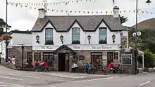
Facilities
Glenbeigh functions as a local service centre for its catchment area and as a centre of tourism, being close to Rossbeigh beach and standing at an intersection of the Kerry Way walking trail and the Ring of Kerry.[8]
The village has a church, community centre and garda station. The adjacent blue flag beach and walking routes provide outdoor recreational amenities. There are a number of small hotels, bed and breakfast accommodation and holiday homes.
References
- "Sapmap Area - Settlements - Glenbeigh". Census 2016. Central Statistics Office. 2016. Retrieved 12 July 2018.
- "Glenbeigh and Rossbeigh". GoKerry Tourism. Retrieved 12 July 2018.
- "An Bheithe/River Behy". Placenames Database of Ireland. Retrieved 1 June 2017.
- "Gleann Beithe/Glenbeigh". Placenames Database of Ireland. Retrieved 1 June 2017.
- "Gleann Beithe/Glanbehy". Placenames Database of Ireland. Retrieved 1 June 2017.
- "Glenbeigh Towers, Kilnabrack Wood, County Kerry (21306301)". National Inventory of Architectural Heritage. Retrieved 12 July 2018.
- "Volunteers recreate iconic tower in Glenbeigh village". independent.ie. Independent News & Media. 3 September 2016. Retrieved 9 June 2020.
- "Glenbeigh Local Area Plan" (PDF). Killorglin Functional Area Local Area Plan 2010-2016. Kerry County Council. Retrieved 12 July 2018.
External links
| Wikimedia Commons has media related to Glenbeigh. |